
Montserrado County is a county in the northwestern portion of the West African nation of Liberia. One of 15 counties that comprise the first-level of administrative division in the nation, it is composed of four districts. As of the 2008 Census, it had a population of 1,118,241, making it the most populous county in Liberia. The area of the county measures 1,912.7 square kilometres (738.5 sq mi), the smallest in the country. Bensonville serves as the capital.

Bong is a county in the north-central portion of the West African nation of Liberia. One of 15 counties that comprise the first-level of administrative division in the nation, it has twelve districts. Gbarnga serves as the capital. The area of the county measures 8,772 square kilometres (3,387 sq mi). As of the 2008 Census, it had a population of 328,919, making it the third-most populous county in Liberia. The county was organized in 1964 and is important for its mining industry.
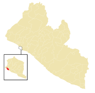
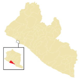
Careysburg District is one of four districts located in Montserrado County, Liberia. Bensonville is the capital, and the total district population is 28,463.
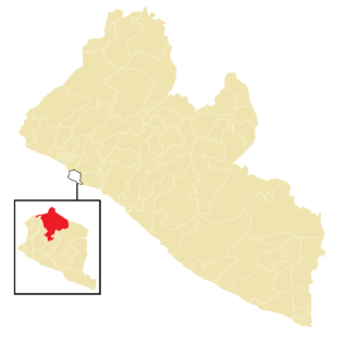
Greater Monrovia is one of four districts located in Montserrado County, Liberia. It contains the country's capital Monrovia. It recorded a population of 970,824 in the 2008 census.

West Point is a township of the Liberian capital city of Monrovia, located on a 0.53 km2 peninsula which juts out into the Atlantic Ocean between the Mesurado and Saint Paul rivers. West Point is one of Monrovia's most densely populated slums.
Caldwell is a township located in Montserrado County, Liberia. Caldwell was one of the four townships established in the first wave of colonization. It is listed as one of the original settlements comprising the Commonwealth of Liberia in the 1839 Constitution, which was drafted by the American Colonization Society. The name comes from Elias B. Caldwell and family, about 1816, Presbyterians in what became Caldwell, New Jersey.

New Georgia is a township in Montserrado County, Liberia that was first settled by Africans who had been taken from slave ships seized or wrecked near the United States and then sent to Liberia after several years had passed.
Chocolate City is a central-northern suburb of Monrovia, Liberia. It is located in the New Georgia Township. Chocolate City contains the Elizabeth Blunt School and Francis Freeman Elementary School.
New Kru Town is a northwestern coastal suburb of Monrovia, Liberia.
Chicken Soup Factory is a community in Gardnesville Township, Greater Monrovia District, Liberia. The name hails from a defunct Maggi chicken bouillon cube factory located in the area.
Swankamore is a community in Congo Town, Greater Monrovia District, Liberia. The community is located SKD Boulevard.
Dixville is a township in Greater Monrovia District, Montserrado County, Liberia. The Dixville township was one of five townships founded in the second wave of colonization, between 1828 and 1847.
The Greater Monrovia District, i.e. the district covering the Liberian capital Monrovia is divided into 160+ communities, below listed by municipal administration and electoral district;
Montserrado-8 is an electoral district for the elections to the House of Representatives of Liberia. The district covers the Monrovia communities of Bassa Community, Bernard Quarters, Bishop Brooks, Buzzi Quarters, Capitol Hill, Crown Hill, Jallah Town, Maternity Community, Rock Spring Valley, Plumkor, Saye Town Slipway, Soniwein and Warwein, as well as the western parts of Cooper Clinic and Ocean View communities. The 12th Street constitutes the boundary between Montserrado-8 and Montserrado-9.
Montserrado-10 is an electoral district for the elections to the House of Representatives of Liberia. The district covers all of the communities of the Congo Town township, except Pagos Island and Swankamore.
Montserrado-11 is an electoral district for the elections to the House of Representatives of Liberia. The district covers the eastern parts of Caldwell township, all of Dixville township, parts of Barnersville township and four communities of the Gardnersville township.

Montserrado-13 is an electoral district for the elections to the House of Representatives of Liberia. The district covers the New Georgia Township as well as the St. Michael community of Gardnersville Township and the Stockton Creek and Jamaica Road communities of Garwolon Township.

Montserrado-14 is an electoral district for the elections to the House of Representatives of Liberia. The district covers the southern half of Garwolon Township, i.e. the communities of Vai Town A, Vai Town B, Giblata, Central Clara Town I, Central Clara Town II, Paity Town, River View, Peugeot Garage, Hope Community, Struggle Community, Free Port Community and Cow Factory.

Montserrado-15 is an electoral district for the elections to the House of Representatives of Liberia. The district covers the northern parts of Garwolon Township, i.e. the communities of Blamo Town, Central Logan Town, Free Port Development, Gbandi Town, King Peter Town, Little White Chapel, Vicky Spot, Zinc Camp and Zondo Town, as well as the western parts of Caldwell Township, i.e. Caldwell Community, New Georgia Road, Central Caldwell and Lower Caldwell A.

The Garworlohn Township is a township of the Greater Monrovia District, Montserrado County, Liberia. It is located on Bushrod Island, and stretches from Vai Town in the south to Bong Mines Bridge in the north. Politically, Garworlohn Township is divided between the Montserrado-13, Montserrado-14 and Montserrado-15 electoral districts.