Surkhet District is a district in Karnali Province of mid-western Nepal. Surkhet is the one of the ten districts of Karnali located about 600 kilometres (373 mi) west of the national capital Kathmandu. The district's area is 2,489 square kilometres (961 sq mi). It had 288,527 population in 2001 and 350,804 in 2011 which male comprised 169,461 and female 181,381. Its district headquarters, Birendranagar, is the capital of Karnali Province. It is serving as a business hub and document center for Karnali province. According to population, development, road links, landforms, climate, many peoples are migrating here. after becoming province capital developmental activities are boosted and are in peak level. all the governmental works are carried here. Birendranagar is beautiful valley surrounded by hills having moderate climate.

Bandipur is a hilltop settlement and a rural municipality in Tanahun District, Gandaki province of Nepal. Bandipur is primarily known for its preserved, old time cultural atmosphere. At the time of the 2011 Nepal census it had a population of total 15,591 people living in 3,750 individual households.

Hetauda is a sub-metropolitan city in the Makwanpur District of Bagmati Province in central Nepal. It is the administrative headquarters of the Makwanpur District and the capital of Bagmati Province as declared by majority Provincial Assembly Members on 12 January 2020. It is one of the largest cities of Nepal. At the time of the 2015 Nepal census, it had a population of 153,875 people. The city had a population of 195,951 in 2021.
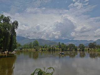
Birendranagar officially Birendranagar Municipality is a city in Surkhet District in Karnali Province of Nepal. It is the district headquarter of Surkhet District and also the capital city of Karnali province. As of March 2022, Birendranagar has a population of 154,886 making it the 17th largest city of Nepal. It is the largest city of karnali province and 7th largest in Western Nepal. It is one of the fastest growing cities of Nepal. Birendranagar is the destination of two national highways i.e Ratna Highway and Karnali Highway. It is one of the constituent city of Ratna Highway Metropolitan Areas along with Nepalgunj and Kohalpur. Birendranagar is compromise of panoramic view of Mahabharata and chure ranges and the plain of inner terai. Birendranagar is a major trade center in mid-western Nepal and is considered as the most expensive city to live in Nepal.

Devghat is one of the famous religious and cultural centers in central Nepal. At the time of the 1991 Nepal census it had a population of 5786 people living in 1132 individual households.

Chaukidanda is an administrative Headquarter of Salpasilichho Rural Municipality in Bhojpur District in the Province No. 1 of eastern Nepal. It is ward no.-3 too on newly formed Salpasilichho Rural Municipality in northern part of District.
Salyan is a town and Village Development Committee in Kaski District in the Gandaki Zone of northern-central Nepal. At the time of the 1991 Nepal census it had a population of 3,254 persons living in 665 individual households.

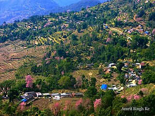
Sankhar is a village development committee in Chapakot Municipality of Syangja District in Gandaki Province of central Nepal. At the time of the 2011 Nepal census it had a population of 4,630 people residing in 1,055 individual households. Majuwa, Mohami, Bhattarai Danda, Keladighat, Patasar, Panglung, Salghari, Manechaur, Khasa Bankata, Pipalchhap, Khardi, Samakot, Tangle, Gahate, Ajingare, and Hadiban are major villages in Sankhar.
Bhimad is a municipality in Tanahu District in the Gandaki Zone of central Nepal. At the time of the 2011 Nepal census the city had a population of 8,414 people living in 2,191 individual households. It is 30 minutes away from Khairenitar. Due to its historic importance, a plan is underway to incorporate the Shukla Gandaki municipality and form the Bhimad Sub-metropolitan City in the near future. This is being done in order to improve the integrated development of this region because the city is currently experiencing accelerated development. While Bhimad lacks sufficient hospital facilities for its population size, there are many health centers in various communities.
Dulegaunda is a town and market center in Shuklagandaki Municipality in Tanahun District in the Gandaki Zone of central Nepal. The formerly Village Development Committee was merged to form the new municipality since 18 May 2014. At the time of the 1991 Nepal census it had a population of 7412 people living in 1507 individual households.
Ghiring Sundhara is a village development committee in Tanahun District in the Gandaki Zone of central Nepal. At the time of the 1991 Nepal census it had a population of 5524 people living in 1162 individual households.
Sunkhani is a ward committee located in Kalinchowk Rural Municipality of Dolakha District in the Bagmati Province of north-eastern Nepal. Formally it was a Village Development Committee of Dolakha District. Sunkhani consists of two ward committees. The office of Kalinchowk Rural Municipality also lies in Sunkhani ward number 08.
Bhiman is a town in Kamalamai Municipality Ward no. 11 in Sindhuli District in the Janakpur Zone of south-eastern Nepal. At the time of the 1991 Nepal census it had a population of 7,609 people living in 1,389 individual households.

Dudhauli is a municipality of the Sindhuli District in the Janakpur Zone of south-eastern Nepal.
Dhap is a market center in Api Municipality in Darchula District in the Mahakali Zone of western Nepal. The formerly Village Development Committee was merged to form new municipality since 18 May 2014. At the time of the 1991 Nepal census it had a population of 4092 people living in 694 individual households. The major ethnic group living in Dhap are Brahmins and Chhetris with the majority of Bista (Brahmin), Joshi, Bhatta, Pant, Raikhola caste. Temple of God Malikarjun and Temple of God =Latinath are two main religious sites. The main educational institute is Malikarjun Higher Secondary School and College, where one can study up to Undergraduate level from Elementary Level.

Surunga is a trade center of Jhapa District. It is located in Kankai Municipality in Jhapa District in the Province No. 1 of south-eastern Nepal. At the time of the 1991 Nepal census it had a population of 16,747 people living in 2996 individual households. Surunga is one of the rapidly developing towns of Jhapa district. It is situated on the bank of the Kankai River.

Katahariya is a municipality in Rautahat District in the Narayani Zone of south-eastern Nepal. Before September 2017, Katahariya was one of the Village Development Committees with 8 wards. At the time of the 1991 Nepal census, it had a population of 4,619 people living in 835 individual households. Katahariya is famous for its vegetables and cattle market. It has a well-maintained Farmers' market (vegetable) and Cattle (domestic-animal) market. Katahariya is a fast-growing VDC, with the main occupations of local people being business and farming.

Rampur is a municipality in Palpa District in Lumbini Province of West southern Nepal. According to hindu mythology, Maharishi Vasistha taught Yogavasistha to lord Rama in the cave of Rampur. Rampur is 65 km northeast from the headquarter city Tansen. The valley is bounded by Syangja District in the north, Tanahun District in the northeast, and Nawalparasi District in the east. The popular religious river Kaligandaki disconnects the boundary in the northern part.
Meghauli is a village and former Village Development Committee that is now part of Bharatpur Metropolitan City in Bagmati Province of central Nepal.
Madhumalla is a village development committee in Morang District in the Koshi Zone of south-eastern Nepal. With a population of 21,482 as of the 2011 Nepal census and situated at the foothills of Raja rani mountain, Madhumalla is a village sandwiched by two rivers Mawa and Nunsari. Its neighbours are Urlabari municipality to its south, Damak municipality to its east and south, and Illam district to its north. This village is at a distance of 7.3 km north of Urlabari


