Khan River

Last updated
Khan River
Khan Rivier 29.01.2009.jpg
Physical characteristics
SourceOtjisemba, northwest of Okahandja
  location Otjozondjupa Region
  coordinates 22°42′S14°54′E / 22.700°S 14.900°E / -22.700; 14.900
Mouth Swakop River
  location
c.40 kilometres (25 mi) east of Swakopmund
Basin size8,400 km2 (3,200 sq mi)
Basin features
Tributaries 
  right Slang River, Etiro River

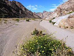
The river Khan is an ephemeral river crossing the Erongo region of central Namibia. It is the main tributary of the Swakop River [1] and only occasionally carries surface water during the rainy season from November to February/March. Khan's catchment area including its tributaries Slang and Etiro stretches over 8,400 square kilometres (3,200 sq mi). [2]

The Khan has its origin near the settlement of Otjisemba, north-west of Okahandja. From there the river course passes westwards to the town of Usakos, and further in a south-western direction through the Namib desert. It has its confluence with the Swakop River 40 km east of Swakopmund. [3]

It is a popular tourist attraction due to the proliferation of mammals such as the klipspringer antelope, [4] ostriches and jackals.

Related Research Articles

<span class="mw-page-title-main">Namib</span> Desert in Southern Africa

The Namib is a coastal desert in Southern Africa. According to the broadest definition, the Namib stretches for more than 2,000 kilometres (1,200 mi) along the Atlantic coasts of Angola, Namibia, and South Africa, extending southward from the Carunjamba River in Angola, through Namibia and to the Olifants River in Western Cape, South Africa. The Namib's northernmost portion, which extends 450 kilometres (280 mi) from the Angola-Namibia border, is known as Moçâmedes Desert, while its southern portion approaches the neighboring Kalahari Desert. From the Atlantic coast eastward, the Namib gradually ascends in elevation, reaching up to 200 kilometres (120 mi) inland to the foot of the Great Escarpment. Annual precipitation ranges from 2 millimetres (0.079 in) in the aridest regions to 200 millimetres (7.9 in) at the escarpment, making the Namib the only true desert in southern Africa. Having endured arid or semi-arid conditions for roughly 55–80 million years, the Namib may be the oldest desert in the world and contains some of the world's driest regions, with only western South America's Atacama Desert to challenge it for age and aridity benchmarks.

<span class="mw-page-title-main">Namib-Naukluft National Park</span> National park in Namibia

The Namib-Naukluft Park is a national park in western Namibia, situated between the coast of the Atlantic Ocean and the edge of the Great Escarpment. It encompasses part of the Namib Desert, the Naukluft mountain range, and the lagoon at Sandwich Harbour. The best-known area of the park and one of the main visitor attractions in Namibia is Sossusvlei, a clay pan surrounded by dunes, and Sesriem, a small canyon of the Tsauchab. The desert research station of Gobabeb is situated within the park.

<span class="mw-page-title-main">Kuiseb River</span> River in Erongo, Namibia

The Kuiseb River is an ephemeral river in western-central Namibia. Its source is in the Khomas Highland west of Windhoek. From there it flows westwards through the Namib-Naukluft National Park and the Namib desert to Walvis Bay. Several settlements of the Topnaar people are on the banks of the lower Kuiseb, for instance Homeb, Sandfontein, Rooibank, and Utuseb. Inflows of the Kuiseb are Gomab, Ojab, Chausib, Gaub, Koam, Nausgomab and Goagos.

<span class="mw-page-title-main">Swakopmund</span> City in Erongo, Namibia

Swakopmund is a city on the coast of western Namibia, 352 km (219 mi) west of the Namibian capital Windhoek via the B2 main road. It is the capital of the Erongo administrative district. As of 2011, the town has 44,725 inhabitants and covers 196 km2 (76 sq mi) of land.

<span class="mw-page-title-main">Ugab River</span> River in Namibia

The Ugab River is an ephemeral river in north-western Namibia. Its lower section forms the border between Kunene Region and Erongo Region but its catchment area extends well into the Otjozondjupa Region. Ugab's source is near Otavi. From there the riverbed leads westwards past the Paresis Mountains and the Fransfontein Mountains into the Skeleton Coast and the Atlantic Ocean. Inflows of the Ugab are Erundu, Ozongombo, Okomize and Uis.

<span class="mw-page-title-main">Rössing uranium mine</span>

The Rössing Uranium Mine in Namibia is the longest-running and one of the largest open pit uranium mines in the world. It is located in the Namib Desert near the town of Arandis, 70 kilometres from the coastal town of Swakopmund. Discovered in 1928, the Rössing mine started operations in 1976. In 2005, it produced 3,711 tonnes of uranium oxide, becoming the fifth-largest uranium mine with 8 per cent of global output. Namibia is the world's fourth-largest exporter of uranium.

<span class="mw-page-title-main">Uis</span> Settlement in Erongo Region, Namibia

Uis is a settlement located in the Erongo Region, Namibia. It belongs to the Dâures electoral constituency. Located in the former Damaraland, it is known for the local mineral wealth. The settlement was established in 1958 as workers' settlement to exploit local tin deposits. It has approximately 3,600 inhabitants and, before being downgraded from "village" to "settlement" in 2010, owned 10 square kilometres (3.9 sq mi) of land.

<span class="mw-page-title-main">Swakop River</span> River in Namibia

The Swakop River is a major river in western central Namibia. Its river source is in the Khomas Highland. From there it flows westwards through the town of Okahandja, the historic mission station at Gross Barmen, and the settlement of Otjimbingwe. It then crosses the Namib desert and reaches the Atlantic Ocean at Swakopmund. The Swakop is an ephemeral river; its run-off is roughly 40 million cubic metres per annum.

<span class="mw-page-title-main">Tsauchab</span> River

The Tsauchab is an ephemeral river in the Hardap Region of central Namibia. Its source is in the southern Naukluft Mountains, from where it flows westwards through the Namib-Naukluft National Park into Sossusvlei, an endorheic basin. The lower river has in the past had a slightly different courses and also formed two other basins, the Deadvlei and the Hiddenvlei.

<span class="mw-page-title-main">Omaruru River</span> River

The Omaruru River is a major river crossing the Erongo Region of western central Namibia from East to West. It originates in the Etjo Mountains, crosses the town of Omaruru and the village of Okombahe, and reaches the sea a few kilometers north of Henties Bay. Inflows of the Omaruru are Otjimakuru, Goab, Spitzkop, Leeu and Okandjou.

The Uniab River is an ephemeral river on Namibia's Skeleton Coast, located between Torra Bay and Terrace Bay. Its mouth is in the Grootberg Mountains near Palmwag. Inflows of the Uniab are Kaikams, Kawakab, Aub, Urenindes and Obob. The river once created a large river delta with five main watercourses. Today it continues to flow only in one of the watercourses, but subterranean water surfaces as springs in the other channels. Uniab's catchment area is estimated to be between 3961 and 4,500 km2 (1,700 sq mi).

<span class="mw-page-title-main">Hoanib</span> Ephemeral seasonal river in Namibia

The Hoanib is one of the 12 ephemeral seasonal rivers in the west of Namibia, where it was the border between northern Damaraland and Kaokoland. Its length is 270 km. With the low population density, the oasis character of the river valley and the relatively high wildlife population of Hoanib, together with the Hoarusib its valley is one of the last true wilderness areas in Namibia, one of the last settlements of desert elephants and shows strong wind and water eroded and weathered stone deposits. Inflows of Hoanib are Aap River, Otjitaimo River, Ombonde, Ganamub, Mudorib and Tsuxub.

<span class="mw-page-title-main">Dorob National Park</span> National park of Namibia

Dorob National Park is a protected area in Erongo, along the central Namibian coast, which is 1,600 kilometres (990 mi) in length. It was gazetted as a national park under the Nature Conservation Ordinance No.4 of 1975 on 1 December 2010, and with Namib-Naukluft Park covers an area of 107,540 square kilometres (41,520 sq mi).

<span class="mw-page-title-main">Husab Mine</span>

The Husab Mine, also known as the Husab Uranium Project, is a uranium mine near the town of Swakopmund in the Erongo region of western-central Namibia. The mine is located approximately 60 kilometres (37 mi) from Walvis Bay. The Husab Mine is expected to be the second largest uranium mine in the world after the McArthur River uranium mine in northern Saskatchewan, Canada and the largest open-pit mine on the African continent. Mine construction started in 2014. The Husab Mine started production towards the end of 2016 after completion of the sulfuric acid leaching plant.

The Hoarusib River is an ephemeral river in the Kunene Region of north-western Namibia. Its source is near the regional capital Opuwo, and the river flows through the Tonnesen and Giraffe Mountains into the Atlantic Ocean. The Hoarusib occasionally carries surface water during the rainy seasons in November and February/March. The catchment area of the Hoarusib is 15,237 square kilometres (5,883 sq mi).

<span class="mw-page-title-main">Khumib River</span> River

The river Khumib is an ephemeral river crossing the Kunene Region of north-western Namibia. It occasionally carries surface water during the rainy seasons in November and February/March. Its catchment area is estimated between 2200 and 2,300 square kilometres (890 sq mi).

<span class="mw-page-title-main">Koigab River</span> River

The Koigab River is an ephemeral river on Namibia's Skeleton Coast. Its source is in the Grootberg Mountains near Bergsig, where its two inflows, the Gui-Tsawisib and the Springbok are located. Koigab's catchment area is estimated to be between 2320 and 2,400 km2 (930 sq mi).

<span class="mw-page-title-main">Huab River</span> River

The Huab River is an ephemeral river in the Kunene Region of north-western Namibia. Its source is southeast of Kamanjab, from where it flows westwards through Mopane savanna until it reaches the Skeleton Coast and the Atlantic Ocean. Inflows of the Huab are Klein-Omaruru, Sout, Aba-Huab, Ongwati and Klip. Huab's catchment area is estimated to be between 14,800 and 16,465 km2 (6,357 sq mi), and includes the town of Khorixas as well as the settlements Kamanjab, Fransfontein, and Anker. The Twyfelfontein World Heritage Site is located on the banks of the Aba Huab.

<span class="mw-page-title-main">Tsondab River</span> River

The Tsondab River is an ephemeral river in the Hardap Region of central Namibia. Its source is in the Remhoogte Mountains. From there it flows westwards through the Namib-Naukluft National Park before evaporating at Tsondabvlei. Inflows of the Tsondab are Diep, Noab and Koireb. Tsondab's catchment area is 3,500 km2 (1,400 sq mi).

References

  1. "ELECTIONS 2010: Erongo regional profile". New Era. 16 November 2010. Archived from the original on 6 September 2012.
  2. Strohbach, B.J. (2008). "Mapping the Major Catchments of Namibia" (PDF 1.0MB). Agricola. 2008: 63–73. ISSN   1015-2334. OCLC   940637734.
  3. Jacobson, Peter J.; Jacobson, Kathryn M.; Seely, Mary K. (1995). Ephemeral rivers and their catchments: Sustaining people and development in western Namibia (PDF 8.7MB). Windhoek: Desert Research Foundation of Namibia. pp. 138–139. ISBN   9991670947.
  4. Stuart, C.T. (October 2019). "Preliminary notes on the mammals of the Namib Desert". Madoqua. 1975 (Series 2 Issue 4): 5–36. hdl:10520/AJA10115498_55.