Khao Nom Nang, Tha Kradan

Last updated
Khao Nom Nang
เขานมนาง
Khao Nom Nang-Erawan NP41.JPG
Highest point
Elevation 752 m (2,467 ft)
Coordinates 14°21′02″N99°12′53″E / 14.35056°N 99.21472°E / 14.35056; 99.21472 Coordinates: 14°21′02″N99°12′53″E / 14.35056°N 99.21472°E / 14.35056; 99.21472
Geography
Thailand location map Topographic.png
Red triangle with thick white border.svg
Khao Nom Nang
Location in Thailand
Location Kanchanaburi, Thailand
Parent range Tenasserim Hills
Geology
Mountain type Limestone

Khao Nom Nang (Thai : เขานมนาง), "female breast mountain", is a 752 m high mountain in the Tenasserim Hills in Kanchanaburi Province, Thailand.

Thai language language spoken in Thailand

Thai, Central Thai, is the sole official and national language of Thailand and the first language of the Central Thai people and vast majority of Thai Chinese. It is a member of the Tai group of the Kra–Dai language family. Over half of Thai vocabulary is derived from or borrowed from Pali, Sanskrit, Mon and Old Khmer. It is a tonal and analytic language, similar to Chinese and Vietnamese.

Breast Region of the torso of a primate containing the mammary gland

The breast is one of two prominences located on the upper ventral region of the torso of primates. In females, it serves as the mammary gland, which produces and secretes milk to feed infants. Both females and males develop breasts from the same embryological tissues. At puberty, estrogens, in conjunction with growth hormone, cause breast development in female humans and to a much lesser extent in other primates. Breast development in other primate females generally only occurs with pregnancy.

Tenasserim Hills

Tenasserim Hills or Tenasserim Range is the geographical name of a roughly 1,700 km long mountain chain, part of the Indo-Malayan mountain system in Southeast Asia.

Contents

Description

Khao Nom Nang rises above the surrounding limestone hills between Nong Pet and Chong Sadao east of Route 3199. [1] The mountain is in the Erawan National Park area. [2]

Limestone Sedimentary rocks made of calcium carbonate

Limestone is a carbonate sedimentary rock that is often composed of the skeletal fragments of marine organisms such as coral, foraminifera, and molluscs. Its major materials are the minerals calcite and aragonite, which are different crystal forms of calcium carbonate (CaCO3). A closely related rock is dolostone, which contains a high percentage of the mineral dolomite, CaMg(CO3)2. In fact, in old USGS publications, dolostone was referred to as magnesian limestone, a term now reserved for magnesium-deficient dolostones or magnesium-rich limestones.

Erawan National Park national park of Thailand

Erawan National Park is a 550 km2 park in western Thailand in the Tenasserim Hills of Kanchanaburi Province, Amphoe Si Sawat in tambon Tha Kradan. Founded in 1975, it was Thailand's 12th national park.

See also

Related Research Articles

Kanchanaburi Province Province in Thailand

Kanchanaburi is the largest of the western provinces (changwat) of Thailand. The neighboring provinces are Tak, Uthai Thani, Suphan Buri, Nakhon Pathom, and Ratchaburi. In the west it borders Kayin State, Mon State, and the Tanintharyi Region of Myanmar.

Khao Sam Roi Yot National Park

Khao Sam Roi Yot is a marine national park in Kui Buri District, Prachuap Khiri Khan Province, Thailand. It covers 98.08 km2, of which 20.88 km2 are marine areas. The park was established in 1966, and was the first coastal national park of Thailand. The park includes Thailand's largest freshwater marsh.

Phanom District Amphoe in Surat Thani, Thailand

Phanom is a district (amphoe) in the southwest of Surat Thani Province of southern Thailand.

Khanom District Amphoe in Nakhon Si Thammarat, Thailand

Khanom is the northernmost district (amphoe) of Nakhon Si Thammarat Province, southern Thailand.

Mueang Phang Nga District Amphoe in Phang Nga, Thailand

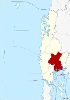
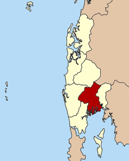
Mueang Phang Nga is the capital district of Phang Nga Province in southern Thailand.

Khao Luang mountain in southern Thailand

Khao Luang (เขาหลวง) is the tallest mountain in southern Thailand. It is in Nakhon Si Thammarat Province.

Sa Nang Manora Forest Park

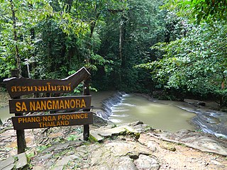
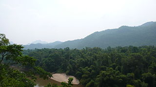
Sa Nang Manora is a forest park in southern Thailand. It covers an area of 0.29 km2 of the Khao Thoi-Nang Hong Forest, Nop Pring Sub-district, Mueang District, Phang Nga Province, about four km north of Phang Nga town. It was established on 15 September 1980.

Western Forest Complex

The Western Forest Complex, straddling two countries, Thailand and Myanmar, including 19 national parks and wildlife sanctuaries, is the main biodiversity conservation corridor of the region. Covering 18,730 km2, it is one of the largest protected territories in Southeast Asia. The geography of the Western Forest Complex ranges from lowlands to the mountains of the Thai highlands and the Dawna-Tenasserim Hills.

Ko Nom Sao Twin islands in Phang Nga Province, Thailand

Ko Nom Sao are twin islands in Phang Nga Bay, and are part of the Ko Panyi (เกาะปันหยี) subdistrict (tambon), Phang Nga Province, Thailand.

Khao Nom Sao mountain in Thailand

Khao Nom Sao (เขานมสาว), "female breast mountain", is a land feature located in Ranong Province, Thailand.

Sankamphaeng Range

The Sankamphaeng Range, also Sankambeng Range or Sungumpang Range is one of the mountain ranges separating eastern Thailand from the northeast or Isan. It is in Nakhon Nayok, Prachinburi, Sa Kaeo, Saraburi, and Nakhon Ratchasima Provinces, Thailand.

Ramkhamhaeng National Park

Ramkhamhaeng National Park is a national park in Thailand.

This is a list of articles related to Thailand, sorted by alphabetical order. It represents the majority of articles contained within the Thailand category. For a list of key articles arranged by topic, see Outline of Thailand.

Breast-shaped hill Wikimedia list article

A breast-shaped hill is a mountain in the shape of a woman's breast. Some such hills are named "Pap", a word for the breast or nipple. Such anthropomorphic geographic features are to be found in different places of the world and in some cultures they were revered as the attributes of the Mother Goddess, such as the Paps of Anu, named after Anu, an important female deity of pre-Christian Ireland.

Phi Pan Nam Range mountain range in Thailand and Laos

The Phi Pan Nam Range, also Pee Pan Nam, is a 400 km (249 mi) long system of mountain ranges in the eastern half of the Thai highlands. It is mostly in Thailand, although a small section in the northeast is within Sainyabuli and Bokeo Provinces, Laos.

Phu Langka Forest Park

The Phu Langka Forest Park, or Phu Lang Ka Forest Park, is a protected area of the Phi Pan Nam Range located in Chiang Kham District and Pong District, Phayao Province, Thailand. The park was established on May 8, 2002 and covers an area of 12.48 km².

Khao Rom mountain in Thailand

Khao Rom is a 1,351-metre-high (4,432 ft) mountain in Nakhon Ratchasima Province, Thailand. It is the highest peak of the Sankamphaeng Range, between eastern Thailand and Isan.

References

  1. Roadway Thailand Atlas, Groovy Map Co., Ltd. April 2010
  2. Erawan National Park Archived 2006-12-08 at the Wayback Machine