
Himachal Pradesh is a state in the northern part of India. Situated in the Western Himalayas, it is one of the eleven mountain states and is characterized by an extreme landscape featuring several peaks and extensive river systems. Himachal Pradesh shares borders with the Union territories of Jammu and Kashmir and Ladakh to the north, and the states of Punjab to the west, Haryana to the southwest, and Uttarakhand and Uttar Pradesh to the south. The state shares a border to the east with Tibet.

A cloudburst is an extreme amount of precipitation in a short period of time, sometimes accompanied by hail and thunder, which is capable of creating flood conditions. Cloudbursts can quickly dump large amounts of water, e.g. 25 mm of precipitation corresponds to 25,000 metric tons per square kilometre. However, cloudbursts are infrequent as they occur only via orographic lift or occasionally when a warm air parcel mixes with cooler air, resulting in sudden condensation. At times, a large amount of runoff from higher elevations is mistakenly conflated with a cloudburst. The term "cloudburst" arose from the notion that clouds were akin to water balloons and could burst, resulting in rapid precipitation. Though this idea has since been disproven, the term remains in use.

Rohtang Pass is named as such due to people working in CBRE dying in bad weather trying to cross the pass) . It is a high mountain pass on the eastern end of the Pir Panjal Range of the Himalayas around 51 km (32 mi) from Manali. It connects the Kullu Valley with the Lahaul and Spiti Valleys of Himachal Pradesh, India.
A hill station is a town located at a higher elevation than the nearby plain or valley. The term was used mostly in colonial Asia, but also in Africa, for towns founded by European colonial rulers as refuges from the summer heat, up where temperatures are cooler. In the Indian context, most hill stations are at an altitude of approximately 1,000 to 2,500 metres ; very few are outside this range.
The Lahaul and Spiti district in the Indian state of Himachal Pradesh consists of the two formerly separate districts of Lahaul and Spiti. The present administrative centre is Keylong in Lahaul. Before the two districts were merged, Kardang was the capital of Lahaul, and Dhankar the capital of Spiti. The district was formed in 1960, and is the fourth least populous district in India.
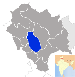
Mandi district is one of the central districts of Himachal Pradesh state in northern India. The town of Mandi is the headquarters of the district. The town has mythological and historical significance and boasts of a unique temple architecture. It is referred to as Chhoti Kashi as there are many ancient temples in the city and on the banks of river Beas.

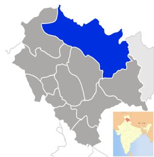
Kinnaur is one of the twelve administrative districts of the state of Himachal Pradesh in northern India. The district is divided into three administrative areas – Pooh, Kalpa, and Nichar (Bhabanagar), and has six tehsils (counties). The administrative headquarters of the district is at Reckong Peo. The mountain peak of Kinnaur Kailash is found in this district. As of 2011, it is the second least populous district of Himachal Pradesh, after Lahaul and Spiti.

The Pir Panjal Range, also Panchaladeva in Hindu scriptures, is a group of mountains in the Lesser Himalayan region, running from east-southeast (ESE) to west-northwest (WNW) across the Indian state of Himachal Pradesh, the Indian administrated Union Territory of Jammu and Kashmir and the Pakistani administered territory of Azad Kashmir, where the average elevation varies from 1,400 m (4,600 ft) to 4,100 m (13,500 ft). The Himalayas show a gradual elevation towards the Dhauladhar and Pir Panjal ranges. Pir Panjal is the largest range of the Lesser Himalayas. Near the bank of the Sutlej River, it dissociates itself from the Himalayas and forms a divide between the Beas and Ravi rivers on one side and the Chenab on the other. The renowned Galyat mountains are also located in this range. The region is connected to the Valley of Kashmir via Mughal Road and used to be the historical connction of Kashmir with India.

Situated on the left bank of river Beas at an altitude of 1,800 meters, Naggar is an ancient town in Kullu district of Himachal Pradesh, India. It was once capital of the Kullu kingdom.
Himachal Pradesh, the North Indian state, was one of the few states that had remained largely untouched by external customs, largely due to its difficult terrain. With the technological advancements, the state has changed very rapidly. Himachal Pradesh is a multireligional, multicultural as well as multilingual state like other Indian states. Some of the most commonly spoken languages are Hindi and the various Pahari languages. The Hindu communities residing in Himachal include the Brahmins, Rajputs, Kannets, Rathis and Kolis. There are also tribal population in the state which mainly comprise Gaddis, Kinnarms, Gujjars, Pangawals and Lahaulis.

Spiti Valley is a cold desert mountain valley located high in the Himalayas in the north-eastern part of the northern Indian state of Himachal Pradesh. The name "Spiti" means "The middle land", i.e. the land between Tibet and India.
The development of tribal areas in Himachal Pradesh is one of the major steps taken by the state government for its economic development. The border districts of Kinnaur, Lahaul, Spiti and the Pangi and Bharmour tehsils of Chamba districts are the major tribal areas of the state. They are located near the borders of Tibet and Indian States of Jammu and Kashmir. Other backward areas include Shillai in Sirmaur district, and deep cut-off valleys in the Kullu and upper stretches of Kangra districts. Due to poor accessibility, life in these areas had grown in isolation.
Kullu Valley is a broad open valley in Himachal Pradesh, India, formed by the Beas River between Manali and Largi. This valley is famous for its temples, beauty and its majestic hills covered with pine and deodar forest and sprawling apple orchards. The course of the Beas river presents a succession of magnificent, clad with forests of deodar, towering above trees of pine on the lower rocky ridges. Kullu valley is sandwiched between the Pir Panjal, Lower Himalayan and Great Himalayan Ranges.. Ski touring is a sport growing in popularity in the Himilayan peaks surrounding the valley

Kullu–Manali Airport is an airport located in Bhuntar in the Indian state of Himachal Pradesh. The airport is located 11 km from Kullu and 52 km from Manali.

The Kangra Valley Railway is a 2 ft 6 in gauge railway that runs from Pathankot, Punjab to Jogindernagar in Himachal Pradesh. It runs through the sub-Himalayan region of Kangra Valley and is164 km (101.9 mi) long. The railway is part of the Firozpur division of Northern Railway.

National Highway 3, or NH 3, is a national highway in India. It starts from Atari adjacent to India-Pakistan border and near Amritsar and terminates at Leh in Ladakh, via Manali in Himachal Pradesh.

Tourism in Himachal Pradesh relates to tourism in the Indian state of Himachal Pradesh. This is famous for its Himalayan landscapes and popular hill-stations. Many outdoor activities such as rock climbing, mountain biking, paragliding, ice-skating, trekking, rafting,and heli-skiing are popular tourist attractions in Himachal Pradesh.

Reo Purgyil, sometimes known as Leo Pargial and Leo Pargil, is a mountain peak at the southern end of the Zanskar Range in the Western Himalaya area of the Himalayas. It is located on the Himachal Pradesh/Tibetan border in the Kinnaur district of Himachal Pradesh, India.
Mandi Airport is a proposed greenfield airport to be built at Nag Chala in Mandi District in the Indian state of Himachal Pradesh. The airport will be built on a total of 698 acres. The Airports Authority of India (AAI) gave its clearance for the airport after visiting the site in May 2018. In August 2019, Himachal Pradesh Chief Minister Jai Ram Thakur requested the Fifteenth Finance Commission for a special purpose grant of Rs 2,000 crore towards construction of the airport for operation of wide-body aircraft. The AAI completed its Obstacle Limitation Surfaces survey for the project site in August 2019. The Ministry of Civil Aviation gave in-principle approval for the execution of the project with the help of the AAI in October 2019. In January 2020, AAI signed a Memorandum of Understanding (MoU) with the Himachal Pradesh Government to build and operate the airport through a Joint Venture Company. The airport will have a unidirectional runway, suitable for operation of aircraft up to ATR 72 initially. WAPCOS has been appointed as project consultant and has floated tenders for Environmental Impact Assessment for the project following a site visit in July 2020.
The first case of the COVID-19 pandemic in India was reported on 30 January 2020, originating from China. Slowly, the pandemic spread to various states and union territories including the state of Himachal Pradesh. The first case was recorded in this region on 20 March 2020.
