
Kharkoo is a village on the right bank of Shyok River in the Ghanche District of Gilgit-Baltistan, Pakistan. [1]
Kharkoo is a village on the right bank of Shyok River in the Ghanche District of Gilgit-Baltistan, Pakistan. [1]

East Pakistan was the eastern province of Pakistan between 1955 and 1971, restructured and renamed from the province of East Bengal and covering the territory of the modern country of Bangladesh. Its land borders were with India and Burma, with a coastline on the Bay of Bengal. East Pakistanis were popularly known as "Pakistani Bengalis"; to distinguish this region from India's state West Bengal, East Pakistan was known as "Pakistani Bengal". In 1971, East Pakistan became the newly independent state Bangladesh, which means "country of Bengal" or "country of Bengalis" in Bengali language.

Karachi is the capital city of the Pakistani province of Sindh. It is the largest city in Pakistan and the 12th largest in the world, with a population of over 20 million. It is situated at the southern tip of the country along the Arabian Sea coast and formerly served as the capital of Pakistan. Ranked as a beta-global city, it is Pakistan's premier industrial and financial centre, with an estimated GDP of over $200 billion (PPP) as of 2021. Karachi is a metropolitan city and is considered Pakistan's most cosmopolitan city, and among the country's most linguistically, ethnically, and religiously diverse regions, as well as one of the country's most progressive and socially liberal cities.

Osama bin Laden was a Saudi Arabian-born Islamist dissident and militant leader who was the founder and first general emir of al-Qaeda. Ideologically a pan-Islamist, he participated in the Afghan jihad against the Soviet Union and supported the activities of the Bosnian mujahideen during the Yugoslav Wars. After issuing his declaration of war against the Americans in 1996, Bin Laden began advocating attacks targeting U.S. assets in several countries, and supervised al-Qaeda’s execution of the September 11 attacks in the United States in 2001.
Pakistan, officially the Islamic Republic of Pakistan, is a country in South Asia. It is the fifth-most populous country, with a population of over 241.5 million, having the second-largest Muslim population as of 2023. Islamabad is the nation's capital, while Karachi is its largest city and financial centre. Pakistan is the 33rd-largest country by area. Bounded by the Arabian Sea on the south, the Gulf of Oman on the southwest, and the Sir Creek on the southeast, it shares land borders with India to the east; Afghanistan to the west; Iran to the southwest; and China to the northeast. It shares a maritime border with Oman in the Gulf of Oman, and is separated from Tajikistan in the northwest by Afghanistan's narrow Wakhan Corridor.

Urdu is an Indo-Aryan language spoken chiefly in South Asia. It is the national language and lingua franca of Pakistan, where it is also an official language alongside English. In India, Urdu is an Eighth Schedule language, the status and cultural heritage of which are recognised by the Constitution of India; and it also has an official status in several Indian states. In Nepal, Urdu is a registered regional dialect and in South Africa, it is a protected language in the constitution. It is also spoken as a minority language in Afghanistan and Bangladesh, with no official status.

Since the Partition of British India in 1947 and subsequent creation of the dominions of India and Pakistan, the two countries have been involved in a number of wars, conflicts, and military standoffs. A long-running dispute over Kashmir and cross-border terrorism have been the predominant cause of conflict between the two states, with the exception of the Indo-Pakistani War of 1971, which occurred as a direct result of hostilities stemming from the Bangladesh Liberation War in erstwhile East Pakistan.

The Partition of India in 1947 was the change of political borders and the division of other assets that accompanied the dissolution of the British Raj in the Indian subcontinent and the creation of two independent dominions in South Asia: India and Pakistan. The Dominion of India is today the Republic of India, and the Dominion of Pakistan—which at the time comprised two regions lying on either side of India—is now the Islamic Republic of Pakistan and the People's Republic of Bangladesh. The partition was outlined in the Indian Independence Act 1947. The change of political borders notably included the division of two provinces of British India, Bengal and Punjab. The majority Muslim districts in these provinces were awarded to Pakistan and the majority non-Muslim to India. The other assets that were divided included the British Indian Army, the Royal Indian Navy, the Royal Indian Air Force, the Indian Civil Service, the railways, and the central treasury. Provisions for self-governing independent Pakistan and India legally came into existence at midnight on 14 and 15 August 1947 respectively.
The Pakistan Air Force (PAF) is the aerial warfare branch of the Pakistan Armed Forces, tasked primarily with the aerial defence of Pakistan, with a secondary role of providing air support to the Pakistan Army and Pakistan Navy when required, and a tertiary role of providing strategic airlift capability to Pakistan. As of 2024, as per the International Institute for Strategic Studies, the PAF has more than 70,000 active-duty personnel. PAF stands as the eight largest Air Force in the world. PAF is the largest Air Force of the Muslim world in terms of aircraft fleet. Its primary mandate and mission is "to provide, in synergy with other inter-services, the most efficient, assured and cost effective aerial defence of Pakistan." Since its establishment in 1947, the PAF has been involved in various combat operations, providing aerial support to the operations and relief efforts of the Pakistani military. Under Article 243, the Constitution of Pakistan appoints the President of Pakistan as the civilian Commander-in-Chief of the Pakistan Armed Forces. The Chief of the Air Staff (CAS), by statute a four-star air officer, is appointed by the President with the consultation and confirmation needed from the Prime Minister of Pakistan.
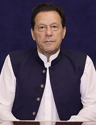
Imran Ahmed Khan Niazi is a Pakistani politician and former cricketer who served as the 22nd prime minister of Pakistan from August 2018 until April 2022. He is the founder and former chairman of the political party Pakistan Tehreek-e-Insaf (PTI) from 1996 to 2023. He was the captain of the Pakistan national cricket team throughout the 1980s and early 1990s.

The prime minister of Pakistan is the head of government of the Islamic Republic of Pakistan. Executive authority is vested in the prime minister and his chosen cabinet, despite the president of Pakistan serving as the nominal head of executive. The prime minister is often the leader of the party or the coalition with a majority in the lower house of the Parliament of Pakistan, the National Assembly where he serves as Leader of the House. Prime minister holds office by virtue of their ability to command the confidence of the National Assembly. The prime minister is designated as the "chief executive of the Islamic Republic".

The Indo-Pakistani war of 1971, also known as the third India-Pakistan war, was a military confrontation between India and Pakistan that occurred during the Bangladesh Liberation War in East Pakistan from 3 December 1971 until the Pakistani capitulation in Dhaka on 16 December 1971. The war began with Pakistan's Operation Chengiz Khan, consisting of preemptive aerial strikes on eight Indian air stations. The strikes led to India declaring war on Pakistan, marking their entry into the war for East Pakistan's independence, on the side of Bengali nationalist forces. India's entry expanded the existing conflict with Indian and Pakistani forces engaging on both the eastern and western fronts. Thirteen days after the war started, India achieved a clear upper hand, and the Eastern Command of the Pakistan military signed the instrument of surrender on 16 December 1971 in Dhaka, marking the formation of East Pakistan as the new nation of Bangladesh. Approximately 93,000 Pakistani servicemen were taken prisoner by the Indian Army, which included 79,676 to 81,000 uniformed personnel of the Pakistan Armed Forces, including some Bengali soldiers who had remained loyal to Pakistan. The remaining 10,324 to 12,500 prisoners were civilians, either family members of the military personnel or collaborators (Razakars).

The Indo-Pakistani war of 1965, also known as the second India–Pakistan war, was an armed conflict between Pakistan and India that took place from August 1965 to September 1965. The conflict began following Pakistan's unsuccessful Operation Gibraltar, which was designed to infiltrate forces into Jammu and Kashmir to precipitate an insurgency against Indian rule. The seventeen day war caused thousands of casualties on both sides and witnessed the largest engagement of armoured vehicles and the largest tank battle since World War II. Hostilities between the two countries ended after a ceasefire was declared through UNSC Resolution 211 following a diplomatic intervention by the Soviet Union and the United States, and the subsequent issuance of the Tashkent Declaration. Much of the war was fought by the countries' land forces in Kashmir and along the border between India and Pakistan. This war saw the largest amassing of troops in Kashmir since the Partition of India in 1947, a number that was overshadowed only during the 2001–2002 military standoff between India and Pakistan. Most of the battles were fought by opposing infantry and armoured units, with substantial backing from air forces, and naval operations.

The Bangladesh Liberation War, also known as the Bangladesh War of Independence and known as the Liberation War in Bangladesh, was an armed conflict sparked by the rise of the Bengali nationalist and self-determination movement in East Pakistan, which resulted in the independence of Bangladesh. The war began when the Pakistani military junta based in West Pakistan—under the orders of Yahya Khan—launched Operation Searchlight against the people of East Pakistan on the night of 25 March 1971, initiating the Bangladesh genocide.
The Pakistan national cricket team has represented Pakistan in international cricket since 1952. It is controlled by the Pakistan Cricket Board (PCB), the governing body for cricket in Pakistan, which is a Full Member of the International Cricket Council (ICC). Pakistan compete in cricket tours and tournaments sanctioned by the PCB and other regional or international cricket bodies in Test, One Day International (ODI), and Twenty20 International (T20) formats. Pakistan are current ICC Champions Trophy holders.

The Kargil War, also known as the Kargil conflict,[note (I)] was fought between India and Pakistan from May to July 1999 in the Kargil district of Ladakh and elsewhere along the Line of Control (LoC). In India, the conflict is also referred to as Operation Vijay, which was the codename of the Indian military operation in the region. The Indian Air Force acted jointly with the Indian Army to flush out the Pakistan Army and paramilitary troops from vacated Indian positions along the LoC, in what was designated as Operation Safed Sagar.

The Pakistan Army, commonly known as the Pak Army, is the land service branch and the largest component of the Pakistan Armed Forces. The president of Pakistan is the supreme commander of the army. The Chief of Army Staff (COAS), a four-star general, commands the army. The Army was established in August 1947 after Pakistan gained independence from the United Kingdom. According to statistics provided by the International Institute for Strategic Studies (IISS) in 2024, the Pakistan Army has approximately 560,000 active duty personnel, supported by the Pakistan Army Reserve, the National Guard and the Civil Armed Forces. Pakistan Army is the sixth-largest army in the world and the largest in the Muslim world.

On May 2, 2011, Osama bin Laden, the founder and first leader of the Islamist militant group al-Qaeda, was shot and killed at his compound in the Pakistani city of Abbottabad by United States Navy SEALs of SEAL Team Six. The operation, code-named Operation Neptune Spear, was carried out in a CIA-led mission, with the Joint Special Operations Command (JSOC) coordinating the Special Mission Units involved in the raid. In addition to SEAL Team Six, participating units under JSOC included the 160th Special Operations Aviation Regiment (Airborne), also known as the "Night Stalkers", and the CIA's Special Activities Division, which heavily recruits from former JSOC Special Mission Units. The success of the operation ended a nearly decade-long manhunt for bin Laden, who was accused of masterminding the September 11 attacks on the United States.
Dawood Ibrahim is an Indian mob boss, drug lord, and terrorist from Dongri, Mumbai, who is wanted by the Indian government. He reportedly heads the Indian organised crime syndicate D-Company, which he founded in Mumbai in the 1970s. Ibrahim is wanted on charges including murder, extortion, targeted killing, drug trafficking, and terrorism.

Muhammad Ali Jinnah was a barrister, politician, and the founder of Pakistan. Jinnah served as the leader of the All-India Muslim League from 1913 until the inception of Pakistan on 14 August 1947 and then as the Republic of Pakistan's first governor-general until his death.
| | This Gilgit-Baltistan location article is a stub. You can help Wikipedia by expanding it. |