
The Indus is a transboundary river of Asia and a trans-Himalayan river of South and Central Asia. The 3,180 km (1,980 mi) river rises in mountain springs northeast of Mount Kailash in Western Tibet, flows northwest through the disputed region of Kashmir, bends sharply to the left after the Nanga Parbat massif, and flows south-by-southwest through Pakistan, before emptying into the Arabian Sea near the port city of Karachi.

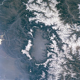
Kashmir is the northernmost geographical region of the Indian subcontinent. Until the mid-19th century, the term "Kashmir" denoted only the Kashmir Valley between the Great Himalayas and the Pir Panjal Range. The term has since come to encompass a larger area that includes the India-administered territories of Jammu and Kashmir and Ladakh, the Pakistan-administered territories of Azad Kashmir and Gilgit-Baltistan, and the Chinese-administered territories of Aksai Chin and the Trans-Karakoram Tract.

Keri Lynn Russell is an American actress. She played the title role in the drama series Felicity (1998–2002), which won her a Golden Globe Award, and later portrayed Elizabeth Jennings in the spy thriller series The Americans (2013–2018), which earned her nominations for several Primetime Emmy and Golden Globe Awards. For playing the title role in the political drama series The Diplomat (2023–present), she received further Primetime Emmy and Golden Globe nominations. She has also received a record six nominations for the Critics' Choice Television Award for Best Actress in a Drama Series.

The Karakoram Highway, also known as the KKH, National Highway 35, N-35, and the China–Pakistan Friendship Highway, is a 1,300 km (810 mi) national highway which extends from Hasan Abdal in the Punjab province of Pakistan to the Khunjerab Pass in Gilgit-Baltistan, where it crosses into China and becomes China National Highway 314. The highway connects the Pakistani provinces of Punjab and Khyber Pakhtunkhwa plus Gilgit-Baltistan with China's Xinjiang Uyghur Autonomous Region. The highway is a popular tourist attraction and is one of the highest paved roads in the world, passing through the Karakoram mountain range, at 36°51′00″N75°25′40″E at maximum elevation of 4,714 m (15,466 ft) near Khunjerab Pass. Due to its high elevation and the difficult conditions under which it was constructed, it is often referred to as the Eighth Wonder of the World. The highway is also a part of the Asian Highway AH4.

The Jhelum River is a river in the northern Indian subcontinent. It originates at Verinag and flows through the Indian-administered territory of Jammu and Kashmir, into Pakistan-administered Azad Kashmir, then the Pakistani province of Punjab. It is the westernmost of the five rivers of the Punjab region, and flows through the Kashmir Valley. It is a tributary of the Chenab River and has a total length of about 725 kilometres (450 mi).

Swat District, also known as the Swat Valley, is a district in the Malakand Division of Khyber Pakhtunkhwa, Pakistan. Known for its stunning natural beauty, the district is a popular tourist destination. With a population of 2,687,384 per the 2023 national census, Swat is the 15th-largest district of Khyber Pakhtunkhwa.

The Sutlej River is the longest of the five rivers that flow through the historic crossroads region of Punjab in northern India and Pakistan. The Sutlej River is also known as Satadru. It is the easternmost tributary of the Indus River. The Bhakra Dam is built around the river Sutlej to provide irrigation and other facilities to the states of Punjab, Rajasthan and Haryana.
The Kashmir Valley, also known as the Vale of Kashmir, is an intermontane valley in northern Jammu and Kashmir, a region in the disputed Indian-administered Kashmir. The valley is surrounded by ranges of the Himalayas, bounded on the southwest by the Pir Panjal Range and on the northeast by the Greater Himalayan range. It is approximately 135 km (84 mi) long and 32 km (20 mi) wide, and drained by the Jhelum River. It forms the bulk of the Kashmir Division of Jammu and Kashmir.

The Neelum River, or Kishanganga River, is a river in the Kashmir region in the Indian subcontinent. It originates in Ganderbal district of Indian-administered Kashmir, flows through the Neelam Valley into Pakistani-administered Kashmir, where parts of its course fall along the Line of Control, before merging with the Jhelum River near the city of Muzaffarabad.

Ghanche District is a district of Pakistan-administered Gilgit-Baltistan in the disputed Kashmir region. It is the eastern-most district of Gilgit-Baltistan. It is the coldest place within Pakistan as it is situated on the "third pole", with temperatures reaching below -20 °C in the winter. The Khaplu Valley and the Hushe Valley form the gateway for the great Baltoro Muztagh, the subrange of the Karakoram Mountains that includes the mighty peaks of K2, Broad Peak, the Gasherbrums and Masherbrum ,all of which are also included in the Skardu District).

Gilgit-Baltistan is an administrative territory of Pakistan in the northern part of the country. It was given self-governing status on August 29, 2009. Gilgit-Baltistan comprises 14 districts within three divisions. The four districts of Skardu Kharmang Shigar and Ghanche are in the Baltistan Division, four districts of Gilgit Ghizer Hunza and Nagar districts which were carved out of Gilgit District are in the Gilgit Division and the third division is Diamir, comprising Chilas and Astore. The main political centres are the towns of Gilgit and Skardu.
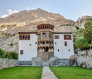
Khaplu, also spelt Khapalu, is a city that serves as the administrative capital of the Ghanche District in Pakistan-administered Gilgit-Baltistan, within the disputed Kashmir region. Located 103 km (64 mi) east of Skardu, Khaplu was historically the second-largest kingdom in Baltistan under the Yabgo dynasty and played a key role in guarding the trade route to Ladakh along the Shyok River, near its confluence with the Indus.

The Shyok River is a tributary of the Indus River that flows through northern Ladakh and enters Gilgit–Baltistan, in Pakistan, spanning some 550 km (340 mi).
Chol Kiri is a district (srok) in the east of Kampong Chhnang province, in central Cambodia. The district capital is Chol Kiri town located around eight km (5.0 mi) south of the provincial capital of Kampong Chhnang by road. Chol Kiri district is the easternmost district of Kampong Chhnang. The district shares a border with Kampong Thom and Kampong Cham provinces to the east. Most of the district is low lying floodplain and the Tonlé Sap River runs through the district roughly from north to south. This proximity to the river and the lack of high land make Chol Kiri one of the most flood prone districts in the country. The Kampong Chhnang Department of Development has estimated that both Chol Kiri and Kampong Leaeng districts are flooded for six months of the year and that after the floodwaters have receded drinking water sources are left contaminated.

The Kir is a river in northern Albania that first flows south-southwest and then southwest out of the North Albanian Alps and enters a distributary of the Drin just below Shkodër.
Khvajeh Geri is a village in Saheli-ye Jokandan Rural District, in the Central District of Talesh County, Gilan Province, Iran. At the 2006 census, its population was 668, in 143 families.

The Thalay Valley, located in the southeastern part of Baltistan within the Ghanche District of Gilgit-Baltistan, Pakistan, is a side valley of Khaplu Valley. The valley ascends from 2,500 meters above sea level to Thalay La, a pass at 4,576 meters. Khasurmik is the northernmost village in Upper Thalay, situated at an altitude of 3,150 meters. Stretching 40 km in length and about 20 km in width, the valley is situated along the Thalla River, which is part of the Shyok Basin. The river converges with the Shyok River at the southern end of the valley, near Daghoni Balgar.
Sermik is a village in Skardu District in the Gilgit-Baltistan region of northeastern Pakistan. it is approx 45 Km away from Skardu.The people of sermik is very kind and Generous ,furthermore sermik is at a great location,it is located approximately in central of District Kharmang, District Ghangche and District Skardu. The people of sermik posses innate intelligence.They have their great history & Cultural heritage. Unequivocally it's among the most beautiful place in Gilgit Baltistan.ie Gorgeous mountains, Captivating culture, largest Artificial forest, The mighty indus river passes from here, Likewise there is also a big stream. Most people grow potato & sells them and earns thousands of rupees from it.Potatoes are perennial plants planted in the spring and harvested in the fall. Similarly people of the Land Looks busy in agricultural works & agrarian.

