
The Karakoram is a mountain range in the Kashmir region spanning the border of Pakistan, China, and India, with the northwestern extremity of the range extending to Afghanistan and Tajikistan. Most of the Karakoram mountain range falls under the jurisdiction of Gilgit-Baltistan, which is located in Pakistan. Its highest peak, K2, is located in Gilgit-Baltistan, Pakistan. It begins in the Wakhan Corridor (Afghanistan) in the west, encompasses the majority of Gilgit-Baltistan, Pakistan and extends into Ladakh and Aksai Chin. It is part of the larger Trans-Himalayan mountain ranges.

Baltistan also known as Baltiyul or Little Tibet, is a mountainous region in the Pakistani-administered territory of Gilgit-Baltistan and constitutes a northern portion of the larger Kashmir region that has been the subject of a dispute between India and Pakistan since 1947. It is located near the Karakoram and borders Gilgit to the west, China's Xinjiang to the north, Indian-administered Ladakh to the southeast, and the Indian-administered Kashmir Valley to the southwest. The average altitude of the region is over 3,350 metres (10,990 ft). Baltistan is largely administered under the Baltistan Division.

Skardu is a city located in Pakistan administered Gilgit-Baltistan in the disputed Kashmir region. Skardu serves as the capital of Skardu District and the Baltistan Division. It is situated at an average elevation of nearly 2,500 metres above sea level in the Skardu Valley, at the confluence of the Indus and Shigar rivers. It is an important gateway to the eight-thousanders of the nearby Karakoram mountain range. The Indus River running through the region separates the Karakoram from the Ladakh Range.
The Baltoro Glacier is a glacier located in the Shigar District of the Gilgit-Baltistan region in Pakistan. It stretches for 63 km (39 mi) in length. It is one of the longest glaciers outside the polar regions. It is home to some of the world’s highest mountains. It runs through the Karakoram mountain range, close to K2, which is the second highest peak in the world, reaching an elevation of 8,611 meters. Within a 20-kilometer radius, there are three more mountains with elevations exceeding 8,000 meters.

Ghanche District is a district of Pakistan-administered Gilgit-Baltistan in the disputed Kashmir region. It is the eastern-most district of Gilgit-Baltistan. It is the coldest place within Pakistan as it is situated on the "third pole", with temperatures reaching below -20 °C in the winter. The Khaplu Valley and the Hushe Valley form the gateway for the great Baltoro Muztagh, the subrange of the Karakoram Mountains that includes the mighty peaks of K2, Broad Peak, the Gasherbrums and Masherbrum ,all of which are also included in the Skardu District).

Gilgit-Baltistan is an administrative territory of Pakistan in the northern part of the country. It was given self-governing status on August 29, 2009. Gilgit-Baltistan comprises 14 districts within three divisions. The four districts of Skardu Kharmang Shigar and Ghanche are in the Baltistan Division, four districts of Gilgit Ghizer Hunza and Nagar districts which were carved out of Gilgit District are in the Gilgit Division and the third division is Diamir, comprising Chilas and Astore. The main political centres are the towns of Gilgit and Skardu.
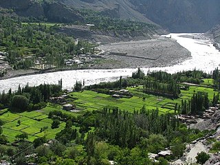
Khaplu, also spelt Khapalu, is a city that serves as the administrative capital of the Ghanche District in Pakistan-administered Gilgit-Baltistan, within the disputed Kashmir region. Located 103 km (64 mi) east of Skardu, Khaplu was historically the second-largest kingdom in Baltistan under the Yabgo dynasty and played a key role in guarding the trade route to Ladakh along the Shyok River, near its confluence with the Indus.

The Shyok River is a tributary of the Indus River that flows through northern Ladakh and enters Gilgit–Baltistan, in Pakistan, spanning some 550 km (340 mi).

The Skardu Valley is located in Gilgit-Baltistan region of Pakistan. The valley is about 10 km wide and 40 km long. It is at the confluence of the Shigar River and Indus River. Surrounded by the giagantic Karakoram and Himalayas ranges and with its nearby lakes, it is an important tourist destination in Pakistan. Skardu is the main town of Baltistan along the wide bank of the river Indus. Skardu is the largest district of the Northern Areas. Baltistan is home to some of the highest peaks in the world, the Karakoram Range, Skardu is very popular with Mountaineering Expeditions. It is equally popular with high altitude trekkers, who treks to Baltoro Glacier, K2 Base Camp and Concordia. Skardu by road, lies approximately 5 hours away from Gilgit and 10 hours drive from Besham.
The Mustagh Pass or Muztagh Pass is a mountain pass across the Baltoro Muztagh subrange within the Karakoram, which includes K2, the world's second highest mountain. The crest of the Baltoro Muztagh marks the present border between Pakistani and Chinese territory. Sarpo Laggo Pass is a 6,013-meter (19,728 ft)-high mountain pass at 35.8234°N 76.16249°E near Mustagh Pass.

Yugo (Yugu) is a small village with a population of more than 6,000 people in the Ghanche district of Baltistan, Gilgit-Baltistan, Pakistan. The village is located above the Shyok River 70 km from Baltistan's capital Skardu on a tarmac highway heading towards Khaplu after passing Ghawari and Kunes. Yugo is situated adjacent to the geographically important village of Kharfak which boasts of a high-altitude mountain lake, Lake Kharfak. Khaplu which is Ghanche district's administrative capital lies a further 25 km away from Yugo.
Balghar is a village situated in Ghanche District, Gilgit Baltistan, Pakistan, along the banks of the Shyok River.

Hassanabad is a naturally beautiful and far flung village existed in Sub-Division Chorbat, Ghangche District of Gilgit-Baltistan, Pakistan, lying 141 kilometres (88 mi) east of Skardu, near the border of India. The village has 270 households and seven Mohallas. The village is backward in all spheres of life.

Chorbat Valley is a section of the Shyok river valley divided between Pakistan-administered Gilgit-Baltistan and Indian-administered Ladakh. The Pakistan-administered portion is in the Khaplu tehsil of Ghanche District in Gilgit–Baltistan, and the Indian-administered portion is in the Nubra tehsil, Leh district of Ladakh. Chorbat stretches from the edge of Khaplu to the Chalunka village of Nubra.
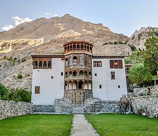
Khaplu Palace, locally known as Yabgo Khar, is an old fort and palace located in Khaplu, a city in Gilgit-Baltistan, Pakistan. The palace, considered an architectural heritage site and a significant tourist attraction, was built in the mid-19th century to replace an earlier-dated fort located nearby. It served as a royal residence for the Raja of Khaplu.
Haldi also Halde or Huldi is a village in Ghanche District of Gilgit-Baltistan, Pakistan. Haldi is a historic village of Baltistan, located at the meeting place of Saltoro river and Hushe River 28 km from district centre Khaplu.
Thagas is a village in Gilgit Baltistan, Pakistan located 32 km (20 mi) from Khaplu in east. It is on the bank of the Saltoro River just before it joins the Shyok River. Thagas is the administrative headquarters of Mashabrum subdivision of Ghanche District.

Tourism in Gilgit-Baltistan, an administered territory of Pakistan, focuses on its access to various mountain ranges and alpine terrain. Various tourist destinations attract millions of travelers from within Pakistan. On the other hand, tourists from other countries also routinely visit GB. An estimated 1.72 million tourists visited the region in 2017 according to the Pakistan Tourism Development Corporation (PTDC). Travelers had contributed Rs.300 million to the local economy in 2017. The authorities were expecting 2.5 million tourists in 2018 which would have meant an additional Rs.450 million to the economy.
Kondos Valley is a valley in the Masherbrum Tehsil of Ghanche District of Gilgit-Baltistan. It shares boundaries with China on the northern side and India on the eastern side. It is 150 km from Skardu and 50 km from Khaplu with its population of approximately 10,000 people. It is located 9,500 feet above sea level.
Siksa is a village in the sub division Chorbat Valley, Ghanche District of Gilgit-Baltistan, lying 150 kilometres (93 mi) east of Skardu, near the border of Pakistan and India at an elevation of 2,725 metres (8,940 ft).


