Khodovarikha

Last updated
Khodovarikha
Ходовариха

Kara seaKV.PNG

Location of Khodovarikha in the Barents Sea shore
Russia edcp location map.svg
Red pog.svg
Location Nenets Autonomous Okrug, Arkhangelsk Oblast,
Russian Federation
Coordinates 68°56′28″N53°46′08″E / 68.941°N 53.769°E / 68.941; 53.769 Coordinates: 68°56′28″N53°46′08″E / 68.941°N 53.769°E / 68.941; 53.769
Offshore water bodies Pechora Sea
Area Arctic

Khodovarikha (Russian : Ходовариха) is a point in the coast of the Pechora Sea located on a landspit projecting eastwards over the bay. Latitude: 68° 57' Longitude: 53° 45' [1] [2]

Russian language East Slavic language

Russian is an East Slavic language, which is official in the Russian Federation, Belarus, Kazakhstan and Kyrgyzstan, as well as being widely used throughout Eastern Europe, the Baltic states, the Caucasus and Central Asia. It was the de facto language of the Soviet Union until its dissolution on 25 December 1991. Although nearly three decades have passed since the breakup of the Soviet Union, Russian is used in official capacity or in public life in all the post-Soviet nation-states, as well as in Israel and Mongolia.

Pechora Sea A marginal sea at the northwest of Russia, the southeastern part of the Barents Sea

Pechora Sea, is a sea at the northwest of Russia, the southeastern part of the Barents Sea. The western border of the sea is off Kolguyev Island, while the eastern border is the western coasts of Vaygach Island and the Yugorsky Peninsula, and the northern border the southern end of Novaya Zemlya.

Contents

Khodovarikha belongs to the Nenets Autonomous Okrug administrative region, which is an autonomous okrug of Arkhangelsk Oblast.

Nenets Autonomous Okrug First-level administrative division of Russia

Nenets Autonomous Okrug is a federal subject of Russia. Its administrative center is the town of Naryan-Mar. It has an area of 176,700 square kilometers (68,200 sq mi) and a population of 42,090 as of the 2010 Census.

Okrug is an administrative division of some Slavic states. The word "okrug" is a loanword in English, but it is nevertheless often translated as "area", "district", or "region".

Arkhangelsk Oblast First-level administrative division of Russia

Arkhangelsk Oblast is a federal subject of Russia. It includes the Arctic archipelagos of Franz Josef Land and Novaya Zemlya, as well as the Solovetsky Islands in the White Sea. Arkhangelsk Oblast also has administrative jurisdiction over Nenets Autonomous Okrug. Including Nenetsia, Arkhangelsk Oblast has an area of 587,400 km2. Its population was 1,227,626 as of the 2010 Census.

History

There is a lighthouse at Khodovarikha that used to be an important beacon for the Russian convoy route coming from the Yugorsky Strait in World War II. It was shelled in 1942 by the Kriegsmarine during Operation Wunderland. The lighthouse ceased operation in 1996.

Yugorsky Strait strait

The Yugorsky Strait or Yugor Strait is a narrow sound between the Kara Sea and the Pechora Sea. Its maximum width is 10 km and its minimum width only 3 km.

World War II 1939–1945 global war

World War II, also known as the Second World War, was a global war that lasted from 1939 to 1945. The vast majority of the world's countries—including all the great powers—eventually formed two opposing military alliances: the Allies and the Axis. A state of total war emerged, directly involving more than 100 million people from over 30 countries. The major participants threw their entire economic, industrial, and scientific capabilities behind the war effort, blurring the distinction between civilian and military resources. World War II was the deadliest conflict in human history, marked by 50 to 85 million fatalities, most of whom were civilians in the Soviet Union and China. It included massacres, the genocide of the Holocaust, strategic bombing, premeditated death from starvation and disease, and the only use of nuclear weapons in war.

<i>Kriegsmarine</i> 1935–1945 naval warfare branch of Germanys armed forces

The Kriegsmarine was the navy of Nazi Germany from 1935 to 1945. It superseded the Imperial German Navy of the German Empire (1871–1918) and the inter-war Reichsmarine (1919–1935) of the Weimar Republic. The Kriegsmarine was one of three official branches, along with the Heer (Army) and the Luftwaffe of the Wehrmacht, the German armed forces from 1933 to 1945.

There was a small populated place close by that has been abandoned. However, there is still a functioning weather station in Khodovarikha. [3]

Weather station set of sensors that record and provide physical measurements and meteorological parameters

A weather station is a facility, either on land or sea, with instruments and equipment for measuring atmospheric conditions to provide information for weather forecasts and to study the weather and climate. The measurements taken include temperature, atmospheric pressure, humidity, wind speed, wind direction, and precipitation amounts. Wind measurements are taken with as few other obstructions as possible, while temperature and humidity measurements are kept free from direct solar radiation, or insolation. Manual observations are taken at least once daily, while automated measurements are taken at least once an hour. Weather conditions out at sea are taken by ships and buoys, which measure slightly different meteorological quantities such as sea surface temperature (SST), wave height, and wave period. Drifting weather buoys outnumber their moored versions by a significant amount.

Khodovarikha was the subject of a 2015 RT documentary Arctic Limbo, chronicling the isolation of the weather station staff.

RT (TV network) Russian government-funded international television network

RT is a Russian international television network funded by the Russian government. It operates pay television channels directed to audiences outside of Russia, as well as providing Internet content in English, Spanish, French, German, Arabic and Russian.

Related Research Articles

Murmansk City in Murmansk Oblast, Russia

Murmansk is a port city and the administrative center of Murmansk Oblast in the far northwest part of Russia. It sits on both slopes and banks of a modest ria or fjord, Kola Bay, an estuarine inlet of the Barents Sea. Its bulk is on the east bank of the inlet. It is in the north of the rounded Kola Peninsula which covers most of the oblast. The city is 108 kilometres (67 mi) from the border with Norway and 182 kilometres (113 mi) from the Finnish border. The city is named for the Murman Coast, an archaic term in Russian for Norway.

Chukotka Autonomous Okrug First-level administrative division of Russia

Chukotka Autonomous Okrug or Chukotka (Чуко́тка) is a federal subject of Russia. It is geographically located in the Far East region of the country, and is administratively part of the Far Eastern Federal District. Chukotka is the 2nd-least-populated federal subject at 50,526 (2010) and the least densely populated.

Yamalo-Nenets Autonomous Okrug First-level administrative division of Russia

Yamalo-Nenets Autonomous Okrug is a federal subject of Russia. Its administrative center is the town of Salekhard, and its largest city is Noyabrsk. Its population was counted to be 522,904 in the 2010 Census.

Khanty-Mansiysk Town in Khanty-Mansi Autonomous Okrug, Russia

Khanty-Mansiysk is a town and the administrative center of Khanty-Mansi Autonomous Okrug, Russia. It is located on the eastern bank of the Irtysh River, 15 kilometers (9.3 mi) from its confluence with the Ob, in the oil-rich region of Western Siberia. Khanty-Mansiysk is an independent city, but is the administrative center of Khanty-Mansiysky District. It was previously known as Ostyako-Vogulsk.

Salekhard Town in Yamalo-Nenets Autonomous Okrug, Russia

Salekhard is a town and the administrative center of Yamalo-Nenets Autonomous Okrug, Russia. It crosses the Polar circle, the main parts being about 1 kilometer (0.62 mi) south and suburbs stretching to the north of the circle. Population: 42,544 (2010 Census); 36,827 (2002 Census); 32,334 (1989 Census).

Pevek Town in Chukotka Autonomous Okrug, Russia

Pevek is an Arctic port town and the administrative center of Chaunsky District in Chukotka Autonomous Okrug, Russia, located on Chaunskaya Bay on a peninsula on the eastern side of the bay facing the Routan Islands, above the Arctic Circle, about 640 kilometers (400 mi) northwest of Anadyr, the administrative center of the autonomous okrug. Population: 4,162 (2010 Census); 5,206 (2002 Census); 12,915 (1989 Census). with an estimated population as at 1 January 2015 of 4,721.

Surgut City in Khanty-Mansi Autonomous Okrug, Russia

Surgut is a city in Khanty-Mansi Autonomous Okrug, Russia, located on the Ob River near its junction with the Irtysh River. It is one of the few cities in Russia to be larger than the capital or the administrative center of its federal subject in terms of population, economic activity, and tourist traffic. Population: 348,643 (2016); 306,675 (2010 Census); 285,027 (2002 Census); 247,823 (1989 Census).

Bilibino Town in Chukotka Autonomous Okrug, Russia

Bilibino is a town and the administrative center of Bilibinsky District in Chukotka Autonomous Okrug, Russia, located at the confluence of the Karalveyem and Bolshoy Keperveyem Rivers, 625 kilometers (388 mi) northwest of Anadyr, the administrative center of the autonomous okrug. With a population of 5,506 as of the 2010 Census, and an estimated population as of 1 January 2015 of 5,592, it is the second largest town in the autonomous okrug after Anadyr.

Bely Island island

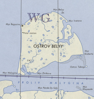
Bely Island is a relatively large island in the Kara Sea off the tip of the Yamal Peninsula, Siberia, Russia. Close to the island's northwest tip, there is the Russian Experiment Station Popov Station.

Dikson (urban-type settlement) Urban-type settlement in Krasnoyarsk Krai, Russia

Dikson is an urban locality in Taymyrsky Dolgano-Nenetsky District of Krasnoyarsk Krai, Russia. It is a port on the Kara Sea, located on a headland at the mouth of the Yenisei Gulf, on Russia's Arctic Ocean coast. As of the 2010 Census, its population was 676.

Dolgy Island island

Dolgy Island is an island in the Pechora Sea, east of the Khaypudyr Bay. The landscape of the island is relatively flat with small lakes and tundra patches.

Operation Wunderland conflict

Operation Wunderland was a large-scale operation undertaken in summer 1942 by the Kriegsmarine in the waters of the Northern Sea Route close to the Arctic Ocean. The Germans knew that many ships of the Soviet Navy had sought refuge in the Kara Sea because of the protection that its ice pack provided during 10 months of the year.

Mys Shmidta Urban-type settlement in Chukotka Autonomous Okrug, Russia

Mys Shmidta is an urban locality in Iultinsky District of Chukotka Autonomous Okrug, Russia, located about 5 kilometers (3 mi) southeast of the cape of the same name on the shore of the Chukchi Sea, south of Wrangel Island, about 650 kilometers (400 mi) from Anadyr, the administrative center of the autonomous okrug. The cape, but not the settlement, was formerly known as North Cape. Cape Billings is located to the west of it and Cape Vankarem is to the east. As of the 2010 Census, its population was 492; down from 705 recorded in the 2002 Census.

Bilibino Nuclear Power Plant

The Bilibino Nuclear Power Plant is a power plant in Bilibino, Chukotka Autonomous Okrug, Russia. The plant is equipped with four EGP-6 reactors. The plant is the smallest and the northernmost operating nuclear power plant in the world. Plans to begin a shutdown procedure of the plant in 2019 have been announced, and it will be replaced by the floating nuclear power station Akademik Lomonosov.

Iultinsky District is an administrative and municipal district (raion), one of the six in Chukotka Autonomous Okrug, Russia. It is located in the northeast of the autonomous okrug and borders with the Chukchi Sea in the north, Providensky District in the east, Gulf of Anadyr in the southeast, and with Anadyrsky District in the southwest. The area of the district is 134,600 square kilometers (52,000 sq mi). Its administrative center is the urban locality of Egvekinot. Population: 4,329 (2010 Census); 3,974 (2002 Census); 15,689 (1989 Census). The population of Egvekinot accounts for 64.4% of the district's total population.

Apapelgino Selo in Chukotka Autonomous Okrug, Russia

Apapelgino is a rural locality in Chaunsky District of Chukotka Autonomous Okrug, Russia, located just to the east of Pevek, on the northeastern shores of Chaunskaya Bay. As of June 2005, its population was estimated to be five people.

Zapolyarny District District in Nenets Autonomous Okrug, Russia

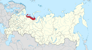
Zapolyarny District is an administrative and municipal district (raion), the only one in Nenets Autonomous Okrug, Russia. It encompasses all of the territory of the autonomous okrug, with the exception of the territory of the town of okrug significance of Naryan-Mar, the only other top-level administrative division of the autonomous okrug. The area of the district is approximately 170,000 square kilometers (66,000 sq mi). Its administrative center is the urban locality of Iskateley. Population: 20,432. The population of Iskateley accounts for 33.7% of the district's total population.

Northern Fleet Joint Strategic Command (Russia)

The Northern Fleet Joint Strategic Command, is a military command of Russia.

Sabetta International Airport airport in Russia

Sabetta International Airport is an airport in Sabetta, Yamalo-Nenets Autonomous Okrug, Russia.

References

  1. Location
  2. "Khodovarikha". Mapcarta. Retrieved 23 September 2016.
  3. Simon Bowcock (October 26, 2015). "Slava of the Arctic: the world's most extreme weatherman". The Guardian. Retrieved October 26, 2015.