
The Karakash or Black Jade River, also spelled Karakax, is a river in the Xinjiang autonomous region of the People's Republic of China that originates in Aksai Chin. It passes through the historical settlement of Xaidulla and passes by the city of Khotan (Hotan) to flow northeast in the Tarim Basin. It merges with the Yurungkash River, the combined river taking the name Hotan River and flowing into the Tarim River.

Hotan is a major oasis town in southwestern Xinjiang, an autonomous region in Western China. The city proper of Hotan broke off from the larger Hotan County to become an administrative area in its own right in August 1984. It is the seat of Hotan Prefecture.
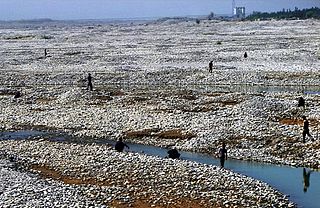
The White Jade River, also known by the native names Baiyu or Yurungkash, is a river in the southern Xinjiang region of China.
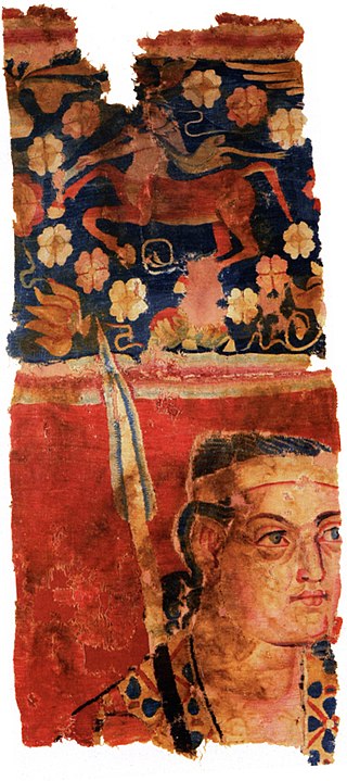
The Sampul tapestry is an ancient woolen wall-hanging found at the Tarim Basin settlement of Sampul in Lop County, Hotan Prefecture, Xinjiang, China, close to the ancient city of Khotan. The object has many Hellenistic period features, including a Greek centaur and diadem, linking it to the Greco-Bactrian Kingdom. It may represent a Yuezhi soldier, in red jacket and trousers, from the 1st century CE. Alternatively, the soldier (king) is possibly a Greco-Bactrian, an Hellenized Saka or a Greco-Saka military aristocrat. The man's head features and the spear representation are modeled similarly with the depiction of Alexander the Great on a medallion found from Roman Egypt and could represent the king. Overall, the Sampul tapestry belongs to the Greco-Bactrian culture.

Niya County, also from Mandarin Chinese as Minfeng County, is a county within the Xinjiang Uyghur Autonomous Region and is under the administration of the Hotan Prefecture. It contains an area of 56,726 km2 (21,902 sq mi). According to the 2002 census, it has a population of 30,000. The county is bordered to the north by Xayar County, to the east by Qiemo/Qarqan County, to the west by Yutian / Keriya County and to the south by Ngari Prefecture in Tibet.

Yutian County, also transliterated from Uyghur as Keriya County, is a county in Hotan Prefecture, Xinjiang Uyghur Autonomous Region, China. It is based at the Keriya Town, and is separate from Hotan County, which is another county in the same prefecture. The Yutian County has an area of 39,023 km2 (15,067 sq mi). According to the 2002 census, it has a population of 220,000. The county is bounded on the north by Aksu Prefecture, on the east by Minfeng/Niya County, on the west by Qira County and on the south by the Rutog and Gertse counties of the Tibet Autonomous Region.

Lop County, also Luopu, is a county in Hotan Prefecture, in the southwest of the Xinjiang Uyghur Autonomous Region, China. Almost all the residents of the county are Uyghur and live around oases situated between the desolate Taklamakan Desert and Kunlun Mountains. The county is bordered to the north by Aksu and Awat County in Aksu Prefecture, to the east by Qira/Chira County, to the northwest by Karakax County, to the west by Hotan (Khotan) and to the south and west by Hotan County.

Hotan County is a county in the southwest of the Xinjiang Uyghur Autonomous Region and is under the administration of the Hotan Prefecture. Almost all the residents of the county are Uyghurs and live around oases situated between the desolate Taklamakan Desert and Kunlun Mountains. Hotan County is the southernmost county-level division of Xinjiang. The county borders Karakax/Moyu County to the northwest, Hotan City and Lop County to the northeast, Qira County to the east, Pishan County to the west, and Rutog County, Tibet to the southeast. Hotan County administers most of Aksai Chin, an area disputed between China and India. The Line of Actual Control divides the India-controlled part of Ladakh union territory from the Aksai Chin area administered as part of southwest Hotan County.

Hotan Prefecture is located in the Tarim Basin region of southwestern Xinjiang, China, bordering the Tibet Autonomous Region to the south and Union Territory of Ladakh and Gilgit-Baltistan to the west. The vast majority of the Aksai Chin region which is disputed between China and India is administered as part of Hotan Prefecture. The seat of Hotan Prefecture is Hotan and its largest county by population is Karakax County. The vast majority of the residents of the prefecture are Muslim Uyghurs and live around oases situated between the desolate Taklamakan Desert and Kunlun Mountains.
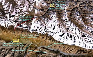
Hindu-tagh Pass, also known as Hindutash, is a historical mountain pass in the western Xinjiang, China. The pass cuts through the Kunlun Mountains connecting the now-deserted town of Kangxiwar in the Karakash River valley to the town of Pusha in the Pusha Jilga valley. It also connects to the road to the city of Hotan.
Gumma or Guma may refer to:
He Tian or Hetian may refer to:

The Turpan–Hotan Expressway (Chinese: 吐鲁番—和田高速公路, Uyghur: تۇرپان-خوتەن يۇقىرى سۈرئەتلىك تاشيولى), commonly referred to as the Tuhe Expressway (Chinese: 吐和高速公路), is a Chinese expressway that connects the G30 Lianyungang–Khorgas Expressway at Xiaocaohu, in Toksun County, Turpan, with China National Highway 315 in Lop County, Hotan Prefecture. The expressway, designated G3012, is a spur of the G30 Lianyungang–Khorgas Expressway and is completely in Xinjiang. It is 1,931 kilometres (1,200 mi) in length, which is unusually long for an expressway under a single sub-national administration, being vastly longer than Interstate 10 in Texas.
Kunyu is a county-level city in Xinjiang Uyghur Autonomous Region, China. It is geographically located in Hotan Prefecture of Southern Xinjiang, but is de jure directly administered by the Xinjiang regional government.