Related Research Articles
Telegraph Creek is a small community located off Highway 37 in northern British Columbia at the confluence of the Stikine River and Telegraph Creek. The only permanent settlement on the Stikine River, it is home to approximately 250 members of Tahltan First Nation and non-native residents. The town offers basic services, including Anglican and Catholic churches, a general store, a post office, a clinic with several nurses on-call around the clock, two Royal Canadian Mounted Police officers, and a K-9 school. Steep river banks and rocky gorges form the terraced nature of the geography.

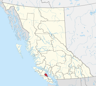
Khutzeymateen Inlet is one of the lesser principal inlets of the British Columbia Coast. It is important in being part of the first area in Canada protected to preserve grizzly bears and their habitat via the Khutzeymateen/K’tzim-a-deen Grizzly Sanctuary. The inlet and the park-sanctuary surrounding it are between the mouths of the Skeena and Nass Rivers; the Khutzeymateen is the next inlet north from Work Channel, which is the north side of the Tsimpsean Peninsula of "Greater Prince Rupert". The inlet's mouth opens onto an arm of Portland Inlet, Steamer Passage, which lies next to Sommerville Island. The entrance to Khutzeymateen Inlet is between Keemein Point and Welgeegenk Point. The closest community is Lax Kw'alaams, formerly Port Simpson.

Princess Royal Island is the largest island on the North Coast of British Columbia, Canada. It is located amongst the isolated inlets and islands east of Hecate Strait on the British Columbia Coast. At 2,251 square kilometres (869 sq mi), it is the fourth largest island in British Columbia. It was named in 1788 by Captain Charles Duncan, after his ship Princess Royal.

Parts of this article have been adapted from the BC Parks website.
Khutzeeymateen Provincial Park, also known as Khutzeymateen/K'tzim-A-Deen Grizzly Sanctuary, is a Class A provincial park located in the North Coast region of British Columbia, Canada. The park, within the purview of BC Parks, was established on August 15, 1994, to protect critical habitat for the region's grizzly bear population and the largest contiguous stand of old-growth Sitka spruce in the world. It was officially opened by Prince Philip, Duke of Edinburgh, on August 17, 1994.
Kluskoil Lake Provincial Park is a provincial park in British Columbia, Canada, located on the West Road River downstream from the Euchiniko Lakes.

Shuswap Lake Provincial Park is a provincial park in British Columbia, Canada.
Tranquil Creek Provincial Park is a provincial park in British Columbia, Canada, located at the head of the Kennedy River, east of the head of Bedwell Sound on Vancouver Island.

Indian Arm is a steep-sided glacial fjord adjacent to the city of Vancouver in southwestern British Columbia. Formed during the last Ice Age, it extends due north from Burrard Inlet, between the communities of Belcarra and the District of North Vancouver, then on into mountainous wilderness. Burrard Inlet and the opening of Indian Arm was mapped by Captain George Vancouver and fully explored days later by Dionisio Alcalá Galiano in June 1792.

The Squamish Nation, Sḵwx̱wú7mesh Úxwumixw in Sḵwx̱wú7mesh Sníchim, is an Indian Act government originally imposed on the Squamish (Sḵwx̱wú7mesh) by the Federal Government of Canada in the late 19th century. The Squamish are Indigenous to British Columbia, Canada. Their band government comprises 8 elected councillors, serving four-year terms, with an elected band manager. Their main reserves are near the town of Squamish, British Columbia and around the mouths of the Capilano River, Mosquito Creek, and Seymour River on the north shore of Burrard Inlet in North Vancouver, British Columbia.
The Lower Similkameen Indian Band or Lower Smelqmix, is a First Nations band government in the Canadian province of British Columbia. Their office was in the village of Keremeos in the Similkameen region, until 2015 when they moved into their own $7million multi-purpose facility south of Cawston. They are a member of the Okanagan Nation Alliance.
The Stone First Nation or Yunesitʼin First Nation is a band government of the Yunesit'in subgroup of the Tsilhqot'in people, whose territory is the Chilcotin District in the western Central Interior region of the Canadian province of British Columbia. It is a member of the Tsilhqot'in Tribal Council. The people of the Stone First Nation are known as the Yunesit'in in the Chilcotin language.

The Fannin Range is a small mountain range in the Pacific Ranges of the Coast Mountains of British Columbia, Canada. Lying between the Seymour River and the glacial fjord Indian Arm, the range extends from the slopes of Mount Seymour on the Burrard Inlet to the district of North Vancouver more than 34 kilometres north to the headwaters of the Indian River. It is named after the naturalist John Fannin It is commonly considered to be part of the North Shore Mountains.
The Comox Valley Regional District is a regional district in British Columbia, Canada. It was created on February 15, 2008, encompassing the southeastern portions of the former Regional District of Comox-Strathcona, and centred about the Comox Valley. The partition left the new Comox Valley Regional District with only 8.4 percent of the former Comox-Strathcona's land area, but 57.9 percent of its population. The CVRD covers an area of 2,425 square kilometres, of which 1,725 square kilometres is land, and serves a population of 66,527 according to the 2016 Census. The district borders the Strathcona Regional District to the northwest, the Alberni-Clayoquot Regional District to the southwest, and the Regional District of Nanaimo to the southeast, as well as the qathet Regional District along the Strait of Georgia to the east.
The Nazko First Nation is a First Nations government of the Dakelh people in the north-central Interior of British Columbia. Its reserves are located around the community of Nazko, British Columbia, which is 120 km west of Quesnel and southwest of Prince George.
ḵ’els is a mountain located at the head of lekw’emin above the ancestral shíshálh village site of x̱enichen and within the Pacific Ranges of the Coast Mountains of British Columbia, Canada. The mountain is associated with a shíshálh legend about a great flood.
The Tahltan First Nation, also known as the Tahltan Indian Band, is a band government of the Tahltan people. Their main community and reserves are located at Telegraph Creek, British Columbia. Their language is the Tahltan language, which is an Athabaskan language also known as Nahanni, is closely related to Kaska and Dunneza. Their Indian and Northern Affairs Canada band number is 682. The Tahltan First Nation is joined with the Iskut First Nation in a combined tribal council-type organization known as the Tahltan Nation.
Wakeman Sound is a sound on the South Coast of British Columbia, Canada, located in the area north of the Broughton Archipelago, which lies on the north side of Queen Charlotte Strait, on the northeast side of Broughton Island. It is a sidewater opening of and opening north off Kingcome Inlet.
The Hartley Bay Indian Band is also known as the Gitga'at First Nation or the Hartley Bay First Nation. The members of the Gitga'at First nation are often referred to as Gitka'a'ata. The population of Gitk’a’ata peoples living in Hartley Bay ranges from approximately 130-200 people. There are also about 400-500 Gitk’a’ata peoples living in Prince Rupert, British Columbia, Canada, a neighboring territory. The Gitk’a’ata people have lived in Hartley Bay for hundreds of years, if not always. Some notable things regarding the Gitga'at First Nation are their economy, geography, government, sports involvement, COVID-19 regulations, and relations.
The Kateen River is a river in the Kitimat Ranges of the North Coast region of British Columbia, flowing southwest into the Khutzeymateen River a few miles before its entry to the sea at the head of Khutzeymateen Inlet. The river is within Khutzeymateen Provincial Park.
References
- ↑ "BC Geographical Names". apps.gov.bc.ca.
- ↑ "BC Geographical Names". apps.gov.bc.ca.
- ↑ "BC Geographical Names". apps.gov.bc.ca.
- ↑ "BC Geographical Names". apps.gov.bc.ca.
- ↑ "BC Geographical Names". apps.gov.bc.ca.
- ↑ "BC Geographical Names". apps.gov.bc.ca.
- ↑ "English title / Titre en anglais". Crown–Indigenous Relations and Northern Affairs Canada . Government of Canada. Retrieved 2014-05-07.
| International | |
|---|---|
| National | |
54°37′31″N129°54′00″W / 54.62528°N 129.90000°W