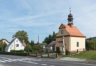
Święcko is a village in the administrative district of Gmina Kłodzko, within Kłodzko County, Lower Silesian Voivodeship, in south-western Poland. Prior to 1945 it was in Germany. It lies approximately 9 kilometres (6 mi) north-west of Kłodzko and 77 km (48 mi) south-west of the regional capital Wrocław.

Błotka is a village in the administrative district of Gmina Zławieś Wielka, within Toruń County, Kuyavian-Pomeranian Voivodeship, in north-central Poland. It lies approximately 9 km (6 mi) west of Toruń.

Khandzadzor is a village in the Hadrout region of Republic of Artsakh.
Stara Gazomia is a village in the administrative district of Gmina Moszczenica, within Piotrków County, Łódź Voivodeship, in central Poland.

Grotowice is a village in the administrative district of Gmina Rzeczyca, within Tomaszów Mazowiecki County, Łódź Voivodeship, in central Poland. It lies approximately 5 kilometres (3 mi) east of Rzeczyca, 25 km (16 mi) east of Tomaszów Mazowiecki, and 65 km (40 mi) east of the regional capital Łódź.

Łęg is a village in the administrative district of Gmina Rzeczyca, within Tomaszów Mazowiecki County, Łódź Voivodeship, in central Poland. It lies approximately 3 kilometres (2 mi) south-east of Rzeczyca, 23 km (14 mi) east of Tomaszów Mazowiecki, and 63 km (39 mi) east of the regional capital Łódź.

Qian County or Qianxian is a county under the administration of the prefecture-level city of Xianyang, in the central part of Shaanxi province, China.

Szczonów is a village in the administrative district of Gmina Żerków, within Jarocin County, Greater Poland Voivodeship, in west-central Poland. It lies approximately 7 kilometres (4 mi) north of Żerków, 19 km (12 mi) north of Jarocin, and 55 km (34 mi) south-east of the regional capital Poznań.

Mokrus is a village in the administrative district of Gmina Ogrodzieniec, within Zawiercie County, Silesian Voivodeship, in southern Poland. It lies approximately 9 kilometres (6 mi) north-east of Ogrodzieniec, 14 km (9 mi) east of Zawiercie, and 51 km (32 mi) north-east of the regional capital Katowice.

Przychody is a village in the administrative district of Gmina Pilica, within Zawiercie County, Silesian Voivodeship, in southern Poland. It lies approximately 7 kilometres (4 mi) north-east of Pilica, 23 km (14 mi) east of Zawiercie, and 59 km (37 mi) north-east of the regional capital Katowice.

Chojnaty is a village in the administrative district of Gmina Chojnice, within Chojnice County, Pomeranian Voivodeship, in northern Poland. It lies approximately 4 kilometres (2 mi) south-east of Chojnice and 103 km (64 mi) south-west of the regional capital Gdańsk.

Moszczenica is a village in the administrative district of Gmina Chojnice, within Chojnice County, Pomeranian Voivodeship, in northern Poland. It lies approximately 8 kilometres (5 mi) south-west of Chojnice and 110 km (68 mi) south-west of the regional capital Gdańsk.

Śluza is a settlement in the administrative district of Gmina Chojnice, within Chojnice County, Pomeranian Voivodeship, in northern Poland. It lies approximately 24 kilometres (15 mi) north of Chojnice and 90 km (56 mi) south-west of the regional capital Gdańsk.

Linowiec is a village in the administrative district of Gmina Starogard Gdański, within Starogard County, Pomeranian Voivodeship, in northern Poland. It lies approximately 7 kilometres (4 mi) north-west of Starogard Gdański and 40 km (25 mi) south of the regional capital Gdańsk.

Motarzewo is a village in the administrative district of Gmina Czaplinek, within Drawsko County, West Pomeranian Voivodeship, in north-western Poland. It lies approximately 11 kilometres (7 mi) south-east of Czaplinek, 39 km (24 mi) east of Drawsko Pomorskie, and 119 km (74 mi) east of the regional capital Szczecin.

Trzynik is a village in the administrative district of Gmina Siemyśl, within Kołobrzeg County, West Pomeranian Voivodeship, in north-western Poland. It lies approximately 5 kilometres (3 mi) south-east of Siemyśl, 18 km (11 mi) south of Kołobrzeg, and 93 km (58 mi) north-east of the regional capital Szczecin.

Wieńkowo is a village in the administrative district of Gmina Police, within Police County, West Pomeranian Voivodeship, in north-western Poland, close to the German border. It lies approximately 7 kilometres (4 mi) north-west of Police and 20 km (12 mi) north of the regional capital Szczecin.

Łężek is a settlement in the administrative district of Gmina Postomino, within Sławno County, West Pomeranian Voivodeship, in north-western Poland. It lies approximately 8 kilometres (5 mi) west of Postomino, 16 km (10 mi) north of Sławno, and 179 km (111 mi) north-east of the regional capital Szczecin.

Firuzeh County is a county in Razavi Khorasan Province in Iran. The capital of the county is Firuzeh. It was known as That-e Jolgeh previously. It was separated from Nishapur County in April 2010. At the 2006 census, its population was 49,823, in 12,581 families. The county has two districts: Central District and Taghenkoh District. The county has two cities: Firuzeh and Hemmatabad.
Mikhalova is a Minsk Metro station. It was opened on November 7, 2012 along with the metro stations of Hrushawka and Pyatrowshchyna.


