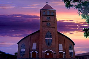
Kibungo city | |
---|---|
Town and sector | |
Coordinates: 2°08′57″S30°32′52″E / 2.14910°S 30.54780°E | |
Country | Rwanda |
Province | Eastern Province |
District | Ngoma District |
Area | |
• Town and sector | 43.37 km2 (16.75 sq mi) |
Elevation | 1,820 m (5,970 ft) |
Population (2022 census) [1] | |
• Town and sector | 31,445 |
• Density | 730/km2 (1,900/sq mi) |
• Urban | 17,087 |
Climate | Aw |
Kibungo is a town and sector in the Republic of Rwanda. It is the political, administrative and commercial capital of Ngoma District. In 1998, Kibungo became the site of at least four of Rwanda's last 22 executions. All of the convicts were executed for crimes related to the 1994 genocide. [2]
Kibungo is located in Ngoma District, Eastern Province. Its location lies in the southeastern part of Rwanda, along the main road (B3) from Kigali in Rwanda, to Nyakasanza, in Tanzania. Kibungo lies approximately 73 kilometres (45 mi) by road southeast of Kigali, the capital and largest city of Rwanda. [3]
Climate data for Kibungo (1991–2020) | |||||||||||||
---|---|---|---|---|---|---|---|---|---|---|---|---|---|
Month | Jan | Feb | Mar | Apr | May | Jun | Jul | Aug | Sep | Oct | Nov | Dec | Year |
Record high °C (°F) | 33.8 (92.8) | 33.1 (91.6) | 31.7 (89.1) | 30.6 (87.1) | 31.4 (88.5) | 30.6 (87.1) | 30.1 (86.2) | 31.5 (88.7) | 32.0 (89.6) | 32.3 (90.1) | 31.2 (88.2) | 33.5 (92.3) | 33.8 (92.8) |
Mean daily maximum °C (°F) | 26.7 (80.1) | 26.8 (80.2) | 26.2 (79.2) | 25.5 (77.9) | 25.7 (78.3) | 26.6 (79.9) | 27.1 (80.8) | 27.5 (81.5) | 27.7 (81.9) | 26.5 (79.7) | 25.5 (77.9) | 26.1 (79.0) | 26.5 (79.7) |
Daily mean °C (°F) | 20.9 (69.6) | 21.0 (69.8) | 20.6 (69.1) | 20.3 (68.5) | 20.4 (68.7) | 20.8 (69.4) | 21.0 (69.8) | 21.4 (70.5) | 21.5 (70.7) | 20.9 (69.6) | 20.2 (68.4) | 20.7 (69.3) | 20.8 (69.4) |
Mean daily minimum °C (°F) | 15.1 (59.2) | 15.2 (59.4) | 15.0 (59.0) | 15.0 (59.0) | 15.1 (59.2) | 15.0 (59.0) | 15.0 (59.0) | 15.3 (59.5) | 15.2 (59.4) | 15.2 (59.4) | 15.0 (59.0) | 15.3 (59.5) | 15.1 (59.2) |
Record low °C (°F) | 9.0 (48.2) | 10.4 (50.7) | 9.9 (49.8) | 9.7 (49.5) | 9.6 (49.3) | 10.7 (51.3) | 9.4 (48.9) | 10.2 (50.4) | 10.6 (51.1) | 10.6 (51.1) | 10.9 (51.6) | 9.8 (49.6) | 9.0 (48.2) |
Average precipitation mm (inches) | 78.8 (3.10) | 97.1 (3.82) | 156.1 (6.15) | 177.9 (7.00) | 127.6 (5.02) | 16.6 (0.65) | 12.7 (0.50) | 42.1 (1.66) | 69.0 (2.72) | 121.2 (4.77) | 197.9 (7.79) | 119.7 (4.71) | 1,216.8 (47.91) |
Average precipitation days (≥ 1.0 mm) | 6.7 | 7.3 | 10.6 | 14.7 | 7.4 | 1.4 | 0.7 | 2.5 | 5.6 | 9.1 | 17.0 | 10.4 | 93.4 |
Source: NOAA [4] |
As of the census of 2022, the population of Kibungo Sector was at 31,445. [1]
Kigali is the capital and largest city of Rwanda. It is near the nation's geographic centre in a region of rolling hills, with a series of valleys and ridges joined by steep slopes. As a primate city, Kigali is a relatively new city. It has been Rwanda's economic, cultural, and transport hub since it was founded as an administrative outpost in 1907, and became the capital of the country at independence in 1962, shifting focus away from Huye.
Rwamagana is a city and capital of both the Rwamagana District and the Eastern Province in Rwanda
Muhanga is a city in Rwanda, in the Muhanga District, in Southern Province. The city is situated 5,945 feet (1,812 m) above sea level.
Eastern Province is the largest, the most populous and the least densely populated of Rwanda's five provinces. It was created in early January 2006 as part of a government decentralization program that re-organized the country's local government structures.
Ngoma is a district (akarere) in Eastern Province, Rwanda. Its capital is Kibungo.
Nyagatare is a town in the North East of Rwanda. With a population of more than 100,000, it is one of the most populous settlements in the Eastern Province along with Rwamagana and Kibungo.
Nyagatare is the largest and second most populous district (akarere) in Rwanda. Located in Eastern Province, Rwanda, it occupies the northeastern extremity of Rwanda. Its capital is Nyagatare City, the former capital of the now defunct Umutara province. Nyagatare District borders Uganda in the North, Tanzania in the East, Gatsibo District of the in the South, and Gicumbi District of the Northern Province in the West. Nyagatare has an area of 1741 km2, what makes it the largest district in Rwanda. With a population of 466,944 in 2012, and 653,861 in 2022, Nyagatare is the second most populated district of Rwanda only after Gasabo District of Kigali City with 879,505 inhabitants. This is a 156% increase from 2002 when the population was only 255,104. This sharp rise in the population is mainly due to the major movement of the population from other parts of the country in search of land.
Nyanza is a district (akarere) in Southern Province, Republic of Rwanda. Its capital is Nyanza town, which is also the provincial capital. Nyanza is a Bantu word meaning lake, which probably refers to the small body of water created by a dam to the west of Nyanza town and sometimes referred to by the local residents as “Ikiyaga” or lake. which probably refers to a large lake to the west of Nyanza city.
Ngororero is a sector and town in Rwanda.
I&M Bank Rwanda Plc., is a commercial bank in Rwanda that is licensed by the National central Bank of Rwanda(central bank). It is the second largest bank in Rwanda.
Guaranty Trust Bank (Rwanda) plc, commonly referred to as GTBank Rwanda, is one of the licensed commercial banks in the Republic of Rwanda. It has been part of Nigerian Guaranty Trust Bank since 2013.
Nyamata is a town and sector in the Bugesera District, southeastern Rwanda. Nyamata literally means 'place of milk' from the two Kinyarwanda words nya- 'of' and amata 'milk'. It is the location of the Nyamata Genocide Memorial, commemorating the Rwandan genocide of 1994.
Bugarama is a town in western Rwanda.
Gatuna is a small settlement in Cyumba Sector in northern Rwanda. It is located at the northern border adjacent to the town of Katuna, in neighboring Uganda.
Kabarore is a town and sector in Rwanda. It is the headquarters of Gatsibo District.
Nemba is a settlement in Rwanda.
Zigama Credit and Savings Bank (ZCSB), is a microfinance bank in Rwanda. The bank is one of the financial institutions licensed by the National Bank of Rwanda, the national banking regulator.
The Rusumo Hydroelectric Power Station, also known as the Rusumo Power Station, is an operational hydropower plant, with initial capacity installation of 80 megawatts (110,000 hp). The project involved the construction of a dam, with run of river design. A more expensive 90 megawatts (120,000 hp) reservoir design was considered before being abandoned in favor of an 80 MW project with a smaller environmental impact and an estimated cost of US$300 million compared to US$400 million for the bigger project.
Kagitumba is a town in Rwanda. It is located at the extreme North Eastern extremity at the confluence of the Kagitumba River and Akagera River. This location is also the tri-point border between Rwanda, Uganda and Tanzania.
Kabarondo is a town and sector in the Republic of Rwanda.