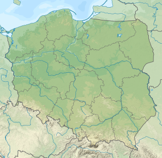
The Kiehnmoor is a nature reserve in Germany. It was designated as a nature reserve in 1992. It has an area of 440 hectares (1,100 acres) of which 100 hectares (250 acres) lie in Celle district and 340 hectares (840 acres) in Uelzen district. The nature conservation authorities of these districts are responsible for the reserve. A large part of the area is wet meadow, that in places is intensively farmed. However the majority of the area has been left in its natural state. A small sand heath forms part of the reserve. Its southern perimeter borders immediately on the larger heathland area of the Südheide Nature Park. The Heidschnucken , moorland sheep characteristic of the region, are reared here. North of the Kiehnmoor and immediately adjacent to it is the valley of a partially dammed stream, the Gerdau, and the Brambosteler Moor nature reserve. To the southeast the reserve borders on the Unterlüß Firing Range (Schießplatz Unterlüß), belonging to the firm of Rheinmetall, and the Große Heide ("Large Heath") near Unterlüß, that is closed to the public. Kiehnmoor, too, is totally out-of-bounds. This whole area is very secluded. Rare birds have settled here including the crane and the black stork. Even the otter may be found here.

A nature reserve is a protected area of importance for flora, fauna or features of geological or other special interest, which is reserved and managed for conservation and to provide special opportunities for study or research. Nature reserves may be designated by government institutions in some countries, or by private landowners, such as charities and research institutions, regardless of nationality. Nature reserves fall into different IUCN categories depending on the level of protection afforded by local laws. Normally it is more strictly protected than a nature park.

The Südheide Nature Park is a large protected area of forest and heathland in the southern part of the Lüneburg Heath in North Germany. It has been designated as a protected nature park since 1964.
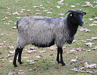
The Heidschnucke is a group of three types of moorland sheep from northern Germany. Like a number of other types from Scandinavia and Great Britain, they are Northern European short-tailed sheep. The three breeds of Heidschnucke are:
Contents
Due to its seclusion, the good supply of nutrients and the space, the relatively natural stands of wood (partly alder and birch fen woods) create an important habitat for black grouse, a species which is very susceptible to disturbance and is threatened by extinction. [1] Together with neighbouring and the largely contiguous areas of the Munster and Bergen-Hohne Training Areas, the Großes Moor bei Becklingen, the marshes near Sittensen, [2] the Ostenholz Moor and the Meißendorf Lakes, this part of the Lüneburg Heath is home to the largest single colony of black grouse on the North German Plain.

A fen is one of the main types of wetland, the others being grassy marshes, forested swamps, and peaty bogs. Along with bogs, fens are a kind of mire. Fens are minerotrophic peatlands, usually fed by mineral-rich surface water or groundwater. They are characterised by their distinct water chemistry, which is pH neutral or alkaline, with relatively high dissolved mineral levels but few other plant nutrients. They are usually dominated by grasses and sedges, and typically have brown mosses in general including Scorpidium or Drepanocladus. Fens frequently have a high diversity of other plant species including carnivorous plants such as Pinguicula. They may also occur along large lakes and rivers where seasonal changes in water level maintain wet soils with few woody plants. The distribution of individual species of fen plants is often closely connected to water regimes and nutrient concentrations.

The black grouse or blackgame or blackcock is a large game bird in the grouse family. It is a sedentary species, breeding across northern Eurasia in moorland and bog areas near to woodland, mostly boreal. The black grouse is closely related to the Caucasian grouse.

Munster Training Area is a military training area in Germany on the Lüneburg Heath. It comprises two separate areas with different purposes: Munster North (Munster-Nord) and Munster South (Munster-Süd). The two areas are separated geographically by the town of Munster and several barracks. When the military training area was established a camp or Lager was built about 1.5 kilometres from the town centre which became known as Munsterlager. Between Munster North and South there is a road corridor to the nearby training area of Bergen-Hohne over which exercising troops can transfer from one area to the other. There are many rare and endangered plant species on this terrain today that thrive in the environment created by the training area.
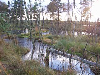
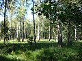 Birch fen wood, Kiehnmoor and Brambosteler Moor
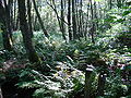 Alder fen wood, Kiehnmoor and Brambosteler Moor