Kieta

Last updated
Kieta
Arawa-Kieta.png
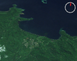
The city of Arawa, and the port of Kieta, from space
Location map Bourgainville Island.png
Red pog.svg
Kieta
Location within Bougainville Island
Coordinates: 06°12′57″S155°37′58″E / 6.21583°S 155.63278°E / -6.21583; 155.63278 Coordinates: 06°12′57″S155°37′58″E / 6.21583°S 155.63278°E / -6.21583; 155.63278
Country Papua New Guinea
Province Bougainville
District Central Bougainville
LLG Arawa Rural LLG
Time zone UTC+10 (AEST)
Location12 km (7.5 mi) from Arawa
Mean max temp32 °C (90 °F)
Mean min temp23 °C (73 °F)
Annual rainfall3,037 mm (119.6 in)

Kieta is a port town located on the eastern coast of the island of Bougainville in Papua New Guinea, near the township of Arawa. After extensive destruction during the 1990 Civil Uprising on Bougainville, Kieta has few inhabitants now, and is known mainly for its transport connections (wharf and airfield).

Contents

History

On 17 May 1885, agreements were made between Germany and the United Kingdom over the islands of Bougainville and Buka in the area of the German sphere of interest. On 20 September 1905 a station was built with a post office and customs. Since 1902, there was a Catholic mission station in Kieta. [1]

Kieta was occupied by the Japanese during the Second World War.

The majority of the town was destroyed in the 1990 Civil Uprising on Bougainville. [2] [3] The airfield has a 5,400 feet (1,600 m) runway which was used by the Japanese in World War II, and was recently serviced by Air Niugini until 1990. For some time after that the only aircraft to service the area had been the Royal Australian Air Force and Royal New Zealand Air Forces (C130 Hercules) in support of the Peace Monitoring Group. As of 2021, Kieta Airport is serviced by PNG Air with flights to Rabaul and Buka.

A number of Papuan languages are spoken in the Kieta district, such as Naasioi.

Climate

Kieta has a mean maximum temperature of 32 °C (90 °F), mean minimum temperature of 23 °C (73 °F), and annual rainfall of 3,037 mm (119.6 in).

Related Research Articles

Autonomous Region of Bougainville Autonomous region of Papua New Guinea

Bougainville, officially the Autonomous Region of Bougainville, is an autonomous region in Papua New Guinea. The largest island is Bougainville Island, while the region also includes Buka Island and a number of outlying islands and atolls. The interim capital is Buka, although this is considered temporary, with the capital likely to move. One potential location is Arawa, the previous capital.

Bougainville Island Island in Papua New Guinea

Bougainville Island is the main island of the Autonomous Region of Bougainville, which is part of Papua New Guinea. It was previously the main landmass in the German Empire-associated North Solomons. Its land area is 9,300 km2 (3,600 sq mi). The population of the whole province, including nearby islets such as the Carterets, is approximately 300,000. The highest point is Mount Balbi, on the main island, at 2,715 m (8,907 ft). The much-smaller Buka Island, c. 500 km2 (190 sq mi), lies to the north, across the 400–500 m (1,300–1,600 ft) wide Buka Strait. Even though the strait is narrow, there is no bridge across it, but there is a regular ferry service between the key settlements on either side. The main airport in the north is in the town of Buka.

History of Bougainville Bougainville, region in Papua New Guinea

Bougainville, an autonomous region of Papua New Guinea (PNG), has been inhabited by humans for at least 29,000 years, according to artefacts found in Kilu Cave on Buka Island. The region is named after Bougainville Island, the largest island of the Solomon Islands archipelago, but also contains a number of smaller islands.

The Peace Monitoring Group (PMG) on Bougainville in Papua New Guinea was brought about by the civil unrest on the island in 1989. The PNG government requested the Australian and New Zealand governments to provide a monitoring group to oversee the cease fire on the island. This group was made up of both civilian and defence personnel from Australia, New Zealand, Fiji and Vanuatu. Both sides of the conflict welcomed the group being on Bougainville. This support remained strong throughout the PMG's deployment. The PMG played a role in facilitating the peace process on 30 April 1998 and took over from the New Zealand Truce Monitoring Group which then departed.

North Solomon Islands Island group in Western Pacific

The Northern Solomons were the more northerly group of islands in the Solomon Islands archipelago over which Germany declared a protectorate in 1885. Initially the German Solomon Islands Protectorate included in the south-east Choiseul, Santa Isabel and the Shortlands with highly northern, vast, mainly water Ontong Java Atoll that in 1900 were conferred to the British Solomon Islands Protectorate. Greatest of the region, Bougainville, continued under German administration until World War I when it fell to Australia, and after the war, it formally passed to Australian jurisdiction under a League of Nations mandate.

Buka, Papua New Guinea Town in Autonomous Region of Bougainville, Papua New Guinea

Buka is located on the southern coast of Buka Island, in the Autonomous Region of Bougainville, in eastern Papua New Guinea. It is administered under Buka Rural LLG.

Frans Kaisiepo International Airport

Frans Kaisiepo International Airport, is an airport in Biak, Papua, Indonesia. It is also known as Mokmer Airport. The airport is named after Frans Kaisiepo, the fourth Governor of Papua. The airport has seven aircraft parking slots, of which two are capable of handling wide-body aircraft, and a small terminal without jet bridges. The airport's only runway is 3,571m long, designated as 11/29.

Buka Airport is an airport serving Buka Island in the Autonomous Region of Bougainville in Papua New Guinea.

Landings at Cape Torokina 1943 landing on the Solomon Islands

The Landings at Cape Torokina, also known as Operation Cherryblossom, took place at the beginning of the Bougainville campaign in World War II. The amphibious landings were carried out by elements of the United States Marine Corps in November 1943 on Bougainville Island in the South Pacific, as part of Allied efforts to advance towards the main Japanese base around Rabaul under Operation Cartwheel. Coming in the wake of Allied successes at Guadalcanal and in the central Solomons, the landings were intended to secure a beachhead with the purpose of establishing several bases from which to project air and naval power closer towards Rabaul, in an effort to neutralize the large Japanese force that had been established there.

Arawa, Bougainville Place in Autonomous Region of Bougainville, Papua New Guinea

Arawa is the largest town and the former capital of the Autonomous Region of Bougainville in Papua New Guinea. It is administered under Arawa Rural LLG.

Buin, Papua New Guinea Town in Autonomous Region of Bougainville, Papua New Guinea

Buin is a town on Bougainville Island, and the capital of the South Bougainville District, in the Autonomous Region of Bougainville, in eastern Papua New Guinea. The island is in the northern Solomon Islands Archipelago of the Melanesia region, in the South Pacific Ocean.

The Bonis Peninsula is a narrow peninsula located on Bougainville Island, Papua New Guinea, at the north of the island. The Buka Passage separates the peninsula from Buka Island.

Invasion of Buka and Bougainville

Between 9 March and 5 April 1942 during World War II, forces of the Empire of Japan occupied the islands of Buka and Bougainville in the South Pacific. At that time these islands were part of the Australian-administered Territory of New Guinea. A platoon of Australian commandos from the 1st Independent Company was located at Buka Airfield when the Japanese landed but did not contest the invasion.

Buka Passage

Buka Passage is a narrow strait that separates Buka Island from the northern part of Bougainville Island, within the Autonomous Region of Bougainville of northeastern Papua New Guinea.

Bonis Airfield was an aerodrome located on the Bonis Peninsula, Bougainville Island, Papua New Guinea. It was located south of the Buka Passage and Buka Airfield. The airfield was constructed by the Imperial Japanese Navy during World War II in July 1943 as an auxiliary landing strip for Buka Airfield. The airfield was abandoned after the cessation of hostilities.

Kahili Airfield

Kahili Airfield, also known as Buin Airfield, was an airfield located near Buin, Bougainville Island, Papua New Guinea.

Aropa Airport Airport in Papua New Guinea

Aropa Airport is an airport in Kieta, Bougainville Island, Papua New Guinea.

Buin Airport (IATA:UBI) was an airport located near Kara, Bougainville Island, Papua New Guinea.

Paul Mason (politician) Australian politician

Paul Edward Allen Mason was an Australian planter who spent most of his life in the Territory of Papua and New Guinea. During World War II he became a coastwatcher, playing a significant role in the Allied fightback in the Pacific Theatre by providing intelligence on Japanese operations around Bougainville. He later served as a member of the Legislative Council in the early 1960s.

William John Read Australian Coast Watcher during World War II

William John (Jack) Read (born 18 September 1905, Hobart, Tasmania, Australia; died 29 June 1992, Ballarat, Victoria, was an Australian Coastwatcher on Bougainville Island in New Guinea during World War II. He was awarded the Distinguished Service Cross by the United States for his service during World War II in the Solomon Islands campaign and the New Guinea campaign. His experiences and reports have become an important source for historians regarding the history of the coastwatchers.

References

  1. Bougainville History
  2. Pacific Wrecks
  3. Melanesian stories: Marist Brothers in Solomon Islands and Papua New Guinea 1845-2003. Lawrence McCane. 2004. p. 346. ISBN   9980-85-421-9 . Retrieved July 10, 2010.