
Bougainville, officially the Autonomous Region of Bougainville, is an autonomous region in Papua New Guinea. The largest island is Bougainville Island, while the region also includes Buka Island and a number of outlying islands and atolls. The current capital is Buka, situated on Buka Island.

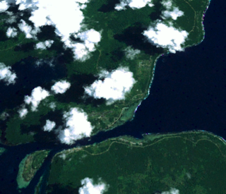
Bougainville Island is the main island of the Autonomous Region of Bougainville, which is part of Papua New Guinea. Its land area is 9,300 km2 (3,600 sq mi). The population of the whole province, including nearby islets such as the Carterets, is approximately 300,000. The highest point is Mount Balbi, on the main island, at 2,715 m (8,907 ft).
Bougainville Copper Limited (BCL) is a mining company of Papua New Guinea (PNG) that is listed on the Australian Securities Exchange (ASX). BCL operated the copper, gold and silver mine at the Panguna mine on Bougainville Island in PNG from 1971 to 15 May 1989, when mining operations were officially halted due to militant activity. The mine has remained closed since then.

Kieta is a port town located on the eastern coast of the island of Bougainville in Papua New Guinea, near the township of Arawa. After extensive destruction during the 1990 Civil Uprising on Bougainville, Kieta has few inhabitants now, and is known mainly for its transport connections.

UTC+11:00 is an identifier for a time offset from UTC of +11:00. This time is used in:

Empress Augusta Bay is a bay on the western side of the island of Bougainville Island, within the Autonomous Region of Bougainville in northeastern Papua New Guinea.
Uruava is an extinct Austronesian language formerly spoken in southeast Bougainville, Papua New Guinea.

The Torokina River is a river on Bougainville Island, within the Autonomous Region of Bougainville, in northeastern Papua New Guinea.
Jaba River is a river in Bougainville, Papua New Guinea. It empties to Empress Augusta Bay at 6.3833333°S 155.2166667°E. It was polluted by waste from the Panguna mine, which specialized in copper. The aquatic life of Jaba river was destroyed due to heavy metal pollution. The environmental pollution of river was one of the causes of armed conflict on the island and struggle of local people for independence.
Buka is a town located on the southern coast of Buka Island, in the Autonomous Region of Bougainville, in eastern Papua New Guinea. It is administered under Buka Rural LLG. It is the capital of the North Bougainville District and the interim capital of the Autonomous Region of Bougainville. It contains Our Lady of the Assumption Cathedral.
Torokina is a coastal village on Bougainville Island, in the Autonomous Region of Bougainville, eastern Papua New Guinea. It is administered under Torokina Rural LLG.
Arawa is the largest town and the former capital of the Autonomous Region of Bougainville in Papua New Guinea. It is administered under Arawa Rural LLG.
The Republic of the North Solomons was an unrecognised state that purported to exist for about six months in what is now the Autonomous Region of Bougainville, Papua New Guinea (PNG). It involved:
a 'Unilateral Declaration of Independence of the Republic of North Solomons' and a failed bid for self-determination at the UN

Buin is a town on Bougainville Island, and the capital of the South Bougainville District, in the Autonomous Region of Bougainville, in eastern Papua New Guinea. The island is in the northern Solomon Islands Archipelago of the Melanesia region, in the South Pacific Ocean.
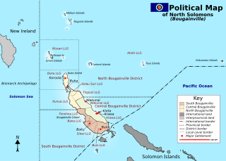
North Bougainville District is a district of the Autonomous Region of Bougainville of Papua New Guinea. Its capital is Buka on Buka Island. North Bougainville languages are spoken in the district.
South Bougainville District is a district of the Autonomous Region of Bougainville of Papua New Guinea. The district has four local-level governments. Its capital is Buin. South Bougainville languages are spoken in the district.
The 2017 Papua New Guinea earthquake was an 7.9 earthquake that struck at 04:30 UTC on 22 January 2017.
Arawa Rural LLG is a local-level government (LLG) of the Autonomous Region of Bougainville, Papua New Guinea.

The COVID-19 pandemic in the Autonomous Region of Bougainville is part of the ongoing worldwide pandemic of coronavirus disease 2019 caused by severe acute respiratory syndrome coronavirus 2. The Autonomous Region of Bougainville's confirmed its first case of the COVID-19 pandemic on Friday, August 7, 2020, in Arawa, Bougainville. The first documented arrival of COVID-19 in Bougainville occurred just before the start of the Bougainvillean general and presidential elections, which took place over the course of three weeks beginning on August 12, 2020, and ending on September 1, 2020.

