
Bougainville, officially the Autonomous Region of Bougainville, is an autonomous region in Papua New Guinea. The largest island is Bougainville Island, while the region also includes Buka Island and a number of outlying islands and atolls. The current capital is Buka, situated on Buka Island.

Bougainville Island is the main island of the Autonomous Region of Bougainville, which is part of Papua New Guinea. Its land area is 9,300 km2 (3,600 sq mi). The population of the whole province, including nearby islets such as the Carterets, is approximately 300,000. The highest point is Mount Balbi, on the main island, at 2,715 m (8,907 ft).

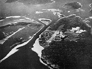
Kieta is a port town located on the eastern coast of the island of Bougainville in Papua New Guinea, near the township of Arawa. After extensive destruction during the 1990 Civil Uprising on Bougainville, Kieta has few inhabitants now, and is known mainly for its transport connections.

Buka Island is the second-largest island in the Autonomous Region of Bougainville, in eastern Papua New Guinea. It is in Buka Rural LLG of North Bougainville District, with the Autonomous Region's and district's capital city of Buka on the island.

Nissan Island is the largest of the Green Islands of Papua New Guinea. It is located at 4°30′S154°13′E, about 200 km east of Rabaul on New Britain and about 200 km north-west of Bougainville. The island is administered under Nissan Rural LLG in the Autonomous Region of Bougainville. Nissan island, along with other nearby islands, has been described as a "stepping stone island" and it is believed that this island plays an important role in helping various plant and animal species spread throughout the region.
Buka is a town located on the southern coast of Buka Island, in the Autonomous Region of Bougainville, in eastern Papua New Guinea. It is administered under Buka Rural LLG. It is the capital of the North Bougainville District and the interim capital of the Autonomous Region of Bougainville. It contains Our Lady of the Assumption Cathedral.
Arawa is the largest town and the former capital of the Autonomous Region of Bougainville in Papua New Guinea. It is administered under Arawa Rural LLG.

Nuguria or the Nuguria Islands, also known as the Abgarris or Fead Islands, are a Polynesian outlier and islands of Papua New Guinea. They are located nearly 150 km from the northern end of Buka island, in the Autonomous Region of Bougainville and consist of two closely spaced atoll formations.

The Solomon Islands (archipelago) is an island group in the western South Pacific Ocean, north-east of Australia. The archipelago is in the Melanesian subregion and bioregion of Oceania and forms the eastern boundary of the Solomon Sea. The many islands of the archipelago are distributed across the sovereign states of Papua New Guinea and Solomon Islands. The largest island in the archipelago is Bougainville Island, which is a part of the Autonomous Region of Bougainville along with Buka Island, the Nukumanu Islands, and a number of smaller nearby islands. Much of the remainder falls within the territory of Solomon Islands and include the atolls of Ontong Java, Sikaiana, the raised coral atolls of Bellona and Rennell, and the volcanic islands of Choiseul, Guadalcanal, Makira, Malaita, New Georgia, the Nggelas, Santa Isabel, and the Shortlands. The Santa Cruz Islands are not a part of the archipelago.

Buin is a town on Bougainville Island, and the capital of the South Bougainville District, in the Autonomous Region of Bougainville, in eastern Papua New Guinea. The island is in the northern Solomon Islands Archipelago of the Melanesia region, in the South Pacific Ocean.
The Bonis Peninsula is a narrow peninsula located on Bougainville Island, Papua New Guinea, at the north of the island. The Buka Passage separates the peninsula from Buka Island.
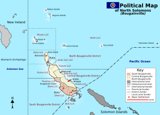
South Bougainville District is a district of the Autonomous Region of Bougainville of Papua New Guinea. The district has four local-level governments. Its capital is Buin. South Bougainville languages are spoken in the district.
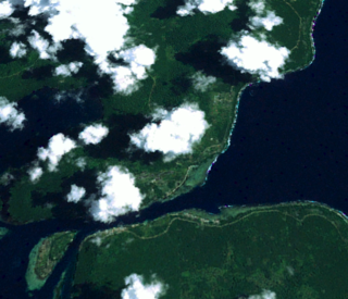
Buka Passage is a narrow strait that separates Buka Island from the northern part of Bougainville Island, within the Autonomous Region of Bougainville of northeastern Papua New Guinea.
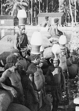
The upe is a traditional headdress worn by men in parts of Bougainville to symbolise their transition to adulthood. The term is also used to refer to the process of undergoing the transition and to the initiates themselves.
Selau is a district of the Autonomous Region of Bougainville, Papua New Guinea. Generally it is known as Selau-Suir Rural LLG which is one of the districts in Bougainville.
Joe Lera was a Papua New Guinean politician from 2012 to 2020. He was a United Resources Party member of the National Parliament of Papua New Guinea, representing the Bougainville Regional seat. Although regional members generally assume the position of Governor, due to the existence of the devolved Autonomous Bougainville Government Lera was referred to as the "Regional Member for Bougainville". He was Minister for Bougainville Affairs in the government of Peter O'Neill.
Buka Rural LLG is a local-level government (LLG) of comprising Buka Island in the Autonomous Region of Bougainville, Papua New Guinea. Several Northwest Solomonic languages are spoken in the LLG.

The COVID-19 pandemic in the Autonomous Region of Bougainville is part of the ongoing worldwide pandemic of coronavirus disease 2019 caused by severe acute respiratory syndrome coronavirus 2. The Autonomous Region of Bougainville's confirmed its first case of the COVID-19 pandemic on Friday, August 7, 2020, in Arawa, Bougainville. The first documented arrival of COVID-19 in Bougainville occurred just before the start of the Bougainvillean general and presidential elections, which took place over the course of three weeks beginning on August 12, 2020, and ending on September 1, 2020.
Moses Havini was a political activist from Buka Island in Papua New Guinea. He was a prominent campaigner for the independence of Bougainville from Papua New Guinea, beginning in the early 1970s. During the Bougainville Civil War he served as the official spokesman of the Bougainville Interim Government and Bougainville Revolutionary Army.

