Kilbirnie Homestead

Last updated

Kilbirnie Homestead
Kilbirnie Homestead (2009).jpg
Kilbirnie Homestead, 2009
Location Argoon-Kilburnie Road, Jambin, Shire of Banana, Queensland, Australia
Coordinates 24°14′48″S150°30′20″E / 24.2467°S 150.5056°E / -24.2467; 150.5056 Coordinates: 24°14′48″S150°30′20″E / 24.2467°S 150.5056°E / -24.2467; 150.5056
Design period 1870s - 1890s (late 19th century)
Built 1884
Official name: Kilbirnie Homestead
Type state heritage (landscape, built)
Designated 21 October 1992
Reference no. 600016
Significant period 1880s-1900s (historical)
1884-1900s (fabric)
Significant components headstone, kitchen/kitchen house, fencing, decorative finishes, residential accommodation - main house, burial/grave, shed/s, grave surrounds/railings
Australia Queensland location map.svg
Red pog.svg
Location of Kilbirnie Homestead in Queensland
Australia location map.svg
Red pog.svg
Kilbirnie Homestead (Australia)

Kilbirnie Homestead is a heritage-listed homestead at Argoon-Kilburnie Road, Jambin, Shire of Banana, Queensland, Australia. It was built in 1884. It was added to the Queensland Heritage Register on 21 October 1992. [1]

A homestead is a dwelling, especially a farmhouse, and adjacent outbuildings, typically on a large agricultural holding such as a ranch or station.

Jambin, Queensland Town in Queensland, Australia

Jambin is a rural town in the Shire of Banana, Central Queensland, Australia. The northern part of the town is in the locality of Smoky Creek and the southern part is in the locality of Argoon. In the 2011 census, Smoky Creek had a population of 308 people and Argoon had a population of 295.

Shire of Banana Local government area in Queensland, Australia

The Shire of Banana is a local government area located in the Capricorn region of Queensland, Australia, inland from the regional city of Gladstone. The shire was named after the first township in the region (Banana), which in turn was named for the burial site of a huge dun coloured bullock named 'Banana'. The council sits in the town of Biloela, which is the largest town in the Shire.

Contents

History

The buildings comprising Kilbirnie homestead are a series of vernacular timber structures erected by the Campbell family in the 19th and early 20th centuries. [1]

Ludwig Leichhardt explored the Callide and Dawson Valleys in 1844. Thomas Archer took up Eidsvold pastoral run and Charles Archer moved further north settling in the region of what is now Biloela. Other European pastoralists soon followed them in the 1850s, when this district was still a part of New South Wales (as the separation of Queensland did not occur until 1859). In 1869, the Department of Public Lands authorised the opening for selection of land from the runs of Winterbourne and Thalberg on the headwaters of Callide Creek. They were approximately 23 square miles each. A Promise of Lease for the two areas passed quickly through several hands, but in 1877 both runs were leased to Thomas Cadell. [1]

Ludwig Leichhardt German explorer of Australia

Friedrich Wilhelm Ludwig Leichhardt, known as Ludwig Leichhardt, was a German explorer and naturalist, most famous for his exploration of northern and central Australia.

Dawson River (Queensland) river in Queensland, Australia

The Dawson River is a river located in Central Queensland, Australia.

The Archer brothers were among the earliest European settlers in Queensland. They were explorers and pastoralists. Seven sons of William Archer, a Scottish timber merchant, they spent varying amounts of time in the colony of New South Wales, mainly in parts of what later became Queensland. A substantial number of locations in Queensland were either named by or for them. They were, in order of birth:

Settlement in the area prospered and the service town of Banana was established in the 1860s. In 1880 the Banana Divisional Board was formed. On 12 May 1883 John Campbell applied for a 10-year lease on an area of 12 square miles from the Thalberg run under the Settled Districts Pastoral Leases Act of 1876. Campbell had arrived in Brisbane in 1873 when he was 23 years old. Soon after his arrival, he married his fiancee, Elizabeth Brydges, who had accompanied him from Ireland. After working briefly on a sugar plantation on the Mary River, he obtained a position working as a shepherd and general hand for Robert Bell on Dumgree Station. While working at Dumgree, Campbell obtained sheep of his own and ran them on land rented from Bell. Capital from the sale of these sheep allowed the Campbells to set up their own property. [1]

Banana, Queensland Town in Queensland, Australia

Banana is a small town and rural locality in the Shire of Banana, Central Queensland, Australia. In the 2011 census, Banana had a population of 377 people.

Brisbane capital city of Queensland, Australia

Brisbane is the capital of and the most populated city in the Australian state of Queensland, and the third most populous city in Australia. Brisbane's metropolitan area has a population of 2.5 million, and the South East Queensland region, centred on Brisbane, encompasses a population of more than 3.5 million. The Brisbane central business district stands on the historic European settlement and is situated inside a peninsula of the Brisbane River, about 15 kilometres from its mouth at Moreton Bay. The metropolitan area extends in all directions along the floodplain of the Brisbane River Valley between Moreton Bay and the Great Dividing Range, sprawling across several of Australia's most populous local government areas (LGAs)—most centrally the City of Brisbane, which is by far the most populous LGA in the nation. The demonym of Brisbane is "Brisbanite".

Mary River (Queensland) river system in Queensland, Australia

The Mary River is a major river system located in the South East and Wide Bay–Burnett regions of Queensland, Australia.

In 1884 Campbell was granted a 10-year lease for his selected land, which he called Kilburnie. After having prepared the materials needed, he began to construct a six roomed house, stockyard and fences on the land, with help from a bush carpenter named Bryce Kilpatrick. In 1885, when the house was completed, he was able to move his wife and children from Dumgree to their new home. The following year, 6 square miles, being about half of the Kilbirnie run was resumed. Campbell protested this on the grounds that it was unwatered and therefore unsuitable for selection. He was allowed to exercise his right of grazing on the land and in 1889 was offered an Occupation License for the resumed portion and subsequently held occupation licenses for the whole. [1]

Campbell raised cattle and Clydesdale horses at Kilbirnie and by 1892 had constructed stables and other outbuildings and had a horse paddock and a paddock under cultivation. He had also erected about 4 miles (6.4 km) of fencing. The first house had been built directly on the ground and suffered extensive white ant damage, so that it was moved and rebuilt in 1901. It was possibly at this time that the rear of the building was clad in weatherboards. In 1902 a license to erect a hayshed and stockyard and to make a dam was granted. In 1903 a license to erect a house of 12 rooms was approved, the former house being now used as a kitchen wing. [1]

Clydesdale horse horse breed

The Clydesdale is a breed of draft horse named for and derived from the farm horses of Clydesdale, a county in Scotland. Although originally one of the smaller breeds of draught horses, it is now a tall breed. Often bay in color, they show significant white markings due to the presence of sabino genetics. The breed was originally used for agriculture and haulage, and is still used for draught purposes today. The Budweiser Clydesdales are some of the most famous Clydesdales, and other members of the breed are used as drum horses by the British Household Cavalry. They have also been used to create and improve other breeds.

At this time, Kilbirnie was also a coach stop. Until Biloela was founded in 1924, Banana was the main town in the district. From 1897, mail had been delivered to the area by G H (Bob) Fry. By the early 1900s, demand was sufficient for him to operate a 3-seater wagonette, known locally as Fry's mail coach, over the route between Gladstone and Banana. This took two days and the coach stopped at Kilbirnie for morning tea and a change of horses. This service continued until made redundant in 1928. [1]

In 1921 an anomaly was discovered between the land described officially as Kilbirnie and the land actually worked by Campbell. This was resolved in favour of the land in use. In 1924, 9,267 acres (3,750 ha) were resumed in connection with the Burnett Settlement Scheme. At the time the property had grown to 48 square miles by the addition of land held by occupation lease. [1]

Elizabeth Campbell died in 1913 after having had eight children. John Campbell died in 1943 at the age of 98. The house continued in the ownership of family members, although it was unoccupied for some 20 years from the 1970s and an overseer was employed to care for the property. A new generation of family members, great grandchildren of John and Elizabeth Campbell, were later living in the house. [1]

Description

Kilbirnie homestead is close to the Boundary Hill Mine Road and consists of a complex of timber residential and working buildings including a house, detached kitchen and several sheds. The site also has two graves. [1]

The main dwelling is a timber house raised on high timber stumps, which has had rooms built underneath. It has a hipped roof clad in corrugated iron. There is an encircling verandah to the upper level with a separate roof supported on timber posts. Subsidiary L-shaped bedrooms are built into each corner of the verandah so that there is an open section in the centre of each elevation. The handrail across these verandah sections is timber, with steel mesh filling the area below. This upper floor contains a living room, main bedroom and two smaller bedrooms in the core section. Original decorative colour schemes survive and include stencilled stylised iris on the upper walls of the living room and a stencilled dado in the bedroom to the north. [1]

On the ground floor the central section between the stumps is built in with vertical corrugated iron sheeting, creating four rooms including a dining room and storerooms. The area surrounding this core is concreted and serves as a verandah. There is a detached bathroom beside the house at the northwest corner. This is constructed of ripple iron with a curved corrugated iron roof. [1]

To the rear of the house, and connected with it by a covered walkway, is a single storey slab and weatherboard building set on low timber stumps. It has a gabled roof clad in corrugated iron. A verandah runs between two projecting rooms along the long axis of the building facing the house. The rear of the building and the rear portion of the southern end have been clad in weatherboard. This building serves as a detached kitchen building, though it contains other rooms. The kitchen has been extended at the northern end and also into the verandah room on the northeast corner. Internal walls of corrugated iron divide the rest of the building into a store and large nursery room. This room has a series of polychrome stencils of "Japanese" figures and birds applied as a frieze. [1]

The residential buildings are separated from the working buildings by a timber picket fence. There are three sheds surrounding a yard area to the rear of the kitchen building. [1]

The shed on the southern side of the yard has a pole frame and a hipped roof clad in corrugated iron. Two walls are of drop log construction and the building is open on two sides. [1]

The shed to the west of the yard is a rectangular building with a gabled roof and shallow side aisles, the southern side of which is open, the roof being supported by timber posts. The roof is clad in corrugated iron, as is the western wall. It has a pole frame and has walls variously of timber and corrugated iron. [1]

The building to the north of the yard has a gabled roof clad with corrugated iron and has a skillion roofed extension on its northern side. The main part of the building is constructed of dropped slabs with vertical slabs to the extension. The wall on the southern side has gates into the yard and this building may have housed animals. [1]

To the north of the complex are the burials of Elizabeth Campbell, who died in 1913, and of John Campbell, who died in 1943. The graves have matching headstones and are enclosed by decorative iron railing protected by a modern steel pipe enclosure. [1]

Heritage listing

Kilbirnie Homestead was listed on the Queensland Heritage Register on 21 October 1992 having satisfied the following criteria. [1]

The place is important in demonstrating the evolution or pattern of Queensland's history.

Kilbirnie homestead illustrates the pattern of early European exploration and settlement of Queensland where the development of pastoral properties preceded agriculture and the establishment of towns. As an early homestead in the Leichhardt Pastoral District, which has remained in use, it has associations with the development of the pastoral industry in Queensland. [1]

The place is important in demonstrating the principal characteristics of a particular class of cultural places.

Kilbirnie homestead complex provides a record of an evolving pastoral property from the slab buildings of first settlement in the 1880s to a comfortable house of sawn timber. It demonstrates the principal characteristics of such a homestead group well, comprising a main house with detached kitchen, associated outbuildings, graves and fences and illustrates the building techniques traditionally used for these. [1]

The place has a special association with the life or work of a particular person, group or organisation of importance in Queensland's history.

Kilbirnie homestead has a special association with the life and work of four generations of the Campbell family who, as early pastoralists, contributed to the development of the area. [1]

Related Research Articles

Canning Downs

Canning Downs was the first residential establishment built by a white person on the Darling Downs in Queensland, Australia. It is located a short drive from the town of Warwick and originally extended south east to Killarney and the McPherson Range. The area was first named after the British statesman George Canning by Allan Cunningham.

Bellevue Homestead

Bellevue Homestead is a heritage-listed homestead currently located in Coominya, Somerset Region, Queensland, Australia. It was built from c. 1872 to c. 1910. It was added to the Queensland Heritage Register on 21 October 1992.

Jondaryan Homestead

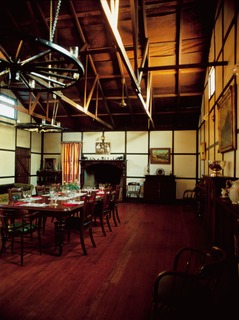
Jondaryan Homestead is a heritage-listed homestead at Evanslea Road, Jondaryan, Toowoomba Region, Queensland, Australia. It was the base of the former Jondaryan pastoral station, which was originally taken up in 1840, and at one time was the largest freehold station in Queensland. The site contains the current house, which was built after the original was destroyed by fire in 1937, the original kitchen dating from 1844, and a kitchen, butcher's shop, shearer's quarters, stables, dairy, toilet block and store, many dating from the 1860s. It also contains the remains of horse stalls, a slaughterhouse, hide store, and Chinese gardener's glasshouse. It was added to the Queensland Heritage Register on 21 October 1992.

Westbrook Homestead

Westbrook Homestead is a heritage-listed homestead at Coupers Road, Westbrook, Toowoomba Region, Queensland, Australia. It was built from 1864 to 1867. It was added to the Queensland Heritage Register on 21 October 1992.

Nindooinbah Homestead

Nindooinbah Homestead is a heritage-listed homestead at Nindooinbah Connection Road, Nindooinbah, Scenic Rim Region, Queensland, Australia. It was built from c. 1858 to 1907. It is also known as Nindooinbah House. It was added to the Queensland Heritage Register on 21 October 1992.

Schmidt Farmhouse

Schmidt Farmhouse & Outbuildings is a heritage-listed homestead at 3 Worongary Road, Worongary, City of Gold Coast, Queensland, Australia. It was built from 1880s to c. 1910. It was added to the Queensland Heritage Register on 8 April 1997.

Ballandean Homestead

Ballandean Homestead is a heritage-listed homestead at Ballandean, Southern Downs Region, Queensland, Australia. It was built from c. 1840 to 1890s circa. It was added to the Queensland Heritage Register on 21 October 1992.

Booubyjan Homestead

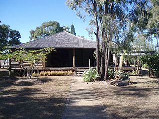
Booubyjan Homestead is a heritage-listed homestead at Booubyjan Road, Booubyjan, Gympie Region, Queensland, Australia. It was built from the 1860s to the 1870s circa. It was added to the Queensland Heritage Register on 21 October 1992.

Wodonga House

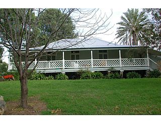
Wodonga House is a heritage-listed farmhouse at Woolooga Road, Widgee, Gympie Region, Queensland, Australia. It was built in 1902. It was added to the Queensland Heritage Register on 21 October 1992.

Glengarry Homestead

Glengarry Homestead is a heritage-listed homestead at Gladstone-Monto Road, Boynedale, Gladstone Region, Queensland, Australia. It was built from c. 1894 to c. 1920. It was added to the Queensland Heritage Register on 21 October 1992.

Raglan Homestead

Raglan Homestead is a heritage-listed homestead at Raglan Station Road, Raglan, Gladstone Region, Queensland, Australia. It was built from c. 1857 to 1913. It is also known as Raglan Station. It was added to the Queensland Heritage Register on 21 October 1992.

Gracemere Homestead

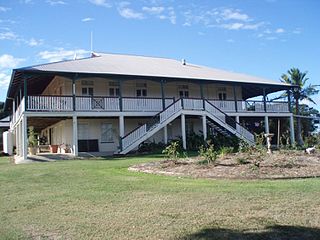
Gracemere Homestead is a heritage-listed homestead at 234 Gracemere Road, Gracemere, Rockhampton Region, Queensland, Australia. It was built from 1858 to 1890s. It was added to the Queensland Heritage Register on 21 October 1992.

Strathmore Homestead

Strathmore Homestead is a heritage-listed homestead at Strathmore Station on Strathmore Road, Springlands, Whitsunday Region, Queensland, Australia. It was built from the 1860s onward. It is also known as Strathmore Station. It was added to the Queensland Heritage Register on 13 November 2008.

Gunnawarra Homestead

Gunnawarra Homestead is a heritage-listed homestead at Gunnawarra Road, Gunnawarra, Tablelands Region, Queensland, Australia. It was built from 1878 to 1908. It was added to the Queensland Heritage Register on 21 October 1992.

Burrandowan Station Homestead homestead at Kingaroy Road, Durong, South Burnett Region, Queensland, Australia

Burrandowan Station Homestead is a heritage-listed homestead at Kingaroy Road, Durong, South Burnett Region, Queensland, Australia. It was built from 1848 to c. 1927. It was added to the Queensland Heritage Register on 21 October 1992.

Eidsvold Homestead

Eidsvold Homestead is a heritage-listed homestead at Eidsvold Road, Eidsvold, North Burnett Region, Queensland, Australia. It was built in 1850. It was added to the Queensland Heritage Register on 21 October 1992.

Greycliffe Homestead heritage-listed homestead in Queensland, Australia, built from 1863

Greycliffe Homestead is a heritage-listed homestead at 48 Gladstone Road, Biloela, Shire of Banana, Queensland, Australia. It was built from c. 1863 onwards. It was added to the Queensland Heritage Register on 21 October 1992.

Tarong Homestead

Tarong Homestead is a heritage-listed homestead at Cooyar Road, Tarong, South Burnett Region, Queensland, Australia. It was built from 1840s circa to 1890s circa. It was added to the Queensland Heritage Register on 21 October 1992.

Boondooma Homestead homestead at Mundubbera - Durong Road, Boondooma, South Burnett Region, Queensland

Boondooma Homestead is a heritage-listed homestead at Mundubbera - Durong Road, Boondooma, South Burnett Region, Queensland, Australia. It was built from the 1850s to the 1870s. It was added to the Queensland Heritage Register on 21 October 1992.

Avoca Homestead Complex human settlement in Australia

The Avoca Homestead Complex is a heritage-listed former station homestead and station facilities and now catered accommodation and visitor attraction at 1122a Low Darling Road, Wentworth, in the Wentworth Shire, New South Wales, Australia. It was built between 1871 and 1879. It is also known as the Avoca Station Homestead and outbuildings. It was added to the New South Wales State Heritage Register on 8 April 2016.

References

  1. 1 2 3 4 5 6 7 8 9 10 11 12 13 14 15 16 17 18 19 20 21 22 "Kilbirnie Homestead (entry 600016)". Queensland Heritage Register . Queensland Heritage Council. Retrieved 1 August 2014.

Attribution

CC-BY-icon-80x15.png This Wikipedia article was originally based on "The Queensland heritage register" published by the State of Queensland under CC-BY 3.0 AU licence (accessed on 7 July 2014, archived on 8 October 2014). The geo-coordinates were originally computed from the "Queensland heritage register boundaries" published by the State of Queensland under CC-BY 3.0 AU licence (accessed on 5 September 2014, archived on 15 October 2014).

Commons-logo.svg Media related to Kilbirnie Homestead at Wikimedia Commons