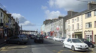
Gort is a town of around 2,800 inhabitants in County Galway in the west of Ireland. Located near the border with County Clare, the town lies between the Burren and the Slieve Aughty and is served by the R458 and R460 regional roads, which connect to the M18 motorway.

Cratloe is a village in County Clare, Ireland, situated between Limerick and Shannon in the mid-west of Ireland. It is possible that the name derives from Croit-shliabh meaning "hump-backed hill", referring to Woodcock Hill. The present-day parish of Cratloe consists of the former parish of Kilfintinan and a portion of the contemporary parish of Killeely. This was agreed upon by priests in the 18th century, who claimed there were not enough members of the clergy to operate fully in both parishes.

Kilmallock is a town in south County Limerick, Ireland, near the border with County Cork, 30 km south of Limerick city. There is a Dominican Priory in the town and King's Castle. The remains of medieval walls which encircled the settlement are still visible.

Newcastle West or simply Newcastle is a town in west County Limerick, Ireland. It is the largest town in the county, excluding Limerick city. It is also the county town, and sits on the River Arra which flows into the River Deel. Newcastle West is in the middle of a great bowl-shaped valley in West Limerick, known one time as the valley of the Wild Boar, apparently due to the abundance of this animal here when the area was thickly wooded. The crest of the town carries the image of a wild boar. The town is partly in the civil parish of Newcastle.

Killaloe is a small town in east County Clare, Ireland. It lies on the River Shannon on the western bank of Lough Derg and is connected by Killaloe Bridge to the "twin town" of Ballina on the eastern bank of the lake.

Athea is a village in west County Limerick, Ireland. Athea has a Roman Catholic church, and is the centre for the parish of Athea, which encompasses several nearby townlands.

Croom is a village in County Limerick, Ireland. It is located just off the N20 on the River Maigue. It is 8 km southeast of Adare on the N20. The village is in a townland and civil parish of the same name.

Galbally is a village in southeast County Limerick, Ireland, on the border with County Tipperary. It is located at the foot of the Galtee Mountains and at the western approach to the Glen of Aherlow. The Aherlow River, flowing down from the Galtee mountains, runs by the village, to meet the Suir at Kilmoyler a short distance north of Cahir. Galbally is in a valley overlooked by the Galtee Mountains. The village is in a townland and civil parish of the same name.

Kilcoole is a town in County Wicklow, Ireland. It is 3 kilometres (2 mi) south of Greystones, 14 kilometres (9 mi) north of Wicklow, and about 28 kilometres (20 mi) south of Dublin. It was used as a filming location for the Irish television series Glenroe, which ran through the 1980s and 1990s.

Dromcollogher, officially Dromcolliher, is a village located at the crossroads of the R522 and R515 regional roads in the west of County Limerick, Ireland. It is part of the parish of Dromcollogher-Broadford. It is also very close to the northern boundary of County Cork.

Ballingarry is a village in County Limerick, Ireland. It is located near the village of Granagh and between the towns of Rathkeale and Kilmallock on the R518 road. Ballingarry lies in a civil parish of the same name, and within the ecclesiastical parish of Ballingarry-Granagh in the Roman Catholic Diocese of Limerick. The village had a population of 570 as of the 2022 census, up from 521 at the 2016 census.

Kilcummin is a beachhead and civil parish on the northern coast of County Mayo in Ireland. Traditionally a fishing community, the Kilcummin area is sparsely populated. The "Tír Sáile - North Mayo Sculpture Trail" and "Tour d'Humbert" tourist route lead through the area. Kilcummin overlooks Killala Bay, the blue flag beach "An Trá nRoss", "Bartra Island" and lies on the opposite shore to Enniscrone and its beach in County Sligo.

Kilsheelan is a village and civil parish within the barony of Iffa and Offa East in County Tipperary, Ireland. A part of the civil parish is in neighbouring County Waterford. It is also one half of the Roman Catholic parish of Kilsheelan & Kilcash in the Roman Catholic Diocese of Waterford and Lismore.

Kilnaboy or Killinaboy is a village, townland and civil parish in County Clare, Ireland. It is located in the Burren, and as of the 2011 census the area had 347 inhabitants.
Broadford is a village in the west of County Limerick in Ireland. It is part of the Roman Catholic parish of Dromcollogher-Broadford. In the 2016 census, the resident population of Broadford village was 276, and the population of the Broadford electoral division was 960.
Dromcolliher-Broadford is a parish bordering north Cork in County Limerick, Ireland. There are two villages within the parish, Dromcolliher and Broadford.

Kilmaley is a village in County Clare, Ireland, 8 kilometres (5 mi) west of Ennis. The name "Kilmaley" came from the Irish language "Cill Mhaile" which translates to Church of (Saint) Maley.

Fanning's Castle, also called Whitamore's Castle, is the remains of a tower house and National Monument located in Limerick, Ireland.

Killursa is a medieval church and national monument in County Galway, Ireland. The church is located on the outskirts of Westport, about east-northeast of the town of Galway. It has a rectangular mass in the Early Christian or Romanesque style, with an octagonal tower at its northeast corner. The tower was apparently added in the 15th century. The church is datable from the 12th century, and may have been founded by St. Columba. The current structure is from the 16th century.


