Killik River

Last updated
Killik River
Relief map of USA Alaska.png
Red pog.svg
Location of the mouth of the Killik River in Alaska
Location
Country United States
State Alaska
Borough North Slope, Yukon–Koyukuk Census Area
Physical characteristics
SourceConfluence of April and Kakivilak creeks
 - location Gates of the Arctic National Park, Brooks Range, Yukon–Koyukuk Census Area
 - coordinates 67°46′09″N154°32′54″W / 67.76917°N 154.54833°W / 67.76917; -154.54833 [1]
 - elevation4,863 ft (1,482 m) [2]
River mouth Colville River
 - location52 miles (84 km) southwest of Umiat, North Slope Borough
 - coordinates 69°00′26″N153°54′35″W / 69.00722°N 153.90972°W / 69.00722; -153.90972 Coordinates: 69°00′26″N153°54′35″W / 69.00722°N 153.90972°W / 69.00722; -153.90972 [1]
 - elevation548 ft (167 m) [1]
Length105 mi (169 km) [1]

The Killik River[ pronunciation? ] is a 105-mile (169 km) tributary of the Colville River in the U.S. state of Alaska. [1] It begins in the northern portion of Gates of the Arctic National Park and flows north onto property of the Arctic Slope Regional Corporation. [3]

Colville River (Alaska) river in Alaska

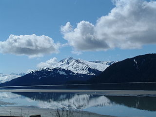
The Colville River is a major river of the Arctic Ocean coast of Alaska in the United States, approximately 350 miles (560 km) long. One of the northernmost major rivers in North America, it drains a remote area of tundra on the north side of the Brooks Range entirely above the Arctic Circle. The river is frozen for more than half the year and floods each spring.

U.S. state constituent political entity of the United States

In the United States, a state is a constituent political entity, of which there are currently 50. Bound together in a political union, each state holds governmental jurisdiction over a separate and defined geographic territory and shares its sovereignty with the federal government. Due to this shared sovereignty, Americans are citizens both of the federal republic and of the state in which they reside. State citizenship and residency are flexible, and no government approval is required to move between states, except for persons restricted by certain types of court orders. Four states use the term commonwealth rather than state in their full official names.

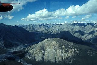
The river's headwaters are near Survey Pass in the Endicott Mountains on the north slope of the central Brooks Range, and the river mouth is south of Angoyakvik Pass. [4] The direction of the headwaters stream is northwest at first, then sharply northeast before April and Easter creeks enter from the right slightly north of the North Slope Borough boundary. [4] The river continues northeast for much of its course until it turns northwest again on the lower reaches after receiving the Okokmilaga River from the right. [4]

Endicott Mountains mountain range

The Endicott Mountains are a range of mountains, part of the Brooks Range in northern Alaska. They are located in the middle of the Brooks range and run some 151 miles (243 km) east–west. To the east are the Philip Smith Mountains and to the west are the Schwatka Mountains. The Endicott Mountains are separated from the Philip Smith Mountains by the Middle Fork of the Koyukuk River, the Dalton Highway, and Atigun Pass. The Endicott Mountains are separated from the Schwatka Mountains by Walker Lake, the upper reaches of the West Fork of the Kobuk River, Akabluak Pass, and the Noatak River. The Endicott Mountains are separated from the mountains north of the Schwatka by Lucky Six Creek, Gull Pass, Gull Creek, a portion of the Alatna River and the Killik River.

Brooks Range mountain range in Alaska, United States

The Brooks Range is a mountain range in far northern North America stretching some 700 miles (1,100 km) from west to east across northern Alaska into Canada's Yukon Territory. Reaching a peak elevation of 8,976 feet (2,736 m) on Mount Isto, the range is believed to be approximately 126 million years old.

River mouth end of a river

A river mouth is the part of a river where the river debouches into another river, a lake, a reservoir, a sea, or an ocean.

Major tributaries of the Killik are April and Easter creeks, as well as the Okokmilaga. [4] North of Easter Creek, tributary streams, such as Aniakvik Creek and Nigaktukvik Creek, flow predominantly through short, narrow, V-shaped valleys.

The main stem flows down a U-shaped glacial valley containing lakes, sand dunes, lateral moraines, and alpine tundra. [5] This valley, about 2 miles (3 km) wide initially, widens to between 3 and 5 miles (5 and 8 km) on the lower reaches, and the river becomes braided. [5] Copious stretches of dwarf birch (betula nana), and sedges, with large expanses of sedge bogs and tussocks dominate the tundra.

Main stem final large channel of a riverine system

In hydrology, a main stem is "the primary downstream segment of a river, as contrasted to its tributaries". Water enters the main stem from the river's drainage basin, the land area through which the main stem and its tributaries flow. A drainage basin may also be referred to as a watershed or catchment.

Tundra biome where the tree growth is hindered by low temperatures and short growing seasons

In physical geography, tundra is a type of biome where the tree growth is hindered by low temperatures and short growing seasons. The term tundra comes through Russian тундра from the Kildin Sami word тӯндар meaning "uplands", "treeless mountain tract". Tundra vegetation is composed of dwarf shrubs, sedges and grasses, mosses, and lichens. Scattered trees grow in some tundra regions. The ecotone between the tundra and the forest is known as the tree line or timberline.

Braided river A network of river channels separated by small, and often temporary, islands called [[braid bar]]s

A braided river, or braided channel, consists of a network of river channels separated by small, often temporary, islands called braid bars or, in British usage, aits or eyots. Braided streams occur in rivers with low speed, low slope, and/or large sediment load. Braided channels are also typical of environments that dramatically decrease channel depth, and consequently channel velocity, such as river deltas, alluvial fans, and peneplains.

The Killik is fed largely by precipitation and snow melt, and hence its waters are relatively clear of the sediment that characterizes glacial streams.

See also

Related Research Articles

Kobuk River watercourse in the United States of America

The Kobuk River is a river located in the Arctic region of northwestern Alaska in the United States. It is approximately 280 miles (451 km) long. Draining a basin with an area of 12,300 square miles (32,000 km2), the Kobuk River is among the largest rivers in northwest Alaska with widths of up to 1500 feet and flow at a speed of 3–5 miles per hour in its lower and middle reaches. The average elevation for the Kobuk River Basin is 1,300 feet (400 m) above sea level, ranging from near sea level to 11,400 feet. Topography includes low, rolling mountains, plains and lowlands, moderately high rugged mountainous land, and some gently sloped plateaus and highlands. The river contains an exceptional population of sheefish, a large predatory whitefish within the salmon family, found throughout the Arctic that spawns in the river's upper reaches during the autumn. A portion of the vast Western Arctic Caribou Herd utilize the Kobuk river valley as winter range.

Turnagain Arm

Turnagain Arm is a waterway into the northwestern part of the Gulf of Alaska. It is one of two narrow branches at the north end of Cook Inlet, the other being Knik Arm. Turnagain is subject to climate extremes and large tide ranges.

Beaver Creek (Yukon River tributary) clear water river in Alaska

Beaver Creek is a 180-mile (290 km) tributary of the Yukon River in the U.S. state of Alaska. The creek begins at the confluence of Champion and Bear creeks in the White Mountains National Recreation Area, about 50 miles (80 km) north of Fairbanks. From there it flows west around the southern end of the White Mountains, then northeast into the Yukon Flats National Wildlife Refuge, then west into the Yukon River downstream of Beaver.

Chandalar River river in the United States of America

The Chandalar River is a 100-mile (160 km) tributary of the Yukon River in the U.S. state of Alaska. Its peak flow, recorded by the United States Geological Survey (USGS) between 1964 and 1974 at a stream gauge at Venetie, was 62,800 cubic feet per second (1,780 m3/s) on June 9, 1968.

Ivishak River river in the United States of America

The Ivishak River is a 95-mile (153 km) tributary of the Sagavanirktok River in the North Slope Borough of the U.S. state of Alaska. Fed by glaciers at the headwaters, the Ivishak flows northeast, then northwest, through the Philip Smith Mountains and the northern foothills of the Arctic National Wildlife Refuge. It enters the Sagavanirktok River on the coastal plain south of Prudhoe Bay.

Selawik National Wildlife Refuge

Selawik National Wildlife Refuge in northwest Alaska in the Waring Mountains was officially established in 1980 with the passage of the Alaska National Interest Lands Conservation Act (ANILCA).

Blackfoot River (Idaho) river in the United States of America

The Blackfoot River is a tributary of the Snake River in the U.S. state of Idaho. Formed by the confluence of Diamond Creek and Lanes Creek, it flows 135 miles (217 km) to its mouth at the Snake River. The river is part of the Columbia River Basin.

Cispus River river in the United States of America

The Cispus River is about 54 miles (87 km) long and flows into the Cowlitz River at Lake Scanewa in the Cascade Range of Washington. Its tributaries drain most of south-central and southeastern Lewis County, extreme northeast Skamania County, and some of western Yakima County.

Kiwalik River river in the United States of America

The Kiwalik River is a stream on the Seward Peninsula in the U.S. state of Alaska. The headwaters of the river originate in the eastern portion of the peninsula, around Granite Mountain. The river flows north to its mouth at Kiwalik Lagoon, Chukchi Sea. The start of the 20th century mining town of Candle is found on its western bank at the confluence of Candle Creek. The ore minerals and materials found in the river basin are galena, gold, pyrite, scheelite, silver and sphalerite, and the primary commodities are tungsten, lead and zinc.

Nesquehoning Creek river in the United States of America

Nesquehoning Creek is an east flowing 14.9-mile-long (24.0 km) tributary of the Lehigh River in northeastern Pennsylvania in the United States.

Etivluk River river in the United States of America

The Etivluk River is a 56-mile (90 km) tributary of the Colville River in the U.S. state of Alaska. A bend in the river about 15 miles (24 km) from the mouth has been identified as one of the most remote locations in mainland Alaska. It is about 120 miles (190 km) from the nearest towns of Ambler to the southwest and Atqasuk to the north and farther from any other settled area in the state.

Northwest Branch Anacostia River tributary of the Anacostia River River, in Montgomery and Prince George’s counties, Maryland, United States

Northwest Branch Anacostia River is a 21.5-mile-long (34.6 km) free-flowing stream in Montgomery County and Prince George's County, Maryland. It is a tributary of the Anacostia River, which flows to the Potomac River and the Chesapeake Bay.

Herron River river in the United States of America

The Herron River is a 48-mile (77 km) tributary of the Foraker River in central Alaska in the United States. It drains an area on the north slope of the Alaska Range on the south edge of the Tanana Valley southwest of Fairbanks.

Foraker River river in the United States of America

The Foraker River is a 60-mile (97 km) stream in central Alaska in the United States. It drains an area on the north slope of the Alaska Range on the south edge of the Tanana Valley southwest of Fairbanks. The Herron River is a major tributary.

Lakina River river in the United States of America

Lakina River is a tributary of the Chitina River in the U.S. state of Alaska. It is located in the Wrangell–St. Elias National Park and Preserve.

Elk Run (West Branch Fishing Creek tributary) tributary of West Branch Fishing Creek in Sullivan and Columbia Counties, Pennsylvania

Elk Run is tributary of West Branch Fishing Creek in Sullivan County and Columbia County, in Pennsylvania, in the United States. It is approximately 4.8 miles (7.7 km) long and flows through Davidson Township in Sullivan County and Sugarloaf Township in Columbia County. The watershed of the stream has an area of 7.49 square miles (19.4 km2). The stream has three named tributaries: Gallows Run, Hog Run, and Long Run. Elk Run is considered to be an Exceptional Value stream and a Migratory Fishery. The forests surrounding it are deemed by the Sullivan County Natural Areas Inventory to be a "locally significant" area. The stream is named for an elk that was killed in it in the 1840s.

Sorber Run river in the United States of America

Sorber Run is a tributary of Bowman Creek in Luzerne County and Wyoming County, in Pennsylvania, in the United States. It is approximately 3.1 miles (5.0 km) long and flows through Lake Township in Luzerne County and Noxen Township in Wyoming County. The watershed of the stream has an area of 2.08 square miles (5.4 km2). The surficial geology in the stream's vicinity consists of alluvium and Wisconsinan Till. The watershed is designated as Exceptional Value waters and a Migratory Fishery. The stream is one of two Wilderness Trout Streams in Wyoming County.

Broad Hollow Run is a tributary of Bowman Creek in Wyoming County, Pennsylvania, in the United States. It is approximately 1.0 mile (1.6 km) long and flows through Noxen Township. The watershed of the stream has an area of 1.04 square miles (2.7 km2). The surficial geology in the vicinity of the stream consists of alluvium, alluvial fan, and Wisconsinan Till. Its watershed is designated as a High-Quality Coldwater Fishery and a Migratory Fishery.

Butternut Run is a tributary of Bowman Creek in Luzerne County, Pennsylvania, in the United States. It is approximately 1.5 miles (2.4 km) long and flows through Lake Township. The watershed of the stream has an area of 1.30 square miles (3.4 km2). The surficial geology along the stream consists of Wisconsinan Till. Its drainage basin is designated as a High-Quality Coldwater Fishery and a Migratory Fishery and the stream is Class A Wild Trout Waters.

Ipnavik River river in Alaska, United States

The Ipnavik River is a 68-mile-long (109 km) tributary of the Colville River in the Alaska North Slope which was part of the traditional lands of the Iñupiat, who named it "Ipnavak" which means "place where young Dall sheep grow up" with its headwaters in the Brooks Range. The Ipnavik River flows northeast to meet the Colville River 50 miles (80 km). It flows north northeast of Howard Pass, which is the mouth of the Ipnavik. The name was documented by the United States Geological Survey in 1925.

References

  1. 1 2 3 4 5 "Killik River". Geographic Names Information System. United States Geological Survey. January 1, 2000. Retrieved September 5, 2013.
  2. Source elevation derived from Google Earth search using GNIS source coordinates.
  3. "Lands". Arctic Slope Regional Corporation. 2013. Retrieved September 5, 2013. A clickable Portable Document Format (PDF) map filed under "Land Access" shows the private lands along the Killik River.
  4. 1 2 3 4 Alaska Atlas & Gazetteer (7th ed.). Yarmouth, Maine: DeLorme. 2010. p. 136. ISBN   978-0-89933-289-5.
  5. 1 2 "Killik River: Barrow Alaska Whitewater Kayaking Routes". Trails.com. Retrieved September 5, 2013.