Kilroot (District Electoral Area)

Last updated

Kilroot was one of the three district electoral areas in Carrickfergus, Northern Ireland which existed from 1985 to 2014. The district elected five members to Carrickfergus Borough Council from 1985 to 1993, and six members from 1993 to 2014, and formed part of the East Antrim constituencies for the Northern Ireland Assembly and UK Parliament.

Contents

It was created for the 1985 local elections, replacing Carrickfergus Area B which had existed since 1973, and contained the wards of Blackhead, Boneybefore, Eden, Victoria and Whitehead. For the 1993 local elections, it gained a sixth ward, Bluefield. It was abolished for the 2014 local elections and most of the area was transferred to the Carrick Castle DEA, with Whitehead moving to the Larne Lough DEA.

Councillors

ElectionCouncillor
(Party)
Councillor
(Party)
Councillor
(Party)
Councillor
(Party)
Councillor
(Party)
Councillor
(Party)
2011 Isobel Day
(Alliance)
Eric Ferguson
(UUP)
Lynn McClurg
(DUP)
Terence Clements
(DUP)
Billy Ashe
(DUP)
James Brown
(UUP)/
(Independent Unionist)
2005
2001 Brenda Crampsey
(Alliance)
Robin Cavan
(Alliance)
1997 Samuel Crowe
(Conservative)/
(Independent Unionist)
1993 Alexander Beggs
(UUP)
William Donaldson
(Alliance)
Robert Patton
(UUP)/
(Independent Unionist)
1989 William Cross
(DUP)
5 seats
1985–1993
1985 Wesley Mitchell
(UUP)

2011 Election

2005: 3 x DUP, 1 x Alliance, 1 x UUP, 1 x Independent

2011: 3 x DUP, 1 x Alliance, 1 x UUP, 1 x Independent

2005-2011 Change: No change

Kilroot - 6 seats [1]
PartyCandidateFPv%Count
123456
Independent James Brown*22.17%1,179     
DUP Billy Ashe*22.06%1,173     
DUP Terence Clements*9.68%515631.4 909.32   
Alliance Isobel Day*12.99%691753.8 762.08   
DUP Lynn McClurg*7.35%391456.2 545.84 558.6 688.94 744.77
Ulster Unionist Eric Ferguson*6.75%359428.6 443.36 455.64 464.57 726.59
Alliance Robert Logan9.27%493521.8 525.04 626.04 628.13 672.21
Ulster Unionist Cathy Vizard6.54%348402.4 413.92 425.56 426.51  
Green (NI) Mark Bailey3.18%169186.2 191.96    
Electorate: 11,430  Valid: 5,318 (46.53%)  Spoilt: 78  Quota: 760  Turnout: 5,396 (47.21%)  

    2005 Election

    2001: 2 x DUP, 2 x Alliance, 1 x UUP, 1 x Independent

    2005: 3 x DUP, 1 x Alliance, 1 x UUP, 1 x Independent

    2001-2005 Change: DUP gain from Alliance

    Kilroot - 6 seats [2]
    PartyCandidateFPv%Count
    12345
    DUP Billy Ashe*31.05%1,775    
    Independent James Brown*20.33%1,162    
    DUP Terence Clements*6.56%3751,178.52   
    Ulster Unionist Eric Ferguson*10.88%622650.08 673.83 820.15 
    Alliance Isobel Day12.40%709721.42 725.67 740.21 851.81
    DUP Lynn McClurg4.41%252334.62 661.37 678.9 834.1
    Alliance Robert Logan11.12%636641.94 644.69 655.94 726.74
    Ulster Unionist Carolyn Howarth3.25%186196.8 200.3   
    Electorate: 10,494  Valid: 5,717 (54.48%)  Spoilt: 121  Quota: 817  Turnout: 5,838 (55.63%)  

      2001 Election

      1997: 2 x Alliance, 2 x Independent Unionist, 1 x UUP, 1 x DUP

      2001: 2 x Alliance, 2 x DUP, 1 x UUP, 1 x Independent

      1997-2001 Change: DUP gain from Independent Unionist, Independent Unionist becomes Independent

      Kilroot - 6 seats [3]
      PartyCandidateFPv%Count
      1234
      DUP Billy Ashe*23.04%1,425   
      Independent James Brown*20.62%1,275   
      Ulster Unionist Eric Ferguson*17.67%1,093   
      DUP Terence Clements6.95%430918.28  
      Alliance Brenda Crampsey*13.05%807814.8 911.6 
      Alliance Robert Cavan*11.06%684699.6 776.16 875.63
      Independent Samuel Crowe*7.60%470489.89 706.81 811.5
      Electorate: 10,903  Valid: 6,184 (56.72%)  Spoilt: 145  Quota: 884  Turnout: 6,329 (58.05%)  

        1997 Election

        1993: 2 x Alliance, 2 x UUP, 1 x Conservative, 1 x Independent Unionist

        1997: 2 x Alliance, 2 x Independent Unionist, 1 x UUP, 1 x DUP

        1993-1997 Change: DUP gain from Independent Unionist, Independent Unionists leave UUP and Conservatives

        Kilroot - 6 seats [4]
        PartyCandidateFPv%Count
        1234567
        Ind. Unionist James Brown*21.31%908      
        Ind. Unionist Samuel Crowe*12.98%553633.28     
        Alliance Brenda Crampsey*13.00%554571.64 593.36 595.76 613.76  
        DUP Billy Ashe8.38%357392.28 402.64 404.08 462.96 679.96 
        Alliance Robert Cavan12.46%531553.68 570.76 572.8 590 605.8 608.92
        Ulster Unionist Eric Ferguson8.71%371418.52 428.68 435.76 482.64 511.64 547
        Ulster Unionist Colin McAuley8.50%362389 404.16 407.76 445 482.16 513.88
        DUP Desmond Robinson6.13%261286.92 298.36 301.72 351.24   
        PUP Billy Donaldson5.56%237258.96 284.12 287.12    
        Independent Norman Dixon2.98%127139.96      
        Electorate: 10,234  Valid: 4,261 (41.64%)  Spoilt: 56  Quota: 609  Turnout: 4,317 (42.18%)  

          1993 Election

          1989: 2 x UUP, 1 x Alliance, 1 x DUP, 1 x Independent Unionist

          1993: 2 x Alliance, 2 x UUP, 1 x Conservative, 1 x Independent Unionist

          1989-1993 Change: Alliance and Conservative gain from DUP and due to the addition of one seat

          Kilroot - 6 seats [5]
          PartyCandidateFPv%Count
          123456789
          Alliance Brenda Crampsey*20.13%850        
          Alliance William Donaldson9.21%389568.22 568.51 573.83 579.7 589.44 591.44 625.44 
          Ind. Unionist Robert Patton*9.21%389400.02 403.31 416.63 427.21 442.5 454.4 588.69 603.69
          Ulster Unionist James Brown*12.34%521523.9 532.19 535.19 552.19 555.19 560.19 574.19 574.19
          NI Conservatives Samuel Crowe10.90%460469.57 470.57 530.15 533.73 540.73 546.73 559.02 562.02
          Ulster Unionist Alexander Beggs*10.97%463471.7 490.99 494.86 550.02 572.31 579.31 593.31 593.31
          DUP William Cross*9.55%403406.19 409.19 412.19 419.19 425.19 535.19 547.48 547.48
          Independent Labour Norman Dixon5.42%229234.22 234.22 236.22 237.22 298.67 299.67   
          DUP Eric Higgins3.43%145145.58 146.58 147.58 149.58 151.58    
          Independent Labour William Venables2.91%123128.51 135.51 137.8 142.09     
          Ulster Unionist Ronald Mowat2.20%9396.48 109.77 120.93      
          NI Conservatives Robert Wilson2.39%101109.41 109.7       
          Ulster Unionist Eric Ferguson1.33%5657.74        
          Electorate: 9,306  Valid: 4,222 (45.37%)  Spoilt: 109  Quota: 605  Turnout: 4,331 (46.54%)  

            1989 Election

            1985: 3 x UUP, 1 x Alliance, 1 x DUP

            1989: 2 x UUP, 1 x Alliance, 1 x DUP, 1 x Independent Unionist

            1985-1989 Change: Independent Unionist leaves UUP

            Kilroot - 5 seats [6]
            PartyCandidateFPv%Count
            123456
            Ulster Unionist Alexander Beggs20.05%739     
            Alliance Brenda Crampsey*19.51%719     
            Ind. Unionist Robert Patton*18.13%668     
            Ulster Unionist James Brown*16.26%599668.02    
            DUP William Cross*14.52%535545.37 547.92 558 574.11 660.11
            Alliance David McCann5.78%213216.74 309.89 310.87 327.16 383.59
            Ulster Unionist Eric Ferguson5.75%212250.59 257.49 298.37 314.84  
            Electorate: 7,981  Valid: 3,685 (46.17%)  Spoilt: 84  Quota: 615  Turnout: 3,769 (47.22%)  

              1985 Election

              1985: 3 x UUP, 1 x Alliance, 1 x DUP

              Kilroot - 5 seats [7]
              PartyCandidateFPv%Count
              123456
              Ulster Unionist James Brown*31.37%1,146     
              DUP William Cross*19.03%695     
              Alliance Brenda Crampsey16.84%615     
              Ulster Unionist Wesley Mitchell5.56%203485.47 487.99 500.35 533.4 614.4
              Ulster Unionist Robert Patton6.68%244361.97 367.13 373.25 401.01 485.66
              Ind. Unionist Robert Hunter8.49%310369.69 375.09 380.21 447.15 484.79
              DUP William Sloan3.59%131157.32 218.16 328.43 337.32  
              Alliance Elma McMaster5.15%188214.32 215.64 218.58   
              DUP Raymond Templeton3.31%121137.45 143.69    
              Electorate: 6,968  Valid: 3,653 (52.43%)  Spoilt: 89  Quota: 609  Turnout: 3,742 (53.70%)  

                Related Research Articles

                <span class="mw-page-title-main">Castle (District Electoral Area)</span> District Electoral Area in Belfast, Northern Ireland

                Castle is one of the ten district electoral areas in Belfast, Northern Ireland. Located in the north of the city, the district elects six members to Belfast City Council and contains the wards of Bellevue, Cavehill, Chichester Park, Duncairn, Fortwilliam and Innisfayle. Castle, along with Oldpark district and parts of the Court district and Newtownabbey Borough Council, forms the Belfast North constituency for the Northern Ireland Assembly and UK Parliament. The district is bounded to the east by the Victoria Channel, to the north by Newtownabbey Borough Council and Belfast Lough, to the south by North Street and to the west by the Cavehill Road.

                <span class="mw-page-title-main">Court (District Electoral Area)</span>

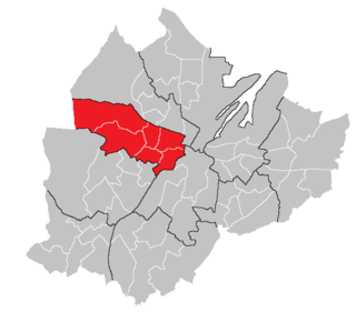
                Court is one of the ten district electoral areas (DEA) in Belfast, Northern Ireland. Located in the north and west of the city, the district elects six members to Belfast City Council and contains the wards of Ballygomartin, Clonard, Falls, Forth River, Shankill, and Woodvale. Court is split between the Belfast North and Belfast West constituencies for the Northern Ireland Assembly and UK Parliament.

                <span class="mw-page-title-main">Pottinger (District Electoral Area)</span> Human settlement in Northern Ireland

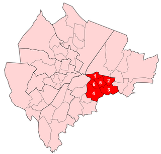
                Pottinger was one of the nine district electoral areas (DEA) in Belfast, Northern Ireland from 1985 to 2014. Located in the east of the city, the district elected six members to Belfast City Council and contained the wards of Ballymacarrett, Bloomfield, Orangefield, Ravenhill, The Mount, and Woodstock.

                <span class="mw-page-title-main">Victoria (District Electoral Area)</span> Electoral division in east Belfast, Northern Ireland

                Victoria was one of the nine district electoral areas (DEA) in Belfast, Northern Ireland, from 1985 to 2014, when it was mostly replaced by the Ormiston district.

                Elections to Carrickfergus Borough Council were held on 7 June 2001 on the same day as the other Northern Irish local government elections. The election used three district electoral areas to elect a total of 17 councillors.

                Elections to Carrickfergus Borough Council were held on 21 May 1997 on the same day as the other Northern Irish local government elections. The election used three district electoral areas to elect a total of 17 councillors.

                Elections to Carrickfergus Borough Council were held on 19 May 1993 on the same day as the other Northern Irish local government elections. The election used three district electoral areas to elect a total of 17 councillors.

                Elections to Carrickfergus Borough Council were held on 17 May 1989 on the same day as the other Northern Irish local government elections. The election used three district electoral areas to elect a total of 15 councillors.

                Bangor West is one of the seven district electoral areas (DEA) in Ards and North Down, Northern Ireland. The district elects five members to Ards and North Down Borough Council and contains the wards of Bryansburn, Kilcooley, Rathgael, Rathmore and Silverstream. Bangor West forms part of the North Down constituencies for the Northern Ireland Assembly and UK Parliament.

                Newtownards is one of the seven district electoral areas (DEA) in Ards and North Down, Northern Ireland. The district elects five members to Ards and North Down Borough Council and contains the wards of Conway Square, Cronstown, Glen, Gregstown, Movilla, Scrabo and West Winds. Newtownards forms part of the Strangford constituencies for the Northern Ireland Assembly and UK Parliament.

                Ballyholme and Groomsport was one of the four district electoral areas in North Down, Northern Ireland which existed from 1985 to 2014. The district elected six members to North Down Borough Council until 1993 and seven members until 2014, and formed part of the North Down constituencies for the Northern Ireland Assembly and UK Parliament.

                Castlereagh East is one of the seven district electoral areas (DEA) in Lisburn and Castlereagh, Northern Ireland. The district elects five members to Lisburn and Castlereagh City Council and contains the wards of Ballyhanwood, Carrowreagh, Dundonald, Enler, Graham's Bridge and Moneyreagh. Castlereagh East forms part of the Belfast East constituencies for the Northern Ireland Assembly and UK Parliament.

                Castlereagh Central was one of the district electoral areas in Castlereagh, Northern Ireland which existed from 1985 to 2014. It was one of three Castlereagh DEAs until 1993, and one of four until 2014. The district elected seven members to Castlereagh Borough Council from 1985 to 1993, and six members from 1993 to 2014. It formed part of the Strangford constituency until 1997, the Strangford and Belfast East constituencies from 1997 to 2010 and the Belfast East and Belfast South constituencies for the Northern Ireland Assembly and UK Parliament.

                Killultagh is one of the seven district electoral areas (DEA) in Lisburn and Castlereagh, Northern Ireland. The district elects five members to Lisburn and Castlereagh City Council and contains the wards of Ballinderry, Glenavy, Maghaberry, Stonyford and White Mountain. Killultagh forms part of the Lagan Valley constituencies for the Northern Ireland Assembly and UK Parliament, and part of the South Antrim constituencies for the Northern Ireland Assembly and UK Parliament.

                Downshire was one of the district electoral areas in Lisburn, Northern Ireland which existed from 1985 to 2014. It was one of four Lisburn DEAs until 1993, and one of five until 2014. The district elected seven members to Lisburn City Council from 1985 to 1993, and five members from 1993 to 2014, and formed part of Lagan Valley constituencies for the Northern Ireland Assembly and UK Parliament.

                Ballyclare is one of the seven district electoral areas (DEA) in Antrim and Newtownabbey, Northern Ireland. The district elects five members to Antrim and Newtownabbey Borough Council and contains the wards of Ballyclare East, Ballyclare West, Ballynure, Ballyrobert and Doagh. Ballyclare forms part of the South Antrim constituencies for the Northern Ireland Assembly and UK Parliament.

                Knockagh is one of the seven district electoral areas (DEA) in Mid and East Antrim, Northern Ireland. The district elects five members to Mid and East Antrim District Council and contains the wards of Burleigh Hill, Gortalee, Greenland, Sunnylands and Woodburn. Knockagh forms part of the East Antrim constituencies for the Northern Ireland Assembly and UK Parliament.

                Carrick Castle is one of the seven district electoral areas (DEA) in Mid and East Antrim, Northern Ireland. The district elects five members to Mid and East Antrim District Council and contains the wards of Boneybefore, Castle, Kilroot, Love Lane and Victoria. Carrick Castle forms part of the East Antrim constituencies for the Northern Ireland Assembly and UK Parliament.

                Larne Town was one of the three district electoral areas in Larne, Northern Ireland which existed from 1985 to 2014. The district elected five members to Larne Borough Council, and formed part of the East Antrim constituencies for the Northern Ireland Assembly and UK Parliament.

                The Mournes is one of the seven district electoral areas (DEA) in Newry, Mourne and Down, Northern Ireland. The district elects seven members to Newry, Mourne and Down District Council and contains the wards of Annalong, Binnian, Donard, Kilkeel, Lisnacree, Murlough and Tollymore. The Mournes forms part of the South Down constituencies for the Northern Ireland Assembly and UK Parliament.

                References

                1. "Kilroot Result Sheet" (PDF). EONI. Retrieved 8 July 2021.
                2. "Local Government Results 2005". EONI. Retrieved 8 July 2021.
                3. "Local Government Results 2001". EONI. Retrieved 8 July 2021.
                4. "Local Government Results 1997". EONI. Retrieved 8 July 2021.
                5. "Local Government Results 1993". EONI. Retrieved 8 July 2021.
                6. "Local Government Results 1989". EONI. Retrieved 8 July 2021.
                7. "Local Government Results 1985". EONI. Retrieved 8 July 2021.