
Masfjorden is a municipality in the northern part of Hordaland county in Norway. The municipality is located in the Nordhordland district of the county. The administrative centre of the municipality is the village of Masfjordnes. Other villages in the municipality include Frøyset, Hosteland, Matre, and Solheim.

Volda is a municipality in Møre og Romsdal county, Norway. It is part of the Sunnmøre region. The administrative centre is the village of Volda. Other villages in the municipality include Dravlaus, Folkestad, Fyrde, Lauvstad, and Straumshamn. The municipality is located about 50 kilometres (31 mi) south of the city of Ålesund.

Sørfold is a municipality in Nordland county, Norway. It is part of the traditional district of Salten. The administrative centre of the municipality is the village of Straumen. Other villages in the municipality include Leirfjordgården, Mørsvikbotn, Røsvika, Rørstad, Styrkesvik, and Øvre Kvarv. The municipality surrounds the Sørfolda fjord and stretches east to the border with Sweden.

Gratangen is a municipality in Troms county, Norway. It is part of the traditional region of Central Hålogaland. The administrative centre of the municipality is the village of Årstein.

The Hardangerfjord is the fourth longest fjord in the world, and the second longest fjord in Norway. It is located in Hordaland county in the Hardanger region. The fjord stretches 179 kilometres (111 mi) from the Atlantic Ocean into the mountainous interior of Norway along the Hardangervidda plateau. The innermost point of the fjord reaches the town of Odda.

Jøssingfjorden is a fjord in Sokndal municipality in Rogaland county, Norway. The 3-kilometre (1.9 mi) long fjord is narrow and deep and is surrounded by mountains. It sits about 4 kilometres (2.5 mi) southeast of the municipal centre of Hauge. There is some settlement on the southeastern side of the fjord: the villages of Li, Vinterstø, and Bu. There is a road that runs along the southeast coast of the fjord, with sharp hairpin turns leading down from the mountains to the shore of the fjord both heading north and south from the fjord.

Sjøvegan is the administrative centre of Salangen Municipality in Troms county, Norway. The village is located at the end of the Sagfjorden, a branch of the Salangen fjord. The river Salangselva empties into the fjord at Sjøvegan. The river flows through the lakes Nervatnet and Øvrevatnet just to the east of the village.

Andkjelvatnet is a lake that lies in the municipality of Sørfold in Nordland county, Norway. It is located in the southeastern part of the municipality of Sørfold, about 6 kilometres (3.7 mi) northeast of the village of Straumen. The water flows out through the Tørrfjordelva river into the Sørfolda fjord. Most of the water that would naturally flow into the lake from the lake Sisovatnet to the east is diverted to a hydroelectric power station on the lake Straumvatnet.

Hopvatnet is a lake in the municipality of Steigen in Nordland county, Norway. The 3.83-square-kilometre (1.48 sq mi) lake lies about 15 kilometres (9.3 mi) northeast of the village of Nordfold. The lake is located just above sea level and it empties into the nearby Nordfolda branch of the Folda fjord.

The Austefjorden is a fjord arm off of the Voldsfjorden in Volda Municipality in Møre og Romsdal county, Norway. The 11-kilometre (6.8 mi) long fjord lies in the Sunnmørsalpene mountains about 5 kilometres (3.1 mi) north of the mountain Eidskyrkja in the northeastern part of the municipality. The Austefjorden and the Kilsfjorden join together to form the Voldsfjorden. The village of Fyrde is located at the innermost part of the fjord. There are several small peninsulas and outcroppings that jut out into the fjord, giving the fjord a meandering S-shaped path.

Dalsfjorden is a fjord in Sogn og Fjordane county, Norway. It is located in the municipalities of Askvoll, Fjaler, and Gaular. It is one of the two main fjords that comprise the Sunnfjord region of the county. The fjord is about 40 kilometres (25 mi) long and it is generally about 0.5 to 1 kilometre wide.
The Folda or Folla is a fjord in Nordland county, Norway. The fjord is located in the municipalities of Bodø, Steigen, and Sørfold. The Folda empties into the Vestfjorden about 40 kilometres (25 mi) northeast of the town of Bodø. The fjord is about 9 kilometres (5.6 mi) wide in the west where it joins the Vestfjorden between the Kjerringøy and Leiranger peninsulas.

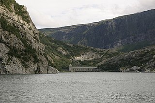
Folda or Folla is a firth and a fjord in Trøndelag county, Norway. It is located within the municipalities of Flatanger, Namsos, Fosnes, and Nærøy. The large wide firth is about 50 kilometres (31 mi) long which then narrows into a fjord which is about 75 kilometres (47 mi) long. The narrower fjord part of Folda is often called the Foldfjorden or Innerfolda. Most of the fjord is very narrow, some places with steep cliffs. It has the largest length to width factor among Norway's fjords. The fjord is crossed by the Norwegian County Road 17 road using the Folda Bridge at the village of Foldereid. Spruce forests cover most areas around the fjord. The outer-Folda area is notorious for its rough seas, and has been called an "ocean graveyard".
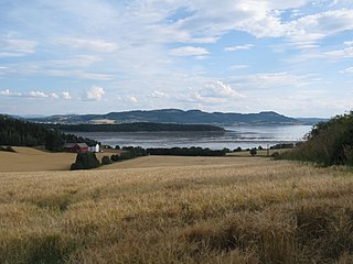
Beitstadfjorden is the innermost arm of the Trondheimsfjord in Trøndelag county, Norway. It is located in the municipalities of Steinkjer, Inderøy, and Verran. The fjord has a length of 28 kilometres (17 mi) from southwest to northeast, and a width of about 6 to 8 kilometres.
Glomfjorden is a fjord in the municipality of Meløy in Nordland county, Norway. The fjord is located just north of the Svartisen glacier between some very steep mountains that lie along the edges of the fjord. The villages of Glomfjord and Vassdalsvik are located along the fjord. The island of Messøya is located at the mouth of the fjord, near the village of Ørnes. The 21-kilometre (13 mi) long fjord is about 1 to 3 kilometres wide.
Andfjorden is a fjord on the border of Nordland and Troms counties in Norway. It primarily flows between the large islands of Andøya and Senja. Grytøya and the smaller islands Bjarkøya and Krøttøya are located in the fjord. The main crossing is via the Andenes–Gryllefjord Ferry between Andøy and Torsken municipalities. Other municipalities through which the fjord flows are Tranøy, Harstad, and Kvæfjord.

Fedafjorden is a fjord in Vest-Agder county, Norway. The 15-kilometre (9.3 mi) is located in the municipalities of Kvinesdal, Flekkefjord, and Farsund. The long, narrow fjord runs south from the mouth of the river Kvina to the Listafjorden.
Voldsfjorden or Voldafjorden is a fjord in Volda Municipality in Møre og Romsdal county, Norway. The 18-kilometre (11 mi) long fjord begins at the confluence of the Austefjorden and the Kilsfjorden.

Straumshamn is a village in Volda Municipality in Møre og Romsdal county, Norway. The village is located at the southern end of the Kilsfjorden branch of the Voldsfjorden. The Bjørkedalen valley runs south from Straumshamn cutting between the Sunnmørsalpene mountains. The village of Folkestad lies about 8 kilometres (5.0 mi) to the northwest and the village of Fyrde lies about 20 kilometres (12 mi) to the east. Kilsfjord Church is located in Straumshamn.

Kjerringøy is a former municipality in Nordland county, Norway. The 176-square-kilometre (68 sq mi) municipality existed from 1906 until its dissolution in 1964. The municipality included the coastal and island areas around the entrance to the Folda fjord, plus the northern coast of the Mistfjorden to the south of the Folda fjord. About 400 small islands totaling about 11 square kilometres (4.2 sq mi) were part of the municipality. The areas are located in what is now Bodø Municipality and a small part in Steigen Municipality. The administrative centre of the municipality was the village of Kjerringøy where Kjerringøy Church is located.


