
The Wupatki National Monument is a United States National Monument located in north-central Arizona, near Flagstaff. Rich in Native American archaeological sites, the monument is administered by the National Park Service in close conjunction with the nearby Sunset Crater Volcano National Monument. Wupatki was established as a national monument in 1924 and was listed on the National Register of Historic Places on October 15, 1966. The listing included three contributing buildings and 29 contributing structures on 35,422 acres (14,335 ha).

Chaco Culture National Historical Park is a United States National Historical Park in the American Southwest hosting a concentration of pueblos. The park is located in northwestern New Mexico, between Albuquerque and Farmington, in a remote canyon cut by the Chaco Wash. Containing the most sweeping collection of ancient ruins north of Mexico, the park preserves one of the most important pre-Columbian cultural and historical areas in the United States.

Casa Grande Ruins National Monument, in Coolidge, Arizona, just north-east of the city of Casa Grande, preserves a group of Hohokam structures dating to the Classic Period (1150–1450 CE).

El Cuartelejo, or El Quartelejo, is a region in eastern Colorado and western Kansas where Plains Apache cohabited with Puebloans. Subject to religious persecution, Puebloans fled the Spanish Nuevo México territory and cohabitated with the Cuartelejo villagers in the 1600s.
The Zuni Indian Reservation, also known as Pueblo of Zuni, is the homeland of the Zuni tribe of Native Americans. In Zuni language, the Zuni Pueblo people are referred to as A:shiwi, and the Zuni homeland is referred to as Halona Idiwan’a meaning Middle Place.
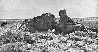
Hawikuh, was one of the largest of the Zuni pueblos at the time of the Spanish entrada. It was founded around 1400 AD. It was the first pueblo to be visited and conquered by Spanish explorers.

Casa Malpaís is an archaeological site of the Ancestral Puebloans located near the town of Springerville, Arizona. The site is a nationally recognized archaeological site and was declared a National Historic Landmark in 1964.

The Tusayan Ruins is an 800-year-old Pueblo Indian site located within Grand Canyon National Park, and is considered by the National Park Service (NPS) to be one of the major archeological sites in Arizona. The site consists of a small, u-shaped pueblo featuring a living area, storage rooms, and a kiva. Tree ring studies indicate that the site was occupied for about twenty years, beginning around 1185. It is found on the Desert View Drive portion of Arizona State Route 64, 3 miles west of the Desert View Watchtower. The site was listed on the National Register of Historic Places in 1974.

Salmon Ruins is an ancient Chacoan and Pueblo site located in the northwest corner of New Mexico, USA. Salmon was constructed by migrants from Chaco Canyon around 1090 CE, with 275 to 300 original rooms spread across three stories, an elevated tower kiva in its central portion, and a great kiva in its plaza. Subsequent use by local Middle San Juan people resulted in extensive modifications to the original building, with the reuse of hundreds of rooms, division of many of the original large, Chacoan rooms into smaller rooms, and emplacement of more than 20 small kivas into pueblo rooms and plaza areas. The site was occupied by ancient Ancestral Puebloans until the 1280s, when much of the site was destroyed by fire and abandoned. The pueblo is situated on the north bank of the San Juan River, just to the west of the modern town of Bloomfield, New Mexico, and about 45 miles (72 km) north of Pueblo Bonito in Chaco Canyon. The site was built on the first alluvial terrace above the San Juan River floodplain.
Kinishba Ruins is a 600-room Mogollon great house archaeological site in eastern Arizona and is administered by the White Mountain Apache Tribe. It is located on the present-day Fort Apache Indian Reservation, in the Apache community of Canyon Day. As it demonstrates a combination of both Mogollon and Ancestral Puebloan cultural traits, archaeologists consider it part of the historical lineage of both the Hopi and Zuni cultures. It is designated as a National Historic Landmark.

Pueblo Grande Ruin and Irrigation Sites are pre-Columbian archaeological sites and ruins, located in Phoenix, Arizona. They include a prehistoric platform mound and irrigation canals. The City of Phoenix manages these resources as the Pueblo Grande Museum Archaeological Park.

Mesa Grande Cultural Park, in Mesa, Arizona, preserves a group of Hohokam structures constructed during the Classic Period. The ruins were occupied between AD 1100 and 1400 and were a product of the Hohokam civilization that inhabited the Salt River Valley. There the Hohokam constructed an extensive system of water canals. It is one of only two Hohokam mounds remaining in the metro Phoenix area, with the other being the Pueblo Grande Museum Archaeological Park. The site's central feature is a massive ruin of adobe walls and platforms.

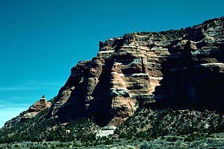
Tuzigoot National Monument preserves a 2- to 3-story pueblo ruin on the summit of a limestone and sandstone ridge just east of Clarkdale, Arizona, 120 feet above the Verde River floodplain. The Tuzigoot Site is an elongated complex of stone masonry rooms that were built along the spine of a natural outcrop in the Verde Valley. The central rooms stand higher than the others and they appear to have served public functions. The pueblo has 110 rooms. The National Park Service currently administers 58 acres, within an authorized boundary of 834 acres.
Bailey Ruin is an archaeological site located in Navajo County, Arizona, United States. The site, also known as "Stott Ranch Ruin" and "Pope Ranch Site," was added to the National Register of Historic Places on March 17, 2006 for its historical and archaeological significance.
Wide Ruins is a chapter of the Navajo Nation and a census-designated place (CDP) in Apache County, Arizona, United States. The population was 176 at the 2010 census.
Cosmos Mindeleff (1863–1938) started his career as assistant to his brother Victor Mindeleff, who was employed by the Bureau of American Ethnology to conduct studies of Pueblo architecture in the 1880s. In 1882, James Stevenson and the Mindeleffs visited Canyon de Chelly and Canyon del Muerto. In later years, Victor and Cosmos Mindeleff continued their research in Canyon de Chelly and Cosmos published the first authoritative archeological map of White House Ruins in 1893.

Eagar Townsite Historic District is a section of the town of Eagar, Arizona which has been designated a National Historic Place. Sitting on roughly 54 acres, the site contains 37 structures, 21 of which have historical significance. The period of significance is from 1886, the year the townsite was founded, through 1942, which represents the significant period of development of the town. The site was added to the Register on July 23, 1993.
The Lower Zuni River Archeological District is an area of approximately 29,500 acres, comprising 89 distinct archeological sites. It is located approximately 24 miles northeast of St. Johns, Arizona, at the Arizona–New Mexico border, along the Zuni River.

Puerco Ruin and Petroglyphs are the ruins of a large Indian pueblo, which reached its peak around 1300 CE, containing over 100 rooms. It is the largest known archeological site within the Petrified Forest National Park.

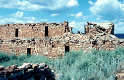
Sherwood Ranch Pueblo is an historic pueblo located overlooking the Little Colorado River, near Springerville, Arizona. It has two areas of habitation, consisting of over 800 rooms and was inhabited from approximately 1000-1450 A.D.


