
Falmouth is a home rule-class city in, and the county seat of, Pendleton County, Kentucky, in the United States. The population was 2,169 according to the 2010 census. It lies at the confluence of the South and Main forks of the Licking River and is home to Kincaid Regional Theatre.

The Wilderness Road was one of two principal routes used by colonial and early national era settlers to reach Kentucky from the East. Although this road goes through the Cumberland Gap into southern Kentucky and northern Tennessee, the other is sometimes called the "Cumberland Road" because it started in Fort Cumberland in Maryland. Despite Kentucky Senator Henry Clay's advocacy of this route, early in the 19th century, the northern route was selected for the National Road, connecting near Washington, Pennsylvania into the Ohio Valley of northern Kentucky and Ohio.

Wickliffe Mounds is a prehistoric, Mississippian culture archaeological site located in Ballard County, Kentucky, just outside the town of Wickliffe, about 3 miles (4.8 km) from the confluence of the Ohio and Mississippi rivers. Archaeological investigations have linked the site with others along the Ohio River in Illinois and Kentucky as part of the Angel phase of Mississippian culture. Wickliffe Mounds is controlled by the State Parks Service, which operates a museum at the site for interpretation of the ancient community. Listed on the National Register of Historic Places, it is also a Kentucky Archeological Landmark and State Historic Site.

Nolin River Lake is a reservoir in Edmonson, Grayson, and Hart counties in Kentucky. It was impounded from the Nolin River by the United States Army Corps of Engineers in 1963. The Nolin River dam was authorized in 1938 as part of a flood control act. The lake varies from 2,890 acres (11.7 km2) in the winter to 5,795 acres (23.5 km2) in the summer.
Buckhorn Lake, located south of Buckhorn, Kentucky, United States and northwest of Hazard, Kentucky off Kentucky Route 28, is a 1,230-acre (5 km2) reservoir created by the United States Army Corps of Engineers in 1967 by impounding the Middle Fork of the Kentucky River. The lake was flooded over top of a small township called Bowlingtown.
Lake Beshear is a 760-acre (3.1 km2) reservoir located in Caldwell and Christian counties in Kentucky. Impounded in 1962, the lake lies within the Pennyrile Forest State Resort Park.

Carr Creek Lake, located east of Hazard, Kentucky, along Kentucky Route 15 in Knott County, is a 710 acres (3 km2) reservoir created by the U.S. Army Corps of Engineers in 1976. Carr Creek Lake's earth and rock fill dam is 130 ft (40 m) tall and 720 ft (219 m) long, and the dam is located 8.8 mi (14 km) above the mouth of Carr Fork River, a tributary of the North Fork Kentucky River.
Greenbo Lake is a 181-acre (0.73 km2) reservoir nestled in the Appalachian foothills of Greenup County, Kentucky. The lake was jointly created in 1955 by the Greenbo Lake Association and the Kentucky Department of Fish and Wildlife Resources. Its distinctive name derives from the combination of the names of the county it is located in and nearby Boyd County. The association held a competition for the naming of this lake and the winner picked the name.

Dewey Lake, located near Prestonsburg, Kentucky in Floyd County, is part of the integrated flood reduction system operated by the United States Army Corps of Engineers for the entire Ohio River Basin.
Fishtrap Lake is a 1,130-acre (5 km2) reservoir in Pike County, Kentucky. Dedicated by President Lyndon B. Johnson in 1968, the lake was formed by the impounding of the Levisa Fork of the Big Sandy River at the 195-foot-high Fishtrap Dam by the United States Army Corps of Engineers.

Grayson Lake is a 1,500-acre (6.1 km2) reservoir in Carter and Elliott counties in Kentucky. It was created by the United States Army Corps of Engineers in 1968 by impounding the Little Sandy River with the Grayson Dam, an earthen structure 120 feet (37 m) high, creating a maximum capacity of 118,990 acre-feet (146,770,000 m3). Sections of Kentucky Route 7 were re-routed as a result of the lake's creation. KY 7 now traverses a modern highway stretch around the park, crossing the dam also.
Buckhorn Lake State Resort Park is a state park located in the northwest corner of Perry County, Kentucky. The park itself encompasses 856 acres (346 ha), while Buckhorn Lake, a mountain reservoir lake which serves as its major feature and which was created by damming the Middle Fork of the Kentucky River, covers approximately 1,230 acres (500 ha). The park is adjacent to the northern edge of the Daniel Boone National Forest.
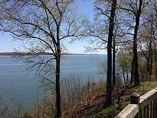
Kenlake State Resort Park is a park located on the western shore of Kentucky Lake. The park's main entrance and most of its facilities are located in Marshall County; the park also extends into Calloway County. The mailing address of the park is Hardin, Kentucky; however, it is located much closer to the unincorporated community of Aurora, Kentucky. The nearest town of substantial size is Murray. The park encompasses 1,795 acres (726 ha) of land, 160,300 acres (64,900 ha) of water, and features climate-controlled indoor tennis courts. It was Kentucky's first state resort park. Along with Lake Barkley State Resort Park and Kentucky Dam Village State Resort Park, Kenlake State Resort Park is part of the Land Between the Lakes National Recreation Area, originally organized by the Great Depression–era Tennessee Valley Authority (TVA).
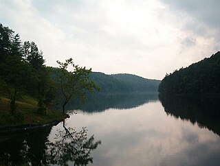
Kincaid Lake State Park is a park located near Falmouth, Kentucky in Pendleton County. The park encompasses 850 acres (340 ha) surrounding Kincaid Lake.

Paintsville Lake is a 1,139-acre (4.61 km2) reservoir in Johnson and Morgan counties in eastern Kentucky. It was impounded from Paint Creek in 1983 by the United States Army Corps of Engineers. It is the major attraction of Paintsville Lake State Park.
Lake Malone is a 788-acre (3.19 km2) reservoir in Logan, Muhlenberg, and Todd counties in Kentucky. It was impounded from Rocky Creek in 1961 and named for Mr. and Mrs. Wallace C. Malone who donated a large tract of land for the lake.

The Tolu Site is a prehistoric archeological site of the Mississippian culture near the unincorporated community of Tolu, Crittenden County, Kentucky, United States. It was built and occupied between 1200-1450 CE. No carbon dating has been performed at the site, but analysis of pottery styles suggest its major habitation period was 1200 to 1300 CE. The site originally had three mounds, a burial mound, a substructure platform mound and one other of undetermined function. It was excavated in 1930 by W.S. Webb and William D. Funkhouser.

The Rowlandton Mound Site (15MCN3) is a Mississippian culture archaeological site located in Paducah in McCracken County, Kentucky, on the edge of an old oxbow lake a little south of the Ohio River.


