King Salmon River (Admiralty Island)

Last updated
King Salmon River
Relief map of USA Alaska.png
Red pog.svg
Location of the mouth of the King Salmon River in Alaska
Location
Country United States
State Alaska
Census Area HoonahAngoon
Physical characteristics
Source Admiralty Island
 - location Kootznoowoo Wilderness, Admiralty Island National Monument
 - coordinates 58°03′41″N134°32′22″W / 58.06139°N 134.53944°W / 58.06139; -134.53944
 - elevation2,847 ft (868 m) [1]
River mouth King Salmon Bay, Seymour Canal
 - location18 miles (29 km) south of Juneau
 - coordinates 58°02′31″N134°20′27″W / 58.04194°N 134.34083°W / 58.04194; -134.34083 Coordinates: 58°02′31″N134°20′27″W / 58.04194°N 134.34083°W / 58.04194; -134.34083 [2]
 - elevation10 ft (3.0 m) [2]
Length11 mi (18 km) [2]

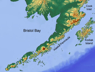
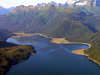
The King Salmon River is a small stream on the northern tip of Admiralty Island of Southeast Alaska, United States.

Admiralty Island island in the United States of America

Admiralty Island is an island in the Alexander Archipelago in Southeast Alaska, at 57°44′N134°20′W. It is 145 km (90 mi) long and 56 km (35 mi) wide with an area of 4,264.1 km2 (1,646.4 sq mi), making it the seventh largest island in the United States and the 132nd largest island in the world. It is one of the ABC islands of Alaska. The island is nearly cut in two by the Seymour Canal; to its east is the long, narrow Glass Peninsula. Most of Admiralty Island—more than 955,000 acres (3,860 km2)—is occupied by the Admiralty Island National Monument - a federally protected wilderness area administered by the Tongass National Forest. The Kootznoowoo Wilderness encompasses vast stands of old growth temperate rainforest. These forests provide some of the best habitat available to species such as brown bears, bald eagles, and Sitka black-tailed deer.

Southeast Alaska

Southeast Alaska, sometimes referred to as the Alaska Panhandle, is the southeastern portion of the U.S. state of Alaska, bordered to the east by the northern half of the Canadian province of British Columbia. The majority of Southeast Alaska's area is part of the Tongass National Forest, the United States' largest national forest. In many places, the international border runs along the crest of the Boundary Ranges of the Coast Mountains. The region is noted for its scenery and mild rainy climate.

It flows eastward then south for a total distance of 11 miles (18 km) from headwaters in the low mountains just south of Eagle Peak into King Salmon Bay of the Seymour Canal. Its entire course lies within Kootznoowoo Wilderness of the Admiralty Island National Monument.

Seymour Canal

Seymour Canal is an inlet penetrating deep into the southeastern part of Admiralty Island, Southeast Alaska, United States. The inlet was first charted in 1794 by Joseph Whidbey, master of HMS Discovery during George Vancouver's 1791–95 expedition. Vancouver later named it "Seymour's Channel". Two large islands are located within it: Swan Island to the north, and Tiedeman Island just to its south.

Kootznoowoo Wilderness


The temperate rainforests of Admiralty Island's Kootznoowoo Wilderness are unique among the 5,700,000 acres (2,300,000 ha) of federally protected Wilderness in Southeast Alaska.

Admiralty Island National Monument

Admiralty Island National Monument is a United States National Monument located on Admiralty Island in Southeast Alaska, and is managed as part of the Tongass National Forest. It was created December 1, 1978, and covers 955,747 acres (3,868 km2) in Southeast Alaska. The remoteness of the monument led Congress to pass legislation designating all but 18,351 acres (74 km2) of the monument as the Kootznoowoo Wilderness, ensuring that the vast bulk of this monument is permanently protected from development. The monument is administered by the U.S. Forest Service from offices in Juneau.

A relatively small river, it is not navigable. Besides its namesake king salmon, the river hosts a large annual run of pink salmon.

Pink salmon species of fish

Pink salmon or humpback salmon is a species of anadromous fish in the salmon family. It is the smallest and most abundant of the Pacific salmon. The scientific species name is based on the Russian common name for this species gorbúša (горбуша), which literally means humpie.

See also

Related Research Articles

The Salmon River is the name of several different rivers:

Time in the United States Timekeeping in the USA

Time in the United States, by law, is divided into nine standard time zones covering the states and its possessions, with most of the United States observing daylight saving time (DST) for approximately the spring, summer, and fall months. The time zone boundaries and DST observance are regulated by the Department of Transportation. Official and highly precise timekeeping services (clocks) are provided by two federal agencies: the National Institute of Standards and Technology (NIST) ; and its military counterpart, the United States Naval Observatory (USNO). The clocks run by these services are kept synchronized with each other as well as with those of other international timekeeping organizations.

Kodiak Island island in the United States of America

Kodiak Island is a large island on the south coast of the U.S. state of Alaska, separated from the Alaska mainland by the Shelikof Strait. The largest island in the Kodiak Archipelago, Kodiak Island is the second largest island in the United States and the 80th largest island in the world, with an area of 9,311.24 km2 (3,595.09 sq mi), slightly larger than Cyprus. It is 160 km long and in width ranges from 16 to 97 kilometers. Kodiak Island is the namesake for Kodiak Seamount, which lies off the coast at the Aleutian Trench. The largest community on the island is the city of Kodiak, Alaska.

Alaska Peninsula peninsula extending about 800 km (497 mi) to the southwest from the mainland of Alaska and ending in the Aleutian Islands

The Alaska Peninsula is a peninsula extending about 800 km (497 mi) to the southwest from the mainland of Alaska and ending in the Aleutian Islands. The peninsula separates the Pacific Ocean from Bristol Bay, an arm of the Bering Sea.

Bristol Bay easternmost arm of the Bering Sea, at 57° to 59° North 157° to 162° West in Southwest Alaska; 400 km long, 290 km, wide at its mouth; rivers flowing into it include the Cinder, Egegik, Igushik, Kvichak, Meshik, Nushagak, Naknek, Togiak, and Ugashik

Bristol Bay is the eastern-most arm of the Bering Sea, at 57° to 59° North 157° to 162° West in Southwest Alaska. Bristol Bay is 400 km (250 mi) long and 290 km, (180 mi) wide at its mouth. A number of rivers flow into the bay, including the Cinder, Egegik, Igushik, Kvichak, Meshik, Nushagak, Naknek, Togiak, and Ugashik.

Nushagak River river in the United States of America

The Nushagak River is a river in southwest Alaska, United States. It begins in the Alaska Range and flows southwest 450 km (280 mi) to Nushagak Bay, an inlet of Bristol Bay, east of Dillingham, Alaska.

Iliamna Lake lake in southwest Alaska

Iliamna Lake or Lake Iliamna is a lake in southwest Alaska, at the north end of the Alaska Peninsula, between Kvichak Bay and Cook Inlet, about 100 miles (160 km) west of Seldovia, Alaska.

Ugashik River watercourse

The Ugashik River is a stream, 43 miles (69 km) long, on the Alaska Peninsula of the U.S. state of Alaska. It flows from headwaters near Lower Ugashik Lake and empties into Ugashik Bay, an estuary of the Bering Sea's Bristol Bay.

Southwest Alaska

Southwest Alaska is a region of the U.S. state of Alaska. The area is not exactly defined by any governmental administrative region(s); nor does it always have a clear geographic boundary.

Egegik River river in Alaska, United States

The Egegik River is a waterway in the U.S. state of Alaska. A biological survey was conducted at the base of the Alaska Peninsula in 1902 by Wilfred Hudson Osgood, which included the Egegik River.

King Salmon River (Ugashik River tributary) river in Alaska

The King Salmon River is a 35-mile (56 km) tributary of the Ugashik River in the U.S. state of Alaska. Beginning at Mother Goose Lake in the Aleutian Range, it flows northwest to meet the larger river near the upper reaches of Ugashik Bay. The lake and the upper course of the King Salmon lie within the Alaska Peninsula National Wildlife Refuge. The river's gravel bottom and braided channels are ideal for the many king salmon that spawn in its waters, but they limit navigation to small skiff.

Geography of Alaska

Alaska is one of two U.S. states not bordered by another state; Hawaii the other. Alaska has more ocean coastline than all of the other U.S. states combined. About 500 miles (800 km) of Canadian territory separate Alaska from Washington State. Alaska is thus an exclave of the United States that is part of the continental U.S. and the U.S. West Coast, but is not part of the contiguous U.S. Alaska is also the only state, other than Hawaii, whose capital city is accessible only via ship or air, because no roads connect Juneau to the rest of the continent.

King Salmon River (Nushagak River tributary) river in the United States of America

The King Salmon River is a 45-mile (72 km) tributary of the Nushagak River in southwest Alaska, United States. It flows eastward from headwaters 60°17′06″N158°28′33″W at a small unnamed lake in the Taylor Mountains to its confluence with the larger river about 220 miles (354 km) north of Nushagak Bay.

Windham Bay

Windham Bay is located 45 miles (72 km) southeast of Juneau, in the U.S. state of Alaska. Windham Bay is listed as site 6 within Southeast Alaska's Zone 3 of the Alaska Dept. of Environmental Conservation's Geographic Response Strategy oil spill response plan. Part of the bay is a protected wilderness area; the Chuck River Wilderness, established in 1990 by the United States Congress, covers an area of 74,506 acres (30,152 ha). The Chuck River flows into Windham Bay, which has a protected anchorage north of Port Houghton, where the historic Chuck Mining Camp once operated.

Kootznahoo Inlet waterway in Alaska

Kootznahoo Inlet is located on the eastern shore of Chatham Strait in the U.S. state of Alaska. Comprising an area of about 15 square miles (39 km2), it is an intricate group of narrow passages, lagoons, and bays, having its entrance 3 miles (4.8 km) north of Killisnoo. Kootznahoo, which means bear fortress, is also the name given by the Tlingit to mean Admiralty. The Kootznoowoo Wilderness also of the Admiralty Island covers some of the largest reserve areas covering about 1 million acres. The island is inhabited by about 1500 brown bears, the largest number recorded anywhere on the earth.

Port Snettisham Fjord in Alaska, United States

Port Snettisham is a narrow fjord 30 miles (48 km) southeast of Juneau in the U.S. state of Alaska. It is a semi protected deep water port that was developed to transport many mineral deposits found in the Snettisham Peninsula. Lieutenant Joseph Whidbey of the Royal Navy discovered the fjord on August 12, 1794; George Vancouver named it after the town of Snettisham in England.

References

  1. Derived by entering source coordinates in Google Earth.
  2. 1 2 3 "King Salmon River". Geographic Names Information System. United States Geological Survey. March 31, 1981. Retrieved January 15, 2014.