
Bloomsbury is a district in the West End of London, part of the London Borough of Camden in England. It is considered a fashionable residential area, and is the location of numerous cultural, intellectual, and educational institutions. Bloomsbury is home of the British Museum, the largest museum in the United Kingdom, and several educational institutions, including University College London and a number of other colleges and institutes of the University of London as well as its central headquarters, the New College of the Humanities, the University of Law, the Royal Academy of Dramatic Art, the British Medical Association and many others. Bloomsbury is an intellectual and literary hub for London, as home of world-known Bloomsbury Publishing, publishers of the Harry Potter series, and namesake of the Bloomsbury Group, a group of British intellectuals which included author Virginia Woolf, biographer Lytton Strachey, and economist John Maynard Keynes.

Clerkenwell is an area of central London, England.
Finsbury is a district of Central London, forming the southeastern part of the London Borough of Islington. It borders the City of London.

Islington is a district in the north of Greater London, England, and part of the London Borough of Islington. It is a mainly residential district of Inner London, extending from Islington's High Street to Highbury Fields, encompassing the area around the busy High Street, Upper Street, Essex Road, and Southgate Road to the east.

The Barbican Estate, or Barbican, is a residential complex of around 2,000 flats, maisonettes, and houses in central London, England, within the City of London. It is in an area once devastated by World War II bombings and densely populated by financial institutions, 1.4 miles (2.2 km) north east of Charing Cross. Originally built as rental housing for middle and upper-middle-class professionals, it remains an upmarket residential estate. It contains, or is adjacent to, the Barbican Arts Centre, the Museum of London, the Guildhall School of Music and Drama, the Barbican public library, the City of London School for Girls and a YMCA, forming the Barbican Complex.
Aldersgate is a Ward of the City of London, England, named after one of the northern gates in the London Wall which once enclosed the City.

Goswell Road, in Central London, is an end part of the A1. The southern part ends with one block, on the east side, in City of London; the rest is in the London Borough of Islington, the north end being Angel. It crosses Old Street/Clerkenwell Road. In the north it splits Clerkenwell from Finsbury; the south was sometimes used as a demarcator but all but the southern corporate/legal/financial end in the modern era forms the heart of the highly developed mixed-use district Barbican.

Hackney Central is a sub-district of Hackney in the London Borough of Hackney in London, England and is four miles (6.4 km) northeast of Charing Cross.

St Luke's is an area in London, England and is located in the London Borough of Islington. It lies just north of the border with the City of London near the Barbican Estate, and the Clerkenwell and Shoreditch areas.
Lisson Grove is a street and district in the City of Westminster, West London. The West End neighbourhood contains a few important cultural landmarks, including Lisson Gallery, Alfies Antique Market, Red Bus Recording Studios, the former Christ Church, now the Greenhouse Centre, and the Seashell of Lisson Grove.
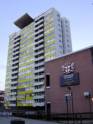
The Golden Lane Estate is a 1950s council housing complex in the City of London. It was built on the northern edge of the City, on a site devastated by bombing during the Second World War. Since 1997, the estate has been protected as a group of listed buildings of special architectural interest.

Charterhouse Square is a garden square, a pentagonal space, in Farringdon, in the London Borough of Islington, and close to the former Smithfield Meat Market. The square is the largest courtyard or yard associated with the London Charterhouse, mostly formed of Tudor and Stuart architecture restored after the London Blitz. The square adjoins other buildings including a small school. It lies between Charterhouse Street, Carthusian Street and the main Charterhouse complex of buildings south of Clerkenwell Road. The complex includes a Chapel, Tudor Great Hall, Great Chamber, the Barts and The London School of Medicine and Dentistry and a 40-resident almshouse.
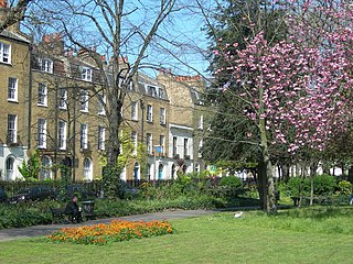
Clapton Square is the second largest garden square in the London Borough of Hackney, located in Lower Clapton, Clapton. It is lined by buildings on three sides. Its Conservation Area designated in 1969 – extended in 1991 and 2000 – takes in a larger green space separated by a stretch of open road: St John's Gardens. Those gardens have the tallest and largest building visible from all parts of the square's garden, the Church of St John-at-Hackney, rebuilt in 1792-97 which contains older monuments. Two sides of the square are lined with tall, partly stone-dressed, classical, Georgian terraced houses.

Northampton Square, a green town square, is in a corner of Clerkenwell projecting into Finsbury, in Central London. It is between Goswell Road and St John Street, has a very broad pedestrian walkway on the north-west side between university buildings and is fronted chiefly by main buildings of City, University of London.

Woodford is a town in East London, England, within the London Borough of Redbridge. It is located 9.5 miles (15.3 km) north-east of Charing Cross. Woodford historically formed an ancient parish in the county of Essex. It contained a string of agrarian villages and was part of Epping Forest. From about 1700 onwards, it became a place of residence for affluent people who had business in London; this wealth, together with its elevated position, has led to it being called the Geographical and social high point of East London. Woodford was suburban to London and after being combined with Wanstead in 1934 it was incorporated as a municipal borough in 1937. It has formed part of Greater London since 1965 and comprises the neighbourhoods of Woodford Green, Woodford Bridge, Woodford Wells and South Woodford. The area is served by two stations on the Central line of the London Underground: Woodford and South Woodford.

St Peter's Square, in Hammersmith, London, England, is a garden square laid out in the 1820s, just north of the River Thames between the Great West Road (A4) and King Street, within the St Peter's Square Conservation Area and London Borough of Hammersmith and Fulham.

St. Andrews Square is a mainly 1876 to 1884-built garden square in Surbiton in the borough of Kingston upon Thames, London.

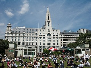
The Angel is an area on the northern fringes of Central London within the London Borough of Islington. It is 2 miles (3.2 km) north-northeast of Charing Cross on the Inner Ring Road at a busy transport intersection. The area is identified in the London Plan as one of 35 major centres in London. It is a significant commercial and retail centre, and a business improvement district. The Angel straddles the ancient boundary of the parishes of Clerkenwell and Islington that later became the metropolitan boroughs of Finsbury and Islington. It is named from the former Angel Inn which stood on the corner of Islington High Street and Pentonville Road. Since 1965 the whole area has formed part of the London Borough of Islington in Greater London.

King Square Gardens is a park in the area of St Luke's in the London Borough of Islington, to the west of King Square. The park is designated as a Site of Local Importance to Nature Conservation. The park was used in the opening scene of the Pink Floyd song Another Brick in the Wall Part 2 from 1979.

St Clement's Church, King Square, is a Church of England parish church in Finsbury, Central London, in the London Borough of Islington. It is adjacent to King Square, within a walking distance from City Road.
