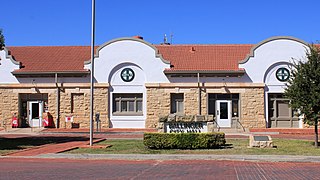
Ballinger is a city in Runnels County, Texas, United States. The population was 3,767 at the 2010 census. It is the county seat of Runnels County.
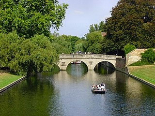
The River Cam is the main river flowing through Cambridge in eastern England. After leaving Cambridge, it flows north and east into the Great Ouse to the south of Ely at Pope's Corner. The Great Ouse connects the Cam to the North Sea at King's Lynn: The total distance from Cambridge to the sea is about 40 mi (64 km) and is navigable for punts, small boats, and rowing craft. The Great Ouse also connects to England's canal system via the Middle Level Navigations and the River Nene. In total, the Cam runs for around 69 kilometres (43 mi) from its furthest source to its confluence with the Great Ouse.
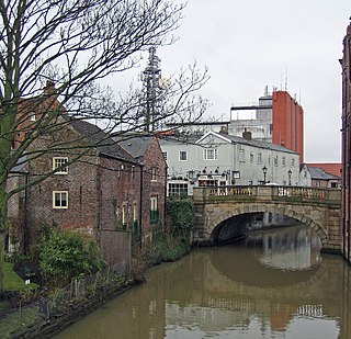
The River Foss is in North Yorkshire, England. It is a tributary of the River Ouse. It rises in the Foss Crooks Woods near Oulston Reservoir close to the village of Yearsley and runs south through the Vale of York to the Ouse in the centre of York. The name most likely comes from the Latin word Fossa, meaning ditch. It is mentioned in the Domesday Book. The York district was settled by Norwegian and Danish people, so parts of the place names could be old Norse. Referring to the etymological dictionary "Etymologisk ordbog", ISBN 82-905-2016-6 dealing with the common Danish and Norwegian languages – roots of words and the original meaning. The old Norse word Fos (waterfall) meaning impetuous. The River Foss was dammed, and even though the elevation to the River Ouse is small, a waterfall was formed. This may have led to the name Fos which became Foss.
Cumberland is a historic county in North West England that had an administrative function from the 12th century until 1974. It is bordered by the historic counties of Northumberland to the northeast, County Durham to the east, Westmorland to the southeast, Lancashire to the south, and the Scottish counties of Dumfriesshire and Roxburghshire to the north. It formed an administrative county from 1889 to 1974 and now forms part of Cumbria. In April 2023 local government in Cumbria will be reorganised into two unitary authorities, one of which is to be named Cumberland and would include most of the historic county, with the exception of Penrith and the surrounding area.

The River Plym is a river in Devon, England. It runs from Dartmoor in the centre of the county southwest to meet the River Meavy, then south towards Plymouth Sound. The river is popular with canoeists, and the Plym Valley Railway runs alongside a section of the river.

The Six Mile Water is a river in southern County Antrim, Northern Ireland. It is an indirect tributary of the River Bann, via Lough Neagh.

Gzennya or Igzennayen is the name of many Berber tribes and places in the mountainous Rif region in northern Morocco.

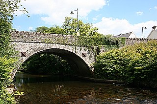
The River Lowther is a small river which flows through limestone rock in Cumbria, England. It is a tributary of the River Eamont which in turn is a tributary of the River Eden which flows into the Solway Firth near Carlisle. The Lowther begins with the confluence of the Keld Gill and the Keld Dub near the village of Keld. It flows north-west until it passes between Bampton and Bampton Grange, before turning north until it flows into the River Eamont close to Penrith.

The River Ehen is a river in Cumbria, England.

Lanesborough–Ballyleague, more commonly known simply as Lanesborough, is a town in the midlands of Ireland. Lanesborough is on the County Longford (east) side and Ballyleague on the County Roscommon (west) side of the River Shannon. They are located at the northern tip of Lough Ree on the N63 national secondary road at its junction with the R371 and R392. The town of Longford is 16 km north-east on the N63, the town of Roscommon is 15 km south-west on the N63, the town of Ballymahon is 20 km south-east on the R392 and the town of Strokestown is 15 km north-west on the R371.

The River Mourne is a river in County Tyrone, Northern Ireland, and is a tributary of the River Foyle It is formed at the meetings of the River Derg and River Strule below Ardstraw. At Strabane it joins with the River Finn to form the River Foyle. Fishing is largely for salmon, grilse and sea trout. Other species such as Common Roach, Common Minnow, Northern Pike, European Eel, Perch and Sticklebacks can also be found in different stretches of the River on occasion.

The River Leader, or Leader Water, is a small tributary of the River Tweed in Lauderdale in the Scottish Borders. It flows southwards from the Lammermuir Hills through the towns of Lauder and Earlston, joining the River Tweed at Leaderfoot.

Brampton Town railway station was the terminus of the Brampton Town Branch, in the centre of Brampton, Cumbria, England. It was opened in 1775, to work on the Earl of Carlisle's Waggonway. By 1836, a horse-driven passenger service had been implemented when the track was realigned to meet up with the Newcastle and Carlisle Railway, providing a service to Milton station, now Brampton (Cumbria) station, about a mile out of town.
Aleksandria is a village in the administrative district of Gmina Konopiska, within Częstochowa County, Silesian Voivodeship, in southern Poland. It lies approximately 14 kilometres (9 mi) south-west of Częstochowa and 54 km (34 mi) north of the regional capital Katowice.
Glenelly River is a river in County Tyrone, Northern Ireland. It flows westwards along the long linear Glenelly Valley to the south of Sawel Mountain, following one of the principal fault-lines in the Sperrin Mountains. The river meanders across a complex, undulating floodplain of alluvium and glacial moraine. The channel has often carved deep ridges within these soft deposits, creating steep, irregular mounds and pockets of peaty marsh on the valley floor. The otter has been recorded in the Glenelly River, which is important also for salmon and trout. The village of Plumbridge stands on the banks of the Glenelly River which flows on to join the Owenkillew River near Newtownstewart.

Wetherby Ings are water meadows, by the River Wharfe now used as parkland in Wetherby, West Yorkshire, England. The ings on the north and south bank are used as parkland and for sports grounds for the town's football and rugby league teams. The area is liable to flooding during heavy rain and the river has broken its banks frequently.
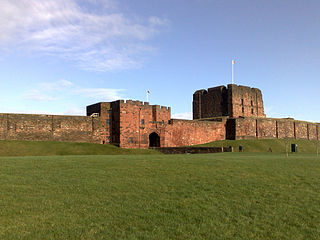
The Siege of Carlisle took place from 22 July to 1 August 1315, during the First War of Scottish Independence, near the town of Carlisle, in Cumbria, England.
The Welsh Salmon and Trout Angling Association (WSTAA) is the governing body for game angling in Wales. It has about one hundred member clubs. Founded as the Welsh Fly Fishing Association in 1952, the WSTAA organises national and international angling competitions, including two major World Fly Fishing Championships and the 2002 Commonwealth championship in Wales—the WSTAA Wales team won gold at the 2009 IFFA River International competition. The WSTAA also highlights issues that affect Welsh anglers including: game fishing conservation; threats to water quality from acid rain; water pollution; barrages; poaching; stocking; and 'Objective One' funding.

Rose Castle is a 16,244 square feet (1,509.1 m2) fortified house in Cumbria, England, on a site that was home to the bishops of Carlisle from 1230 to 2009. It is within the parish of Dalston, 1.5 miles (2.4 km) from Dalston itself, which is four miles southwest of Carlisle. The architects Anthony Salvin and Thomas Rickman were responsible for the alterations which took place in the 19th century.

Padbury Brook is a stream/river in Oxfordshire and Buckinghamshire; it is a small tributary of the River Great Ouse approximately 12 km in length.
