
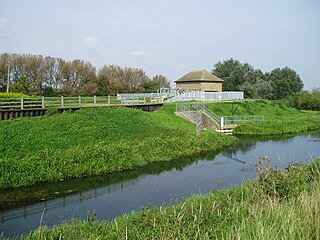
The River Welland is a lowland river in the east of England, some 65 miles (105 km) long. It drains part of the Midlands eastwards to The Wash. The river rises in the Hothorpe Hills, at Sibbertoft in Northamptonshire, then flows generally northeast to Market Harborough, Stamford and Spalding, to reach The Wash near Fosdyke. It is a major waterway across the part of the Fens called South Holland, and is one of the Fenland rivers which were laid out with washlands. There are two channels between widely spaced embankments with the intention that flood waters would have space in which to spread while the tide in the estuary prevented free egress. However, after the floods of 1947, new works such as the Coronation Channel were constructed to control flooding in Spalding and the washes are no longer used solely as pasture, but may be used for arable farming.
The River Glen is a river in Lincolnshire, England with a short stretch passing through Rutland near Essendine.

Spalding /ˈspɒldɪŋ / is a market town with a population of 28,722 at the 2011 census, on the River Welland in the South Holland district of Lincolnshire, England. Little London is a hamlet directly south of Spalding on the B1172, whilst Pinchbeck, a village to the north, is part of the built-up area.

Stamford is a town on the River Welland in Lincolnshire, England, 92 miles (148 km) north of London on the A1. The population at the 2011 census was 19,701. The town has 17th and 18th-century stone buildings, older timber-framed buildings and five medieval parish churches. Stamford is a frequent filming location. In 2013 it was rated the best place to live in a survey by The Sunday Times.
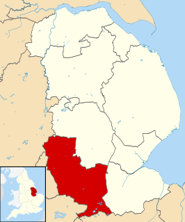
South Kesteven is a local government district in Lincolnshire, England, forming part of the traditional Kesteven division of the county. It covers Grantham, Stamford, Bourne and Market Deeping. The 2011 census reports 133,788 people at 1.4 per hectare in 57,344 households.

Welland County is a historic county in the Canadian province of Ontario.
The Deepings are a series of settlements close to the River Welland near the borders of southern Lincolnshire and north western Cambridgeshire near the city of Peterborough and between the towns of Spalding and Stamford in eastern England.

King Street is the name of a modern road on the line of a Roman road. It runs on a straight course in eastern England, between the City of Peterborough and South Kesteven in Lincolnshire. This English name has long been applied to the part which is still in use and which lies between Ailsworth Heath, in the south and Kate's Bridge, in the north. The old road continued to Bourne thence north-westwards to join Ermine Street south of Ancaster. This part of Ermine Street is called High Dike. In the south, King Street joined Ermine Street close to the River Nene, north of Durobrivae. The whole is I. D. Margary's Roman road number 26.

Thurlby is a village and civil parish in the South Kesteven district of Lincolnshire, England. It is situated just west of the A15 road, 2 miles (3 km) south from the town of Bourne, and on the edge of the Lincolnshire Fens. It is sometimes referred to as Thurlby by Bourne to distinguish it from other villages in Lincolnshire with the same name. Thurlby and the hamlet of Northorpe to its north are conjoined. The parish had a population of 2,136 at the 2001 census, although this had increased to 2,153 at the 2011 census.

Barnack is a village and civil parish, now in the Peterborough unitary authority of the ceremonial county of Cambridgeshire, England and the historic county of Northamptonshire. Barnack is in the north-west of the unitary authority, 3.5 miles (5.6 km) south-east of Stamford, Lincolnshire. The parish includes the hamlet of Pilsgate about 1 mile (1.6 km) northwest of Barnack. Both Barnack and Pilsgate are on the B1443 road. The 2011 Census recorded a parish population of 931.

Castle Bytham is a village and civil parish of around 300 houses in South Kesteven, Lincolnshire, England. The population was measured at 768 in 317 households at the 2011 census.
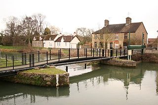
Stamford Canal, now disused, is one of the earliest post-Roman canals in England. It opened in 1670, around 100 years before the start of the Industrial Revolution which brought about the "golden age" for canals in Britain. Parts of the route can be traced on the ground, though only one lock survives intact. It was part of the Welland Navigation in Lincolnshire. First authorised in 1571, during the reign of Elizabeth I, construction did not start until 1664, under powers granted in 1620 and ratified by James I. It ran for 9.5 miles (15.3 km) from Stamford to Market Deeping and had 12 locks, two of which were on the river section at Deeping St James. No plans of its construction survive, although one of the locks was documented by a visiting water engineer in 1699. It contributed to the wealth of Stamford, allowing barley to be transported to the town for malting.
Edenham is a village and civil parish in the South Kesteven district of Lincolnshire, England. It is approximately 3 miles (5 km) north-west of Bourne, and on the A151 road. While the civil parish is called "Edenham", the parish council is called Edenham, Grimsthorpe, Elsthorpe & Scottlethorpe Parish Council. The population of the civil parish at the 2011 census was 291. The parish is principally located in the valley of the East Glen which flows through the village.

Tallington is a village and civil parish in the South Kesteven district of Lincolnshire, England. The population of the civil parish at the 2011 census was 497. It is situated 4 miles (6 km) east from Stamford and 8 miles (13 km) north-east from the centre of Peterborough. The village has around 200 houses.

The A6121 is a short cross-country road in the counties of Lincolnshire and Rutland, England. It forms the principal route between Bourne and Stamford and the A1 in Lincolnshire, continuing on through Ketton in Rutland to its junction with the A47 at Morcott. Its south-western end is at 52°35.5860′N0°38.0820′W and its north-eastern end is at 52°45.9120′N0°24.0660′W. The road has increased in importance with the rapid expansion of housing in this part of South Kesteven.

Wilsthorpe is a village in the district of South Kesteven in the county of Lincolnshire, England. It is situated approximately 6 miles (10 km) north-east from Stamford and approximately 4 miles (6 km) south from Bourne. The population is included in the civil parish of Braceborough and Wilsthorpe.

Duddington is a small village in Northamptonshire, England. It is by the junction of the A47 and A43 roads, and is 9 kilometres (6 mi) southwest of the town of Stamford. The village is on the east bank of the River Welland which is the county boundary of Rutland.

Stamford Museum was located in Stamford, Lincolnshire, in Great Britain. It was housed in a Victorian building in Broad Street, Stamford, and was run by the museum services of Lincolnshire County Council from 1980 to 2011.

The A1175 road is a public highway in south-west Lincolnshire, England within the United Kingdom.

Lolham is a hamlet in the City of Peterborough in England, located between Peterborough and Stamford on the border of Cambridgeshire and Lincolnshire. Lolham is located to the west of Maxey and to the south of West Deeping and is surrounded by the River Welland and Maxey Cut. There are eight residential properties in Lolham, which include Lolham Hall, a Grade II listed building. The main London-to-Edinburgh railway runs to the west of Lolham.


