Kingswood Junction

Last updated

Kingswood Junction
Kingswood Junction lock 20.jpg
Lock 20 (right), leading from the connecting arm to the Northern Stratford. To the left is the lockless arm leading to the bottom of lock 21.
Specifications
StatusOpen
Navigation authorityBritish Waterways
History
Date completed1803
Kingswood Junction
BSicon uCONTg.svg
BSicon CONTg.svg
BSicon uCONTg.svg
BSicon uSTR.svg
BSicon BHF.svg
BSicon uSTR.svg
Lapworth railway station
BSicon POINTERg@fq.svg
BSicon uSTR.svg
BSicon STR.svg
BSicon uSTR.svg
Northern Stratford Canal
BSicon uLOCKSu.svg
BSicon STR.svg
BSicon uSTR.svg
BSicon uSKRZ-Yu.svg
BSicon RYq.svg
BSicon SKRZ-Yo.svg
BSicon uSKRZ-Yu.svg
Old Warwick Road B4439
BSicon uddSTRr.svg
BSicon STR.svg
BSicon uSTR.svg
Reservoir in pound
BSicon uFGATEu.svg
BSicon STR.svg
BSicon uSTR.svg
Lock 19
BSicon uddSTRr.svg
BSicon STR.svg
BSicon uSTR.svg
Reservoir in pound
BSicon uABZgl.svg
BSicon uSTR+r.svg
BSicon STR.svg
BSicon uSTR.svg
BSicon uFGATEu.svg
BSicon uFGATEu.svg
BSicon STR.svg
BSicon uSTR.svg
Lock 21, Lock 20
BSicon uFABZgl+l.svg
BSicon uFABZqlr.svg
BSicon mKRZo.svg
BSicon uFABZgr+r.svg
BSicon uFGATEu.svg
BSicon STR.svg
BSicon uSTR.svg
Lock 22
BSicon POINTERg@fq.svg
BSicon uSTR.svg
BSicon STR.svg
BSicon uSTR.svg
Southern Stratford Canal
BSicon uSKRZ-Au.svg
BSicon RA+r.svg
BSicon STR.svg
BSicon POINTERg@fq.svg
BSicon uSTR.svg
Grand Union Canal
BSicon uSTR.svg
BSicon POINTERg@fq.svg
BSicon RA.svg
BSicon STR.svg
BSicon uSTR.svg
M40
BSicon uCONTf.svg
BSicon RACONTf.svg
BSicon CONTf.svg
BSicon uCONTf.svg

Kingswood Junction (grid reference SP185709 ) is a canal junction where the Stratford-upon-Avon Canal meets the Grand Union Canal at Kingswood, Warwickshire, England.

Contents

History

The Grand Union Canal was a late addition to the British canal system, being formed in 1929 by the amalgamation of a number of canal companies. This included the Warwick and Birmingham Canal, which was authorised in 1793 by an Act of Parliament, in the same year that the Grand Junction Canal from Braunston to Brentford was authorised. The Warwick and Napton Canal, authorised in 1794, provided a link from the southern end of the canal to the Oxford Canal at Napton Junction, from which it was a short distance to Braunston and the route to London. The two Warwick canals opened officially on 19 December 1799, but were probably unfinished, as no trade occurred until the following March. [1]

The Stratford-upon-Avon Canal was also authorised in 1793, as businessmen in the town wanted to ensure that the prosperity brought by the canals did not pass them by. The canal was to run from Kings Norton Junction, on the Worcester and Birmingham Canal, to Stratford, passing through Kingswood. The first part of the northern section to Hockley Heath was opened in 1796, but then the scheme foundered. It was not until 1800, when another Act of Parliament was obtained, that further progress was made, and the canal opened as far at Kingswood, and the junction with the Warwick and Birmingham Canal in 1803. There was then another delay, with construction of the southern route below Kingswood not starting until 1812. The canal finally reached Stratford in 1815. [2]

Although the junction was never officially closed, it was effectively closed in the 1940s. Parts of the southern section of the Stratford-upon-Avon Canal were dry, while there was little traffic on the northern section after 1939, which allowed the Great Western Railway to repair the Lifford swing bridge near Kings Norton Junction in 1942 in such a way that it could not be opened. The route from Kings Norton to Kingswood junctions was the scene of one of the first campaigns by the fledgling Inland Waterways Association, when Tom Rolt announced in 1947 that he intended to navigate along the canal. The railway company had to jack the bridge up, to allow his boat to pass, [3] and the event was widely reported in newspapers, gaining useful publicity. [4] The route from the junction to Stratford was reopened in 1964 by Queen Elizabeth The Queen Mother, having been taken over and restored by the National Trust. [5]

Location

The junction consists of a 250-metre linking arm with two branches at the (western) Stratford Canal end and a simple junction with the Grand Union at the eastern end. One of the branches descends through a lock to the connecting arm. The other branch is taken from the Stratford canal below another lock.

The Stratford Canal (the Northern Stratford Canal) heads, via a flight of locks, towards the Worcester and Birmingham Canal at Kings Norton Junction. South of Kingswood Junction the Southern Stratford Canal descends through locks to the River Avon at Stratford-upon-Avon. The Grand Union leads north to Knowle Locks, and then Birmingham, and leads south to Hatton Locks and Warwick.

See also

Bibliography

Related Research Articles

<span class="mw-page-title-main">Grand Union Canal</span> Canal in England

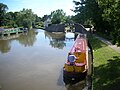
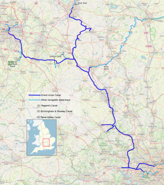
The Grand Union Canal in England is part of the British canal system. It is the principal navigable waterway between London and the Midlands. Starting in London, one arm runs to Leicester and another ends in Birmingham, with the latter stretching for 137 miles (220 km) with 166 locks from London. The Birmingham line has a number of short branches to places including Slough, Aylesbury, Wendover, and Northampton. The Leicester line has two short arms of its own, to Market Harborough and Welford.
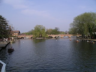
<span class="mw-page-title-main">River Avon, Warwickshire</span> River in central England

The River Avon in central England flows generally southwestwards and is a major left-bank tributary of the River Severn, of which it is the easternmost. It is also known as the Warwickshire Avon or Shakespeare's Avon, to distinguish it from several other rivers of the same name in the United Kingdom.

<span class="mw-page-title-main">Stratford-upon-Avon Canal</span>

The Stratford-upon-Avon Canal is a canal in the south Midlands of England. The canal, which was built between 1793 and 1816, runs for 25.5 miles (41.0 km) in total, and consists of two sections. The dividing line is at Kingswood Junction, which gives access to the Grand Union Canal. Following acquisition by a railway company in 1856, it gradually declined, the southern section being un-navigable by 1945, and the northern section little better.

<span class="mw-page-title-main">Oxford Canal</span> Canal in England

The Oxford Canal is a 78-mile (126 km) narrowboat canal in southern central England linking the City of Oxford with the Coventry Canal at Hawkesbury via Banbury and Rugby. Completed in 1790, it connects to the River Thames at Oxford, and links with the Grand Union Canal, which it is combined with for 5 miles (8 km) between to the villages of Braunston and Napton-on-the-Hill.

The Grand Junction Canal is a canal in England from Braunston in Northamptonshire to the River Thames at Brentford, with a number of branches. The mainline was built between 1793 and 1805, to improve the route from the Midlands to London, by-passing the upper reaches of the River Thames near Oxford, thus shortening the journey.

<span class="mw-page-title-main">Whilton Locks</span>

Whilton Locks is the name of a flight of seven locks on the Grand Union Canal near Daventry, in the county of Northamptonshire, England. They are also referred to as Buckby Lock Flight.

<span class="mw-page-title-main">Warwickshire ring</span>

The Warwickshire ring is a connected series of canals forming a circuit around the West Midlands area of England. The ring is formed from the Coventry Canal, the Oxford Canal, the Grand Union Canal, the Stratford-upon-Avon Canal and the Birmingham and Fazeley Canal. It is a popular route with tourists due to its circular route and mixture of urban and rural landscapes.

<span class="mw-page-title-main">Grand Union Canal (old)</span> Canal in England

The Grand Union Canal was a canal in England from Foxton, Leicestershire on the Leicestershire and Northamptonshire Union Canal to Norton Junction, close to Long Buckby Wharf on the Grand Junction Canal. It now forms the first 23 miles (37 km) of the Leicester line of the Grand Union Canal.

<span class="mw-page-title-main">Dudley Canal</span> Canal in the West Midlands, England

The Dudley Canal is a canal passing through Dudley in the West Midlands of England. The canal is part of the English and Welsh network of connected navigable inland waterways and forms part of the popular Stourport Ring narrowboat cruising route.

<span class="mw-page-title-main">Aldersley Junction</span> Canal junction

Aldersley Junction is the name of the canal junction where the Birmingham Main Line Canal terminates and meets the Staffordshire and Worcestershire Canal near to Oxley, north Wolverhampton, West Midlands, England. It opened in 1772.

<span class="mw-page-title-main">Aston Junction</span>

Aston Junction is the name of the canal junction where the Digbeth Branch Canal terminates and meets the Birmingham and Fazeley Canal near to Aston, Birmingham, England.

<span class="mw-page-title-main">Bordesley Junction</span> Canal junction in Bordesley, Birmingham, England

Bordesley Junction is a canal junction where the Grand Union Canal splits near to Bordesley, Birmingham, England. It opened in 1844, when the Birmingham and Warwick Junction Canal was built as part of a scheme to bypass the congestion at the Farmers Bridge flight of locks.

<span class="mw-page-title-main">Kings Norton Junction</span> Kings Norton Canal Junction

Kings Norton Junction is the name of the canal junction where the Stratford-upon-Avon Canal terminates and meets the Worcester and Birmingham Canal at Kings Norton, Birmingham, England.

<span class="mw-page-title-main">Rushall Junction</span> Canal junction

Rushall Junction is the southern limit of the Rushall Canal where it meets the Tame Valley Canal in the West Midlands, England. It opened in 1847, when the Rushall Canal was built to create connections between the Birmingham Canal Navigations system and the Wyrley and Essington Canal, following the amalgamation of the two companies in 1840.

<span class="mw-page-title-main">Tame Valley Junction</span> Canal junction

Tame Valley Junction, also known as Doe Bank Junction, is a canal junction at the western limit of the Tame Valley Canal where it meets the Walsall Canal, south of Walsall, in the West Midlands, England.

<span class="mw-page-title-main">Birchills Junction</span> Canal junction in the uk

Birchills Junction is the canal junction at the northern limit of what is now called the Walsall Canal where it meets the Wyrley and Essington Canal main line, near Walsall, West Midlands, England. It opened in 1798, but lasted for little more than a year, until it was re-opened in 1841 when a connecting link was built to the Birmingham Canal Navigations' southern route to Walsall.

<span class="mw-page-title-main">Birmingham and Liverpool Junction Canal</span>

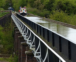
The Birmingham and Liverpool Junction Canal was a canal in England which ran from Nantwich, where it joined the Chester Canal, to Autherley, where it joined the Staffordshire and Worcestershire Canal. Forming part of a major link between Liverpool and the industrial heartlands of the Midlands, the canal was opened in 1835, and merged with the Ellesmere and Chester Canal Company in 1845, which became the Shropshire Union Railways and Canal Company in the following year.

<span class="mw-page-title-main">Avon Ring</span>

The Avon Ring is a canal ring which is located to the south west of Birmingham in England, and connects the major towns of Stratford-upon-Avon, Evesham, Tewkesbury, Worcester and the southern outskirts of Birmingham. It consists of stretches of four waterways, and is heavily locked, with a total of 129 locks on its route of 109 miles (175 km).

<span class="mw-page-title-main">Shrewley Tunnel</span>

Shrewley Tunnel is a canal tunnel near Shrewley, Warwickshire, England, which opened in 1799. It became part of the Grand Union Canal in 1929.

<span class="mw-page-title-main">Bascote Locks</span>

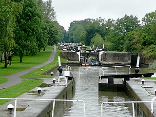
Bascote locks form a flight of four locks on the Grand Union Canal, which is part of the British canal system and connects London and Birmingham. The lock flight has a staircase, and at the highest lock the remains of older narrow locks can be seen.

References

  1. Hadfield 1970 , pp. 165–167, 170
  2. Nicholson 2003 , p. 137
  3. Ware 1989 , pp. 27–28
  4. Squires 2008 , p. 18
  5. Cumberlidge 2009 , p. 282

52°20′07″N1°43′39″W / 52.3352°N 1.7275°W / 52.3352; -1.7275