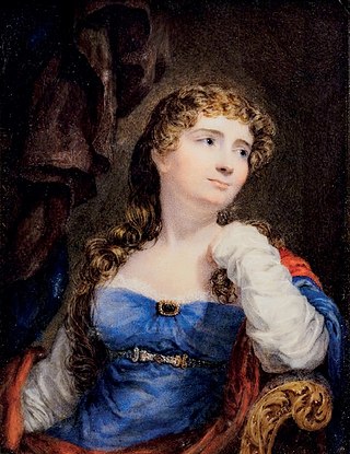
Anne Isabella Noel Byron, 11th Baroness Wentworth and Baroness Byron, nicknamed Annabella and commonly known as Lady Byron, was an educational reformer and philanthropist who established the first industrial school in England, and was an active abolitionist. She married the poet George Gordon Byron, more commonly known as Lord Byron, and separated from him after less than a year, keeping their daughter Ada Lovelace in her custody despite laws at the time giving fathers sole custody of children.

Willesley is a village and former civil parish, now in the parish of Ashby-de-la-Zouch, in the North West Leicestershire district, in the county of Leicestershire, England. It was originally in Derbyshire. Willesley Hall was the home of the Abney and later the Abney-Hastings family. In 1931 the parish had a population of 80.

Bag Enderby is a village and former civil parish, now in the parish of Greetham with Somersby, in the East Lindsey district of Lincolnshire, England. It lies just north of the A158 road, 6 miles (10 km) north-east from Horncastle and 4 miles (6 km) north-west from Partney. In 1931 the parish had a population of 29. On 1 April 1936 the parish was abolished and merged with Somersby.

Stapleton is a village and former civil parish, now in the parish of Kirkby Mallory, Peckleton and Stapleton, in the Hinckley and Bosworth district, in south-west Leicestershire, England, about ten miles south-west of Leicester city centre. Its population was 427 people at the 2001 census. In 1931 the parish had a population of 252. Stapleton was formerly a chapelry in Barwell parish, from 1866 Stapleton was a civil parish in its own right until it was abolished on 1 April 1935 and merged with Peckleton.

Peckleton is a small village and former civil parish, now in the parish of Kirkby Mallory, Peckleton and Stapleton, in the Hinckley and Bosworth district of Leicestershire, England. The villages of Kirkby Mallory and Stapleton also form part of the parish. Thus, according to the 2001 census, the parish had a population of 1,077, falling slightly to 1,067 at the 2011 census. Due east of the village is Peckleton Common, adjacent to The Glebe Fisheries, an angling centre of excellence completed in 1996. The local church, St Mary Magdalene, is located just south of the village centre.

Mallory Park is a motor racing circuit situated in the village of Kirkby Mallory, just off the A47, between Leicester and Hinckley, in central England. Originally used for grass-track until 1955, a new, basically oval hard-surfaced course was constructed for 1956, with a later extension forming a loop with a hairpin bend.

Baron Wentworth is a title in the Peerage of England. It was created in 1529 for Thomas Wentworth, who was also de jure sixth Baron le Despencer of the 1387 creation. The title was created by writ, which means that it can descend via female lines.

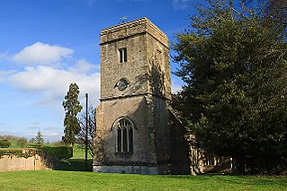
Sibson is a village and former civil parish, now in the parish of Sheepy, in the Hinckley and Bosworth district, in western Leicestershire, England, close to the border with North Warwickshire. It is situated approximately midway between the towns of Hinckley and Measham, and slightly northeast of Atherstone. In 1931 the parish had a population of 264.
Ogle is a village in and former civil parish, now in the parish of Whalton, Northumberland, England, north-west of Ponteland and south-west of Morpeth. The surname Ogle comes from here, where the Ogle family built Ogle Castle and owned Kirkley Hall. In 1951 the parish had a population of 122.
Thomas Noel, 2nd Viscount Wentworth was a British politician who succeeded to a peerage before he could take his seat in the House of Commons, having just been elected in 1774.

Teversal is a village in the Ashfield district of Nottinghamshire, England. It lies north of Sutton-in-Ashfield and 3 miles (5 km) west of Mansfield. It is close to the boundary with Derbyshire. Former names include Tevershalt, Teversholt, Tyversholtee, Teversale, Tevershall and Teversall.
Murston is a suburb of Sittingbourne, in the Swale district, in the county of Kent, England. It is about 1 mile north-east of central Sittingbourne, on the east bank of the Milton Creek.
Horndon on the Hill is a village, former civil parish and Church of England parish in the unitary authority of Thurrock, in the county of Essex, England. It is located close to the A13, around one mile northwest of Stanford-le-Hope and around two miles northeast of Orsett. The village area falls within the Orsett ward of Thurrock District Council. In 2019 it had an estimated population of 1517.

Croxall is a hamlet and former civil parish, now in the parish of Edingale, in the Lichfield district, in the county of Staffordshire, England. The settlement today is mainly the Church of England parish church of St John and Croxall Hall. On 30 September 1895 the part in Derbyshire was transferred to Staffordshire meaning Croxall was entirely in Staffordshire. In 1931 the parish had a population of 184.
Sir Clobery Noel, 5th Baronet, of Kirkby Mallory, Leicestershire, was an English Tory politician who sat in the House of Commons from 1727 to 1734.
Draycot Cerne (Draycott) is a small village and former civil parish, now in the parish of Sutton Benger, in Wiltshire, England, about 3 miles (5 km) north of Chippenham.

Culverthorpe is a hamlet in the civil parish of Culverthorpe and Kelby, in the North Kesteven district of Lincolnshire, England. It lies 5 miles (8 km) south-west from Sleaford, 9 miles (14 km) north-east from Grantham and 3 miles (5 km) south-east from Ancaster.

William Noel was an English barrister, judge and politician who sat in the House of Commons for 35 years from 1722 to 1757.
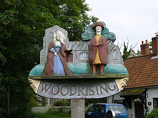
Woodrising is a village and former civil parish, now in the parish of Cranworth, in the Breckland district, in the county of Norfolk, England. The village of Woodrising is south of Dereham. In 1931 the parish had a population of 103.
Anne Lovelace, 7th Baroness Wentworth was an English peeress.

