Kirovsk (Russian : Кировск) is the name of several inhabited localities in Russia.
Russian is an East Slavic language, which is official in the Russian Federation, Belarus, Kazakhstan and Kyrgyzstan, as well as being widely used throughout Eastern Europe, the Baltic states, the Caucasus and Central Asia. It was the de facto language of the Soviet Union until its dissolution on 25 December 1991. Although nearly three decades have passed since the breakup of the Soviet Union, Russian is used in official capacity or in public life in all the post-Soviet nation-states, as well as in Israel and Mongolia.
The classification system of the types of inhabited localities in Russia, the former Soviet Union, and some other post-Soviet states has certain peculiarities compared with the classification systems in other countries.
Kirovsk is a town and the administrative center of Kirovsky District in Leningrad Oblast, Russia, located on the left bank of the Neva River, 33 kilometers (21 mi) east of St. Petersburg. Population: 25,650 (2010 Census); 24,361 (2002 Census); 23,655 (1989 Census).
Kirovsky District is an administrative and municipal district (raion), one of the seventeen in Leningrad Oblast, Russia. It is located in the center of the oblast and borders with Volkhovsky District in the east, Kirishsky District in the southeast, Nevsky and Kolpinsky Districts of the federal city of St. Petersburg in the west, Tosnensky District in the southwest, and with Vsevolozhsky District in the northwest. From the north, the district is bounded by Lake Ladoga. The area of the district is 2,590.46 square kilometers (1,000.18 sq mi). Its administrative center is the town of Kirovsk. Population : 62,533 (2010 Census); 60,221 ; 74,725 (1989 Census).
Leningrad Oblast is a federal subject of Russia. It was established on August 1, 1927, although it was not until 1946 that the oblast's borders had been mostly settled in their present position. The oblast was named after the city of Leningrad. Unlike the city, the oblast retains the name of Leningrad.
Kvarkensky District is an administrative and municipal district (raion), one of the thirty-five in Orenburg Oblast, Russia. The area of the district is 5,200 square kilometers (2,000 sq mi). Its administrative center is the rural locality of Kvarkeno. Population: 18,655 ; 23,525 (2002 Census); 23,890 (1989 Census). The population of Kvarkeno accounts for 21.0% of the district's total population.
Orenburg Oblast is a federal subject of Russia. Its administrative center is the city of Orenburg. From 1938 to 1957, it bore the name Chkalov Oblast in honor of Valery Chkalov. Population: 2,033,072.
This article includes a list of related items that share the same name (or similar names). If an internal link incorrectly led you here, you may wish to change the link to point directly to the intended article. |
Apatity is a town in Murmansk Oblast, Russia, located along the Murman Railway between Lake Imandra and the Khibiny Mountains, 23 km (14 mi) west of Kirovsk and 185 km (115 mi) south of Murmansk, the administrative center of the oblast. The town is named after one of its most abundant natural resources in the area, apatite, the raw mineral used in the production of phosphorus mineral fertilizers. Population: 59,672 (2010 Census).
Monchegorsk is a town in Murmansk Oblast, Russia, located on the Kola Peninsula, 145 kilometers (90 mi) south of Murmansk, the administrative center of the oblast. Population: 45,361 (2010 Census); 52,242 ; 68,652.
Sinyavino is an urban locality in Kirovsky District of Leningrad Oblast, Russia, located several kilometers inland from the southern shore of Lake Ladoga, 58 kilometers (36 mi) east of St. Petersburg and 8 kilometers (5.0 mi) east from Kirovsk. Municipally it is incorporated as Sinyavinskoye Urban Settlement, one of the eight urban settlements in the district. Population: 3,784 (2010 Census); 3,611 (2002 Census); 1,949 (1989 Census).
Mga is an urban locality in Kirovsky District of Leningrad Oblast, Russia. Population: 10,212 (2010 Census); 9,613 (2002 Census); 9,852 (1989 Census).
Murmansk Oblast is a federal subject of Russia, which is located in the northwestern part of the country, occupying mostly the Kola Peninsula. The oblast itself was established on May 28, 1938, but some kind of administrative organization of the territory existed here since at least the 13th century. As of the 2002 Census, Russians account for the majority of the oblast's population, with the indigenous Sami constituting only a 0.20% minority (1,769 people).
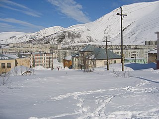
Kirovsk, known as Khibinogorsk (Хибиного́рск) until 1934, is a town in Murmansk Oblast, Russia, located at the spurs of the Khibiny Mountains on the shores of the Lake Bolshoy Vudyavr, 175 kilometers (109 mi) south of Murmansk. Population: 28,625 (2010 Census).
Imeni Kirova is the name of several rural localities in Russia:
Kolsky District is an administrative district (raion), one of the six in Murmansk Oblast, Russia. As a municipal division, it is incorporated as Kolsky Municipal District. It is located in the northwest of the oblast, partially lies on the Kola Peninsula, and borders with the Barents Sea in the north and Finland in the west. The area of the district is 27,600 square kilometers (10,700 sq mi). Its administrative center is the town of Kola. Population: 44,670 (2010 Census); 51,125 (2002 Census); 73,555 (1989 Census). The population of Kola accounts for 23.4% of the district's total population.
Slavyanka is the name of several inhabited localities in Russia.
Murmansk Okrug was an administrative division of the Russian SFSR, Soviet Union, which existed in 1927–1938.
Monchegorsky District was an administrative division of Murmansk Okrug of Leningrad Oblast, and later of Murmansk Oblast of the Russian SFSR, Soviet Union, which existed in 1938–1949.
Kirovsky District was an administrative division of Murmansk Okrug of Leningrad Oblast, and later a district of Murmansk Oblast, of the Russian SFSR, Soviet Union, which existed in 1935–1954.
Uralsky, Uralskaya, or Uralskoye is the name of several inhabited localities in Russia.
Ruchyi is the name of several rural localities in Russia.
Priladozhsky is an urban locality in Kirovsky District of Leningrad Oblast, Russia, located 3 kilometres (1.9 mi) from the southern shore of Lake Ladoga, on the left bank of the Naziya River, 10 kilometres (6.2 mi) east of the town of Kirovsk. Municipally, together with the village of Naziya, it is incorporated as Priladozhskoye Urban Settlement, one of the eight urban settlements in the district. Population: 5,757 (2010 Census); 5,185 (2002 Census); 5,280 (1989 Census).
Naziya is an urban locality in Kirovsky District of Leningrad Oblast, Russia, located on the left bank of the Lava River and on the right bank of the Kovra River, east of the town of Kirovsk. Municipally it is incorporated as Naziyevskoye Urban Settlement, one of the eight urban settlements in the district. Population: 4,858 (2010 Census); 5,755 (2002 Census); 7,712 (1989 Census).
Otradnoye is a town in Kirovsky District of Leningrad Oblast, Russia, located 40 kilometers (25 mi) east of St. Petersburg on the left bank of the Neva River, at its confluence with the Tosna River. Population: 23,866 (2010 Census); 21,570 (2002 Census); 22,386 (1989 Census).