
Ground transport in the Democratic Republic of Congo (DRC) has always been difficult. The terrain and climate of the Congo Basin present serious barriers to road and rail construction, and the distances are enormous across this vast country. Furthermore, chronic economic mismanagement and internal conflict has led to serious under-investment over many years.

The Great Rift Valley is a series of contiguous geographic trenches, approximately 6,000 kilometres (3,700 mi) in total length, that runs from the Beqaa Valley in Lebanon in Asia to Mozambique in Southeast Africa. While the name continues in some usages, it is rarely used in geology as it is considered an imprecise merging of separate though related rift and fault systems.

Tanzania comprises many lakes, national parks, and Africa's highest point, Mount Kilimanjaro. Northeast Tanzania is mountainous, while the central area is part of a large plateau covered in grasslands. The country also contains the southern portion of Lake Victoria on its northern border with Uganda and Kenya.
Transport in Tanzania includes road, rail, air and maritime networks. The road network is 86,472 kilometres (53,731 mi) long, of which 12,786 kilometres (7,945 mi) is classified as trunk road and 21,105 kilometres (13,114 mi) as regional road. The rail network consists of 3,682 kilometres (2,288 mi) of track. Commuter rail service is in Dar es Salaam only. There are 28 airports, with Julius Nyerere International being the largest and the busiest. Ferries connect Mainland Tanzania with the islands of Zanzibar. Several other ferries are active on the countries' rivers and lakes.
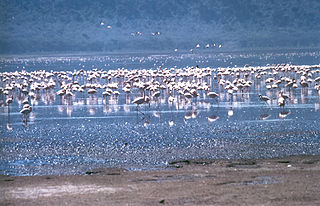
The Rift Valley lakes are a series of lakes in the East African Rift valley that runs through eastern Africa from Ethiopia in the north to Malawi in the south, and includes the African Great Lakes in the south. These include some of the world's oldest lakes, deepest lakes, largest lakes by area, and largest lakes by volume. Many are freshwater ecoregions of great biodiversity, while others are alkaline "soda lakes" supporting highly specialised organisms.
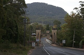
The Kangaroo River is a perennial river of the Shoalhaven catchment located in the Southern Highlands and Illawarra regions of New South Wales, Australia.

The Sibley Peninsula is a 52 kilometres (32 mi) long and 10 kilometres (6 mi) wide peninsula in Ontario, Canada, on Lake Superior. It projects into the lake from Superior's north shore, and separates Thunder Bay to the west from Black Bay to the east.

Kalemie, formerly Albertville or Albertstad, is a town on the western shore of Lake Tanganyika in the Democratic Republic of the Congo. The town is next to the outflow of the Lukuga River from Lake Tanganyika to the Lualaba River.

Moba is a town located in the Democratic Republic of the Congo in Tanganyika Province. It is the administrative center of Moba Territory.

Limingen (Norwegian) or Lyjmede (Southern Sami) is a lake in the municipalities of Røyrvik and Lierne in Trøndelag county, Norway. It is the eighth-largest lake in the country. The lake lies 418 metres (1,371 ft) above sea level and has an area of 94 square kilometres (36 sq mi). At the deepest point, it is 192 metres (630 ft) deep and averages about 87 metres (285 ft) deep. The lake has a volume of 8.34 cubic kilometres (2.00 cu mi) and is located just north of the large lake Tunnsjøen. The border with Sweden lies about 725 metres (0.5 mi) east of the lake.

The Albertine Rift is the western branch of the East African Rift, covering parts of Uganda, the Democratic Republic of the Congo (DRC), Rwanda, Burundi and Tanzania. It extends from the northern end of Lake Albert to the southern end of Lake Tanganyika. The geographical term includes the valley and the surrounding mountains.
Rail transport in the Democratic Republic of the Congo is provided by the National Railway Company of the Congo, the ONATRA and the Office of the Uele Railways.
Moba Territory is a territory in the Tanganyika Province of the Democratic Republic of the Congo. The administrative center is Moba port. The territory has an estimated area of 24,500 square kilometres (9,500 sq mi) and a population of almost 610,000.
The Marungu highlands are in the Katanga Province of the Democratic Republic of the Congo, to the west of the southern half of Lake Tanganyika.
The Mulobozi River is a stream in Tanganyika Province of the southeastern Democratic Republic of the Congo.

Kokunye Kyun is an island in the Andaman Sea, right off the coast of Mon State, in the southern area of Burma. It is located in an area of shoals. This island is 1.4 kilometres (0.87 mi) long and its maximum width is 0.4 kilometres (0.25 mi). It is covered with dense forest and rises to a height of 140 metres (460 ft).
The Lufuko River is a river in the Democratic Republic of the Congo that empties into Lake Tanganyika beside the village of Mpala in Tanganyika Province.
The Muganja hills are a range in the Tanganyika District of Katanga Province in the Democratic Republic of the Congo, to the south of Kalemie.

Chandesi, also Chandeshi or Chambeshi, is a town in the Northern Province of Zambia.
McKenzie Lake is a lake in South Algonquin, Nipissing District and Hastings Highlands, Hastings County in Ontario, Canada, about 14 kilometres (9 mi) south of the community of Madawaska, and a similar distance north of the small town of Maynooth. The settlement of McKenzie Lake is on the north shore of the lake.
