Related Research Articles

Kagera is an administrative region of Tanzania that is located on the western shore of Lake Victoria in the north-west of the country. Kagera borders Uganda, Rwanda, Burundi and Kenya, which is on the other side of Lake Victoria. The regional capital city is Bukoba.

Ruaha National Park is a national park in Tanzania. The addition of the Usangu Game Reserve and other important wetlands to the park in 2008 increased its size to about 20,226 km2 (7,809 sq mi).

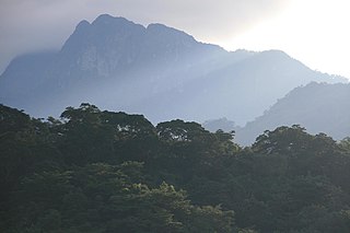
Kilimanjaro National Park is a Tanzanian national park, located 300 kilometres (190 mi) south of the equator and in Kilimanjaro Region, Tanzania. The park is located near the region of Moshi. The park includes the whole of Mount Kilimanjaro above the tree line and the surrounding montane forest belt above 1,820 metres (5,970 ft). It covers an area of 1,688 square kilometres (652 sq mi), 2°50'–3°10'S latitude, 37°10'–37°40'E longitude. The park is administered by the Tanzania National Parks Authority (TANAPA). It was established as a national park in 1973.

Muleba is one of the six districts of the Kagera Region of Tanzania. It is bordered to the north by the Bukoba Urban and Bukoba Rural districts, to the south by the Biharamulo District, to the east by Lake Victoria and to the west by the Ngara and Karagwe districts. The district covers and area of 3,518 square kilometres (1,358 sq mi).

Biharamulo District is one of the eight districts of the Kagera Region of Tanzania. It is bordered to the north by Karagwe District and Muleba District, to the east and south by Geita Region, to the west by Ngara District, and to the southwest by the Kigoma Region. Its administrative seat is Biharamulo town. Biharamulo Game Reserve is located within the borders of the district.
Karagwe is one of the eight districts of the Kagera Region of Tanzania. It is bordered to the north by Uganda, to the east by the Bukoba Rural District, to the southeast by the Muleba District, to the south by the Ngara District and to the west by Republic of Rwanda, from which it is divided by the River Kagera. Small lakes such as the Ikimba, Burigi, Rushwa, and Rwakajunju provide fishing opportunities for residents of the Karagwe District. The district covers and area of 5,134 square kilometres (1,982 sq mi).
The Udzungwa Mountains are a mountain range in south-central Tanzania. The mountains are mostly within Iringa Region, south of Tanzania's capital Dodoma. The Udzungwa Mountains are part of the Eastern Arc Mountains, and are home to a biodiverse community of flora and fauna with large numbers of endemic species.

Saadani National Park is Tanzania's 13th national park and has an area of 1,062 km2 (410 sq mi). It was officially gazetted in 2005 and is managed under the Tanzania National Parks Authority. The park is located administratively in southeast Pangani District of Tanga Region and northeast Chalinze District of Pwani Region.

Tanzania is a country with many tourist attractions. Approximately 38 percent of Tanzania's land area is set aside in protected areas for conservation. There are 17 national parks, 29 game reserves, 40 controlled conservation areas and marine parks. Tanzania is also home to Mount Kilimanjaro, the highest point in Africa.
Mikumi National Park is a national park near Morogoro, Tanzania with an area of 3,230 km2 (1,250 sq mi) that was established in 1964. It is the fourth largest in the country. The park is crossed by Tanzania's A-7 highway.

Rubondo Island National Park is one of two Tanzanian national parks located on an island in Lake Victoria. The Island is administered by Geita District of Geita Region, and as a National Park, the island is under TANAPA. The island attracts a small number of visitors each year, mainly game fishermen and bird enthusiasts.

(TANAPA))
The Tanzania National Parks Authority commonly known as TANAPA is responsible for the management of Tanzania's national parks. TANAPA is a parastatal corporation and all its income is reinvested into the organization. It is governed by a number of instruments including the National Parks Act, Chapter 282 of the 2002 and the Wildlife Conservation Act No. 5 of 2009. TANAPA manages the nation's 22 National parks which covers approximately 15% of the land area and has the mandate to conserve and manage the wildlife in Tanzania, and to enforce the related laws and regulations in this industry. It manages the biodiversity of the country, protecting and conserving the flora and fauna. The organization does not have a mandate over the game reserves such as the Selous Game Reserve which is managed by the Tanzanian Wildlife Division and the Ngorongoro Conservation Area managed by the Ngorongoro Conservation Authority.

Saanane Island National Park is a Tanzanian national park in Mwanza. The park is located on an island in Lake Victoria and can be reached by boat from the TANAPA offices on Capri Point in Mwanza town. It is named after the local farmer and fisherman Mzee Saanane Chavandi.

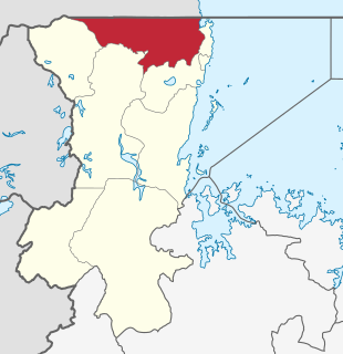
Kyerwa District is one of the eight districts of the Kagera Region of Tanzania. It is one of the 20 new districts that were formed in Tanzania since 2010; it was split off from Karagwe District. It is bordered to the north by Uganda, to the east by Missenyi District, to the south by Karagwe District and to the west by Rwanda, and has an area of 2,575 square kilometres (994 sq mi).
Missenyi District is one of the eight districts of the Kagera Region of Tanzania. The district was created in 2007, separating from Bukoba District. It is bordered to the north by Uganda, to the east by Bukoba Rural District, to the south by Karagwe District and to the west by Kyerwa District.

Innocent Lugha Bashungwa is Minister of State in the President’s Office in Tanzania. He previously served as Minister of Information, Culture, Arts and Sports and is a member of the Chama Cha Mapinduzi political party. He was elected MP representing Karagwe in 2015.

Nyerere National Park is the largest national park in Tanzania and also one of the world's largest wildlife sanctuaries and national parks. The total area of the park is 30,893 km2 (11,928 sq mi) and covers the big part of Liwale District in western Lindi Region, south west Pwani Region, north eastern Ruvuma Region and a big part of south eastern Morogoro Region. The area is larger than 70 countries in the world and is estimated to be twice the size of Costa Rica and about twice the size of Belgium (Europe). Much of the area is in a wild state without being altered by human activities. The part of Selous game reserve is now running a hydro electric power. The park has a great river known as Rufiji River. Rufiji is Tanzania's largest river and is home to many crocodiles and hippopotamuses. It is also one of largest mangrove forests in the world located at its delta.
References
- ↑ "Rumanyika-Karagwe National Park" (PDF). Tanzania National Parks (TANAPA). Dodoma, Tanzania: Tanzania National Parks (TANAPA). 2019. Archived (PDF) from the original on 20 June 2022. Retrieved 14 July 2022.
| | This Tanzania location article is a stub. You can help Wikipedia by expanding it. |