Kjenner

Last updated

Kjenner is a village in Lier municipality in Buskerud, Norway.

Lier, Norway Municipality in Buskerud, Norway

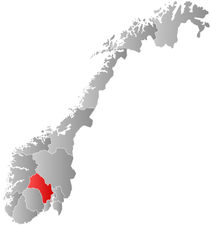
Lier is a municipality in Buskerud county, Norway. The administrative centre of the municipality is the village of Lierbyen. The municipality of Lier was established on 1 January 1838. The area Åssiden was transferred from Lier to the neighboring municipality of Drammen on 1 July 1951.

Buskerud County (fylke) of Norway

Buskerud is a county in Norway, bordering Akershus, Oslo, Oppland, Sogn og Fjordane, Hordaland, Telemark and Vestfold. The county extends from the Oslofjord and Drammensfjorden in the southeast to Hardangervidda mountain range in the northwest. The county administration is located in Drammen. Together with Akershus and Østfold, Buskerud will form the new, larger county Viken, from 1 January 2020.

Norway constitutional monarchy in Northern Europe

Norway, officially the Kingdom of Norway, is a Nordic country in Northern Europe whose territory comprises the western and northernmost portion of the Scandinavian Peninsula; the remote island of Jan Mayen and the archipelago of Svalbard are also part of the Kingdom of Norway. The Antarctic Peter I Island and the sub-Antarctic Bouvet Island are dependent territories and thus not considered part of the kingdom. Norway also lays claim to a section of Antarctica known as Queen Maud Land.

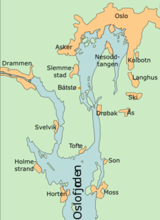
Kjenner located near Tranby and close to the European route E18, near from the border between Buskerud and Akershus. It is situated about eight kilometers west of the center of Asker and nine kilometers to the southwest of the community center of Lierbyen. The village had 1,954 inhabitants as of 1 January 2012. [1]

Tranby Place

Tranby is a village in Lier municipality in Buskerud, Norway. Tranby is located approximately 25 minutes drive southwest of Oslo and 10 minutes drive north of Drammen.

European route E18 road in Europe

European route E18 runs from Craigavon in Northern Ireland to Saint Petersburg in Russia, passing through Scotland, Norway, Sweden, and Finland. It is about 1,890 kilometres in length.

Akershus County (fylke) of Norway

Akershus[²ɑːkəʂˌhʉːs](listen) is a county in Norway, bordering Hedmark, Oppland, Buskerud, Oslo, and Østfold; it also has a short border with Sweden (Värmland). Akershus, with a little over 614,000 inhabitants, is the second most populated county by population after Oslo. The county is named after Akershus Fortress. The county administration is in Oslo, which is not part of the county per se.

Related Research Articles

Hønefoss Unincorporated city in Buskerud, Norway

Hønefoss is a town and the administrative center of the municipality of Ringerike in Buskerud county, Norway. Hønefoss is an industrial center of inner Østlandet, containing several factories and other industry. As of 1 January 2008, Hønefoss has 14,177 inhabitants. In 1852, Hønefoss received town status and was separated from Norderhov. In 1964, Hønefoss ceased being a separate municipality and became part of Ringerike.

Greater Oslo Region is a statistical metropolitan region surrounding the Norwegian capital of Oslo. The region includes the city of Oslo, the entire county of Akershus and several municipalities in the counties of Buskerud (150,709), Oppland (8,552), Vestfold (27,695) and Østfold (102,808).

Solbergelva

Solbergelva is a village in Nedre Eiker in the county of Buskerud, Norway. Solbergelva is a suburb of Drammen, Norway.

Sætre, Buskerud urban area in Norway

Sætre is a village in Buskerud county, Norway. It is the administrative centre of the municipality of Hurum.

Svene

Svene is a village in the municipality of Flesberg in Buskerud, Norway. It is located in Numedal, 10 kilometres from Kongsberg. Its population (2017) is 376.

Skoger quarter in Drammen, Norway

Skoger is a village located on the border between Buskerud and Vestfold counties, Norway. Of its population of 1,082 as of 2005, 654 were registered as residents of Drammen whereas 428 live in Sande in Vestfold county, Norway.

Helgelandsmoen

Helgelandsmoen is a village located in Buskerud, Norway.

Kroksund

Kroksund is a small village in the municipality of Hole, in Buskerud, Norway.

Lierskogen

Lierskogen is the easternmost village of Lier municipality in Buskerud county, Norway. Situated in the south-east corner of Buskerud, it makes up the eastern part of Lier together with the nearby village of Tranby. It borders Asker and Akershus to the east. Norway's busiest motorway, European route E18 which runs between Oslo – Drammen, goes straight through Lierskogen.

Burud is a village in Øvre Eiker municipality in Buskerud, Norway. Burud is located on the western bank of Drammenselva, 75 kilometers from Oslo. It had a train station which dated to 1875 on the Randsfjordbanen between Hokksund and Skotselv. This building was demolished in 1988. The station was downgraded to stop downloading tracks with passenger traffic closed down in 2001.

Oddevall is a village in Lier municipality, county of Buskerud, Norway. Oddevall and the neighboring village of Sjåstad are regarded as a single community with a combined population of 556 residents as of 1 January 2014.

Båtstø

Båtstø is a small village in Buskerud, Norway.

Hyggen

Hyggen is a small village in Røyken municipality, Buskerud county, Norway.

Kvisla is a village in Hol municipality in Buskerud, Norway.

Bødalen, Buskerud human settlement

Bødalen is a village in Røyken municipality of Buskerud, Norway. Bødalen is located on the Oslofjord, west of Oslo, Norway.

Mjøndalen Place

Mjøndalen is the administrative centre of Nedre Eiker municipality in Buskerud county, Norway. It is situated south of the Drammenselva River opposite of Krokstadelva.

Sollihøgda

Sollihøgda is a village in Hole municipality, in the county of Buskerud, Norway. It is situated near the border with the municipality of Bærum, in the county of Akershus, 28 km from Oslo.

Lierbyen

Lierbyen is the administrative center of Lier municipality in Buskerud county, Norway. The village is situated on the Lierelva River in the valley of Lierdalen which extends from Drammensfjord north toward Sylling near Tyrifjorden. Lierbyen is located about 39 km from Oslo, about 8 km from Drammen off European route E18. Lierbyen is a part of a greater urban area which also encompasses the villages Lier, Reistad and Kjellstad. The urban area has a population of 4,233 (2007)..

Buskerud County Municipality County in Norway

Buskerud County Municipality is the regional governing administration of Buskerud, Norway. The main responsibilities of the county municipality includes the running of the upper secondary schools. It administrates county roadways, public transport, dental care, culture and cultural heritage.

References

Coordinates: 59°48′40″N10°18′47″E / 59.81111°N 10.31306°E / 59.81111; 10.31306

Geographic coordinate system Coordinate system

A geographic coordinate system is a coordinate system that enables every location on Earth to be specified by a set of numbers, letters or symbols. The coordinates are often chosen such that one of the numbers represents a vertical position and two or three of the numbers represent a horizontal position; alternatively, a geographic position may be expressed in a combined three-dimensional Cartesian vector. A common choice of coordinates is latitude, longitude and elevation. To specify a location on a plane requires a map projection.