
Dobrich is the 9th most populated city in Bulgaria, the administrative centre of Dobrich Province and the capital of the region of Southern Dobrudzha. It is located in the northeastern part of the country, 30 km west of the Bulgarian Black Sea Coast, not far from resorts such as Albena, Balchik, and Golden Sands. In January 2012, Dobrich was inhabited by 79,269 people within the city limits. The city is named after the Bulgarian medieval lord of the surrounding region - Dobrotitsa. Agriculture is the most developed branch of the economy. The most popular types of agricultural products in the region are wheat and lavender oil.

The provinces of Bulgaria are the first-level administrative subdivisions of the country.
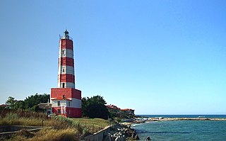
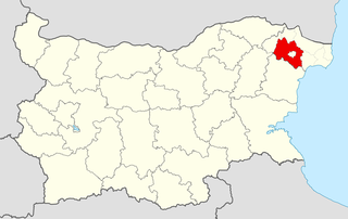
Dobrich Province is a province in northeastern Bulgaria, part of Southern Dobruja geographical region. It is bounded on the east by the Black Sea, on the south by Varna Province, on the west by Shumen and Silistra provinces, and on the north by Romania. It is divided into eight municipalities. At the 2011 census, it had a population of 186,016. The province was part of Romania between 1913 and 1940.
General Toshevo is a town in northeastern Bulgaria, part of Dobrich Province. Located in the historic region of Southern Dobruja, it is the administrative centre of the homonymous municipality and was named after the noted Bulgarian General Stefan Toshev. As of December 2009, the town had a population of 7,130.

Severoiztochen Planning Region is a planning region in Bulgaria.The region includes four provinces: Targovishte Province, Varna Province, Shumen Province and Dobrich Province.
Dobrichka municipality or Dobrich rural municipality (Добрич-селска) is a municipality in Dobrich Province, Northeastern Bulgaria, located in Southern Dobruja geographical region. It lies in the central southern part of the province and is not to be confused with Dobrich municipality, which is an enclave within Dobrichka.
Tervel is a town in northeastern Bulgaria, part of Dobrich Province. It is the administrative centre of Tervel Municipality, which lies in the westernmost part of the province. As of December 2009, the town had a population of 6,667.

8th Multi-member Constituency – Dobrich is a constituency whose borders are the same as Dobrich Province in Bulgaria.
Batovo is a village in the municipality of Dobrichka, in Dobrich Province, in northeastern Bulgaria.
Cherna, Dobrich Province is a village in the municipality of Dobrichka, in Dobrich Province, in northeastern Bulgaria.
Dobrevo is a village in the municipality of Dobrichka, in Dobrich Province, in northeastern Bulgaria.
Ovcharovo is a village in the municipality of Dobrichka, in Dobrich Province, in northeastern Bulgaria.
Krapets is a coastal village in Shabla Municipality, Dobrich Province, northeastern Bulgaria.
Bezmer, Dobrich Province is a village in Tervel Municipality, Dobrich Province, northeastern Bulgaria.
Brestnitsa, Dobrich Province is a village in Tervel Municipality, Dobrich Province, in northeastern Bulgaria.
Gradnitsa, Dobrich Province is a village in Tervel Municipality, Dobrich Province, in northeastern Bulgaria.
Orlyak, Dobrich Province is a village in Tervel Municipality, Dobrich Province, in northeastern Bulgaria.

Dobrich, Haskovo Province is a village in the municipality of Dimitrovgrad, in Haskovo Province, in southern Bulgaria. It is located 7 kilometers east of Dimitrovgrad. The mayor of the village is Marin Marinov.

General Toshevo Municipality is a municipality (obshtina) in Dobrich Province, Northeastern Bulgaria, located in Southern Dobruja geographical region, bounded by Romania to the north. It is named after its administrative centre - the town of General Toshevo.
