Kleč, Semič

Last updated
Kleč
Klec Semic Slovenia.jpg
Slovenia location map.svg
Red pog.svg
Kleč
Location in Slovenia
Coordinates: 45°38′0.60″N15°7′44.76″E / 45.6335000°N 15.1291000°E / 45.6335000; 15.1291000 Coordinates: 45°38′0.60″N15°7′44.76″E / 45.6335000°N 15.1291000°E / 45.6335000; 15.1291000
Country Flag of Slovenia.svg Slovenia
Traditional region Lower Carniola
Statistical region Southeast Slovenia
Municipality Semič
Elevation 635.7 m (2,085.6 ft)
Population (2002)
  Total none

Kleč (pronounced  [ˈkleːtʃ] ; in older sources also Kleče, [1] German : Kletsch, [2] [3] also Kletsch bei Stockendorf [1] ) is a remote former settlement in the Municipality of Semič in southern Slovenia. The area is part of the traditional region of Lower Carniola and is now included in the Southeast Slovenia Statistical Region. [4] Its territory is now part of the village of Planina. [5]

German language West Germanic language

German is a West Germanic language that is mainly spoken in Central Europe. It is the most widely spoken and official or co-official language in Germany, Austria, Switzerland, South Tyrol (Italy), the German-speaking Community of Belgium, and Liechtenstein. It is also one of the three official languages of Luxembourg and a co-official language in the Opole Voivodeship in Poland. The languages which are most similar to German are the other members of the West Germanic language branch: Afrikaans, Dutch, English, the Frisian languages, Low German/Low Saxon, Luxembourgish, and Yiddish. There are also strong similarities in vocabulary with Danish, Norwegian and Swedish, although those belong to the North Germanic group. German is the second most widely spoken Germanic language, after English.

Municipality of Semič Municipality in Slovenia

The Municipality of Semič is a municipality in Slovenia in the traditional region of White Carniola in southeastern Slovenia. The municipality is included in the Southeast Slovenia Statistical Region. Its seat is the settlement Semič.

Slovenia republic in Central Europe

Slovenia, officially the Republic of Slovenia, is a sovereign state located in southern Central Europe at a crossroads of important European cultural and trade routes. It is bordered by Italy to the west, Austria to the north, Hungary to the northeast, Croatia to the southeast, and the Adriatic Sea to the southwest. It covers 20,273 square kilometers (7,827 sq mi) and has a population of 2.07 million. One of the successor states of the former Yugoslavia, Slovenia is a parliamentary republic and a member of the United Nations, of the European Union, and of NATO. The capital and largest city is Ljubljana.

Contents

Name

The origin of the name Kleč is uncertain. Snoj observes that settlements named Kleč(e) generally lie along rivers and he connects this with the Slovene common noun kleč 'sandy or gravely river bank; gravely area covered with thin soil', referring to the local geology. Bezlaj also mentions the possibility of derivation from *klękъ 'small branching hills'. [6] Another possibility is that it is derived from kleč with the meaning 'cliff'. [7] Petschauer suggests that the name is derived from klet with the meaning 'shed, shack'. [8]

History

Kleč was a Gottschee German village. It was one of the more recent Gottschee settlements, founded after 1558 in a group of about 25 new settlements. [9] :17 In the land registry of 1574 the settlement had two full farms divided into four half-farms plus an additional eighth-farm, corresponding to a population between 25 and 30. In 1770 there were 11 houses in the settlement. Its population peaked at 53 in 1890, followed by a decline due to large-scale emigration to the United States. [9] :17 In 1931 the village included six houses and a population of 29. [9] :253 Before the Second World War, the economy of the village was based on raising animals, growing grapes, and selling wooden ware, logs, and firewood. [10] The original residents were evicted on 25 November 1941. [9] :18 Italian troops burned the village during the Rog Offensive on 26 August 1942 and it was not rebuilt after the war. [5] [9] :18 [11] There was a Partisan camp for some time in the forest below Kleč. A Partisan field hospital operated here in the fall of 1943. [11] A hunter's house was built at the site in the 1950s. [9] :18 The entire former village site is registered as cultural heritage. [5]

Gottscheers ethnic group

Gottscheers are the German settlers of the Kočevje region of Slovenia, formerly Gottschee County. Until the Second World War, their main language of communication was Gottscheerish, a Bavarian dialect.

Yugoslav Partisans Yugoslavian resistance movement

The Yugoslav Partisans, or the National Liberation Army, officially the National Liberation Army and Partisan Detachments of Yugoslavia, was the Communist-led resistance to the Axis powers in occupied Yugoslavia during World War II.

Church

Remains of Saint Anthony the Great Church Klec Semic Slovenia - church 1.jpg
Remains of Saint Anthony the Great Church

A chapel of ease dedicated to Saint Anthony the Great stood southwest of the village. It dated to the end of the 17th century. [10] A 1741 visitation record reported that it was dedicated to Saint Anthony of Padua. [9] :18 The church was destroyed after the Second World War. Two of its bells were sold to the church in Jugorje pri Metliki and a smaller bell was stolen. The clock was taken to Štrekljevec. The furnishings of the church were looted, and its building stones were crushed and used to repair the roads. Visible remnants of the church include part of the wall from the altar area and the floor, some remnants of cast-iron grave markers, and a small statue of a saint preserved in a niche. [9] :19

Chapel of ease

A chapel of ease is a church building other than the parish church, built within the bounds of a parish for the attendance of those who cannot reach the parish church conveniently.

Anthony the Great Christian saint, monk, and hermit

Saint Anthony or Antony, was a Christian monk from Egypt, revered since his death as a saint. He is distinguished from other saints named Anthony such as Anthony of Padua, by various epithets of his own: Anthony the Great, Anthony of Egypt, Antony the Abbot,Anthony of the Desert,Anthony the Anchorite, and Anthony of Thebes. For his importance among the Desert Fathers and to all later Christian monasticism, he is also known as the Father of All Monks. His feast day is celebrated on 17 January among the Orthodox and Roman Catholic churches and on Tobi 22 in the Coptic calendar used by the Coptic Church.

Anthony of Padua Franciscan

Saint Anthony of Padua, born Fernando Martins de Bulhões - also known as Saint Anthony of Lisbon - was a Portuguese Catholic priest and friar of the Franciscan Order. He was born and raised by a wealthy family in Lisbon, Portugal, and died in Padua, Italy. Noted by his contemporaries for his powerful preaching, expert knowledge of scripture, and undying love and devotion to the poor and the sick, he was one of the most quickly canonized saints in church history. He was proclaimed a Doctor of the Church on 16 January 1946. He is also the patron saint of lost things.

Related Research Articles

Travni Dol Place in Lower Carniola, Slovenia

Travni Dol is a small settlement in the hills south of Novo Mesto in southeastern Slovenia. The area is part of the traditional region of Lower Carniola and is now included in the Southeast Slovenia Statistical Region.

Bistrica, Črnomelj Place in White Carniola, Slovenia

Bistrica is a small settlement in the hills west of Črnomelj in the White Carniola area of southeastern Slovenia. The area is part of the traditional region of Lower Carniola and is now included in the Southeast Slovenia Statistical Region. It is located on a rocky terrace with sinkholes along the road from Črnomelj to the Poljane Valley.

Koblarji Place in Lower Carniola, Slovenia

Koblarji is a settlement northwest of Kočevje in southern Slovenia. The area is part of the traditional region of Lower Carniola and is now included in the Southeast Slovenia Statistical Region. Koblarji Cave is located in the settlement.

Mačkovec, Kočevje Place in Lower Carniola, Slovenia

Mačkovec is a settlement in the Municipality of Kočevje in southern Slovenia. The area is part of the traditional region of Lower Carniola and is now included in the Southeast Slovenia Statistical Region.

Mlaka pri Kočevju Place in Lower Carniola, Slovenia

Mlaka pri Kočevju is a settlement north of the town of Kočevje in southern Slovenia. The area is part of the traditional region of Lower Carniola and is now included in the Southeast Slovenia Statistical Region.

Polom, Kočevje Place in Lower Carniola, Slovenia

Polom is a settlement in the Municipality of Kočevje in southern Slovenia. The area is part of the traditional region of Lower Carniola and is now included in the Southeast Slovenia Statistical Region.

Rogati Hrib Place in Lower Carniola, Slovenia

Rogati Hrib is an abandoned settlement in the Municipality of Kočevje in southern Slovenia. The area is part of the traditional region of Lower Carniola and is now included in the Southeast Slovenia Statistical Region.

Brezovica pri Črmošnjicah Place in Lower Carniola, Slovenia

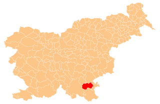
Brezovica pri Črmošnjicah is a small settlement in the Municipality of Semič in Slovenia. The area is part of the historical region of Lower Carniola. The municipality is now included in the Southeast Slovenia Statistical Region.

Gaber pri Črmošnjicah Place in Lower Carniola, Slovenia

Gaber pri Črmošnjicah is a small settlement in the hills west of Semič in southeastern Slovenia. The area is part of the historical region of Lower Carniola and is now included in the Southeast Slovenia Statistical Region.

Ašelice in Lower Carniola, Slovenia

Ašelice is a remote abandoned settlement in the Municipality of Semič in southern Slovenia. The area is part of the traditional region of Lower Carniola and is now included in the Southeast Slovenia Statistical Region. Its territory is now part of the village of Mašelj. Ašelice lies high on a slope alongside an unpaved road east of Črmošnjice.

Smrečnik in Lower Carniola, Slovenia

Smrečnik is a remote abandoned settlement in the Municipality of Semič in southern Slovenia. The area is part of the traditional region of Lower Carniola and is now included in the Southeast Slovenia Statistical Region. Its territory is now part of the village of Komarna Vas.

Gače in Lower Carniola, Slovenia

Gače is a remote abandoned settlement in the Municipality of Semič in southern Slovenia. The area is part of the traditional region of Lower Carniola and is now included in the Southeast Slovenia Statistical Region. Its territory is now part of the village of Komarna Vas and it is registered as a cultural heritage site.

Kleč, Kočevje Place in Lower Carniola, Slovenia

Kleč is a settlement in the Municipality of Kočevje in southern Slovenia. The area is part of the traditional region of Lower Carniola and is now part of the Southeast Slovenia Statistical Region. It no longer has any permanent residents.

Grintovec, Kočevje in Lower Carniola, Slovenia

Grintovec is a remote abandoned settlement in the Municipality of Kočevje in southern Slovenia. The area is part of the traditional region of Lower Carniola and is now included in the Southeast Slovenia Statistical Region. Its territory is now part of the village of Kleč.

Gradec, Črnomelj Place in White Carniola, Slovenia

Gradec is a remote abandoned settlement in the Municipality of Črnomelj in the White Carniola area of southeastern Slovenia. The area is part of the traditional region of Lower Carniola and is now included in the Southeast Slovenia Statistical Region. Its territory is now part of the village of Rožič Vrh.

Kukovo Place in Lower Carniola, Slovenia

Kukovo is a remote abandoned settlement in the Municipality of Dobrepolje in southern Slovenia. The area is part of the traditional region of Lower Carniola and is now included in the Central Slovenia Statistical Region. Its territory is now part of the village of Rapljevo.

Luža, Kočevje in Lower Carniola, Slovenia

Luža is a remote abandoned former settlement in the Municipality of Kočevje in southern Slovenia. The area is part of the traditional region of Lower Carniola and is now included in the Southeast Slovenia Statistical Region. Its territory is now part of the village of Komolec.

Kunč Place in Lower Carniola, Slovenia

Kunč is a remote abandoned settlement in the Municipality of Dolenjske Toplice in southern Slovenia. The area is part of the traditional region of Lower Carniola and is now included in the Southeast Slovenia Statistical Region. Its territory is now part of the village of Podstenice. Northeast of Kunč there is an ice-filled cave called Ice Cave. It is connected to Kunč by a path and people would go to the cave for ice during times of drought.

Lahinja, Semič in Lower Carniola, Slovenia

Lahinja is a remote abandoned settlement in the Municipality of Semič in southern Slovenia. The area is part of the traditional region of Lower Carniola and is now included in the Southeast Slovenia Statistical Region. Its territory is now part of the village of Planina.

Topličice, Semič in Lower Carniola, Slovenia

Topličice is a remote abandoned settlement in the Municipality of Semič in southern Slovenia. The area is part of the traditional region of Lower Carniola and is now included in the Southeast Slovenia Statistical Region. Its territory is now part of the village of Sredgora. It lies in a narrow dry valley 1 km east of Sredgora.

References

  1. 1 2 Intelligenzblatt zur Laibacher Zeitung, no. 141. 24 November 1849, p. 47.
  2. Leksikon občin kraljestev in dežel zastopanih v državnem zboru, vol. 6: Kranjsko. 1906. Vienna: C. Kr. Dvorna in Državna Tiskarna, p. 6.
  3. Ferenc, Mitja. 2007. Nekdanji nemški jezikovni otok na kočevskem. Kočevje: Pokrajinski muzej, p. 4.
  4. Semič municipal site
  5. 1 2 3 Slovenian Ministry of Culture register of national heritage reference number ešd 19515
  6. Snoj, Marko. 2009. Etimološki slovar slovenskih zemljepisnih imen. Ljubljana: Modrijan and Založba ZRC, pp. 188–189.
  7. Simonič, Ivan. 1935. "Kočevarji v luči krajevnih in ledinskih imen." Glasnik Muzejskega društva za Slovenijo 16: 61–81 and 106–123, p. 64.
  8. Petschauer, Erich. 1980. "Die Gottscheer Siedlungen – Ortsnamenverzeichnis." In Das Jahrhundertbuch der Gottscheer (pp. 181–197). Klagenfurt: Leustik.
  9. 1 2 3 4 5 6 7 8 Ferenc, Mitja, & Gojko Zupan. 2012. Izgubljene kočevske vasi, vol. 2 (K–P). Ljubljana: Znanstvena založba Filozofske fakultete Univerze v Ljubljani.
  10. 1 2 Krajevni leksikon Dravske Banovine. 1937. Ljubljana: Zveza za tujski promet za Slovenijo, p. 124.
  11. 1 2 Savnik, Roman, ed. 1971. Krajevni leksikon Slovenije, vol. 2. Ljubljana: Državna založba Slovenije, p. 40.