
Cape Coast is a city, fishing port, and the capital of Cape Coast Metropolitan District and Central Region of Ghana. It is one of the country's most historic cities, a World Heritage Site, home to the Cape Coast Castle, with the Gulf of Guinea situated to its south. According to the 2010 census, Cape Coast had a settlement population of 169,894 people. The language of the people of Cape Coast is Fante.

Keta is a coastal town in the Volta Region of Ghana. It is the capital of the Keta Municipal District.
Ghana is a country of 28.21 million people and many native groups, such as:

The Upper West Region of Ghana is located in the north-western corner of Ghana and is bordered by Upper East region to the east, Northern region to the south, and Burkina Faso to the west and north. The Upper West regional capital and largest settlement is Wa. The Upper West was created by the then Head of State, Flight-Lieutenant Jerry Rawlings in 1983 under the Provisional National Defense Council (PNDC) military regime. The area was carved out of the former Upper Region, which is now the Upper East Region. For about thirty-five years, it remained the youngest region of Ghana until 2018 when six more regions were created by the Nana Addo Dankwa Akufo-Addo government; hence increasing the total number of administrative regions in the country to sixteen.

The Greater Accra Region has the smallest area of Ghana's 16 administrative regions, occupying a total land surface of 3,245 square kilometres. This is 1.4 per cent of the total land area of Ghana. It is the second most populated region, before the Ashanti Region, with a population of 5,455,692 in 2021, accounting for 17.7 per cent of Ghana's total population.

Volta Region is one of Ghana's sixteen administrative regions, with Ho designated as its capital. It is located west of Republic of Togo and to the east of Lake Volta. Divided into 25 administrative districts, the region is multi-ethnic and multilingual, including groups such as the Ewe, the Guan, and the Akan peoples. The Guan peoples include the Lolobi, Likpe, Akpafu, Buem, and Nkonya people. This region was carved out of the Volta Region in December 2018 by the New Patriotic Party.
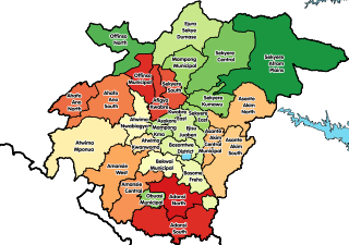
Offinso Municipal District is one of the forty-three districts in Ashanti Region, Ghana. Originally created as an ordinary district assembly in 1988 when it was known as Offinso District, which it was created from the former Offinso District Council; until the northern part of the district was later split off to create Offinso North District on 29 February 2008; while the remaining part was elevated to municipal district assembly status on the same year to become Offinso Municipal District. The municipality is located in the northern part of Ashanti Region and has Offinso as its capital town.

South Dayi District is one of the eighteen districts in Volta Region, Ghana. Originally it was formerly part of the then-larger Kpando District on 10 March 1989, until the southern part of the district was split off by a decree of president John Agyekum Kufuor on 19 August 2004 to create South Dayi District; thus the remaining part has been retained as Kpando District. The district assembly is located in the western part of Volta Region and has Kpeve as its capital town.
Agogo is a town in the Asante Akim North Municipal District of the Ashanti Region of Ghana. Agogo is approximately 80 kilometers east of Kumasi, the capital of the Ashanti Region, and had a population of 28,271 in the 2000 census. Computer projections estimate that the 2007 population was 32,859.
The Ghana Secondary Technical School is a science and technology-oriented high school located in Takoradi on the west coast of Ghana. It is the third oldest high school in Ghana - the oldest 'non-missionary' high school. The School was founded on 9 August 1909 in Accra as Accra Technical School and later changed to Government Technical School. It moved to its current site in Takoradi in 1939. In 1953, the name was changed to Government Secondary Technical School, and in 1970, it was given its current name. Former students of the school are known as Giants, and students in the school are called Tescans.

Akropong is a town in South Ghana and is the capital of the Akuapim North District, a district in the Eastern Region of South Ghana. This town is known for producing snails and palm oil. Akropong has a 2013 settlement population of 13,785 people.
Ogui is an autonomous community in Nike, in Enugu North Local Government Area of Enugu State in the southeastern geopolitical zone of Nigeria. It comprises Umunevo Village, Ihewuzi Village and Onuato Village. Ogui Nike, as it is usually called, is a major landlord to the administrative, political and economic hub of Enugu City, in that major public and private institutions, shopping malls, hotels, banks and so on are situated on Ogui land.
Adukrom is a town in the Okere District Assembly in the Eastern Region of Ghana. It shares borders with Awukugua Akuapem where Okomfo anokye was born The town is known for the Nifahene Stool of Akuapem and the capital of Okere District and situated on the beautiful Togo Atakora hills on the main Ho-Koforidua main trunk road in the northern part of Akuapem
Damongo is a town and the capital of West Gonja Municipal, a municipal in the Savannah Region of northern Ghana. On 12 February 2019, Damongo was declared the capital of the newly created Savannah Region; With the coming into force of the Constitutional Instrument (CI) 105, which was signed into force by the President of the Republic of Ghana and presented to the Yagbonwura in Jubilee House Accra. Damongo hosts the Overlord of the Gonja Kingdom; the Yagbonwura. It is also the capital in the Damongo Constituency whose current MP is Hon. Samuel Abu jinapor
Sandema is the capital town of Builsa North District, a district in the Upper East Region of Ghana.
Anlo Afiadenyigba is a town in the Volta Region of Ghana. The town is located on the eastern part of the Keta Lagoon.
Mepe is a town in the Volta Region of Ghana. The town is known for the St. Kizito Secondary Technical. The school is a second cycle institution. The people of Mepe celebrate the Afenotor Festival.
Ketu South Municipal Assembly formerly Ketu South District, is one of the eighteen districts in Volta Region, Ghana. Originally it was formerly part of the then-larger Ketu District on 10 March 1989, which was created from the former Anlo District Council, until the northern part of the district was split off to create Ketu North District on 29 February 2008; thus the remaining part has been renamed as Ketu South District. It was later elevated to municipal district assembly status on 28 June 2012 to become Ketu South Municipal District. The municipality is located in the southeast part of Volta Region and has Denu as its capital town. The Municipality is known be the largest Kente Production Hub in Ghana.
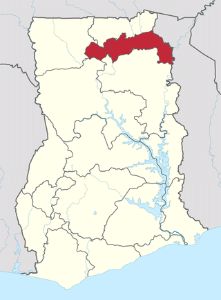
The North East Region is one of the sixteen regions of Ghana. It is located in the north of the country and was created in December 2018 after a referendum was voted upon to break it off of the Northern region. The region's capital is Nalerigu.

Ilara Yewa is a Nigerian town in the west of Ogun State, Nigeria about 91 kilometers northwest of Abeokuta. It lies on the border between Nigeria and Benin. Its elevation is 600 feet above sea level. Ilara Yewa is about 50 kilometers by road from Ketu, a major trading town in Benin. The second-largest settlement, Ilara, merges into Kanga in Benin.