
Franconia is a region of Germany, characterised by its culture and East Franconian dialect . Franconia is made up of the three Regierungsbezirke of Lower, Middle and Upper Franconia in Bavaria, the adjacent, Franconian-speaking, South Thuringia, south of the Thuringian Forest—which constitutes the language boundary between Franconian and Thuringian—and the eastern parts of Heilbronn-Franconia in Baden-Württemberg.

The Swabian Jura, sometimes also named Swabian Alps in English, is a mountain range in Baden-Württemberg, Germany, extending 220 km (140 mi) from southwest to northeast and 40 to 70 km in width. It is named after the region of Swabia.

Swabian is one of the dialect groups of Upper German, sometimes one of the dialect groups of Alemannic German, that belong to the High German dialect continuum. It is mainly spoken in Swabia, which is located in central and southeastern Baden-Württemberg and the southwest of Bavaria. Furthermore, Swabian German dialects are spoken by Caucasus Germans in Transcaucasia. The dialects of the Danube Swabian population of Hungary, the former Yugoslavia and Romania are only nominally Swabian and can be traced back not only to Swabian but also to Franconian, Bavarian and Hessian dialects, with locally varying degrees of influence of the initial dialects.

The Elbe Sandstone Mountains, also called the Elbe Sandstone Highlands, are a mountain range straddling the border between the state of Saxony in southeastern Germany and the North Bohemian region of the Czech Republic, with about three-quarters of the area lying on the German side. In both countries, core parts of the mountain range have been declared a national park. The name derives from the sandstone which was carved by erosion. The river Elbe breaks through the mountain range in a steep and narrow valley.

Diabase, also called dolerite or microgabbro, is a mafic, holocrystalline, subvolcanic rock equivalent to volcanic basalt or plutonic gabbro. Diabase dikes and sills are typically shallow intrusive bodies and often exhibit fine-grained to aphanitic chilled margins which may contain tachylite.

The Riss glaciation, Riss Glaciation, Riss ice age, Riss Ice Age, Riss glacial or Riss Glacial is the second youngest glaciation of the Pleistocene epoch in the traditional, quadripartite glacial classification of the Alps. The literature variously dates it to between about 300,000 to 130,000 years ago and 347,000 to 128,000 years ago. It coincides with the Saale glaciation of North Germany. The name goes back to Albrecht Penck and Eduard Brückner who named this cold period after the river Riss in Upper Swabia in their three-volume work Die Alpen im Eiszeitalter published between 1901 and 1909.

Öhringen is the largest town in Hohenlohe (district) in the state of Baden-Württemberg, in southwest Germany, near Heilbronn. Öhringen is on the railline to Schwäbisch Hall and Crailsheim.

The Murr is a river in Baden-Württemberg, Germany. It is a right tributary of the Neckar. The river gave its name to a small town on its banks, Murr, and to the Rems-Murr-Kreis district, which was also named after the river Rems, which runs roughly parallel to the south of the Murr.

Mössingen is a town in the district of Tübingen, in Baden-Württemberg, Germany. It is situated north of the Swabian Jura, about 13 km south of Tübingen.
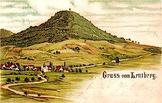
The Lemberg is a mountain located in the Tuttlingen district of Baden-Württemberg, Germany. The mountain is the highest point of the Swabian Jura. It is one of the "Ten Thousanders" —ten 1,000-metre-high summits of the region. On the peak of the mountain is a 30-m-high tower which, reaching above the surrounding trees, offers a beautiful prospect, in clear weather as far as the Alps.
The term Albtrauf refers to the northwest facing escarpment of the Swabian Alps, situated in Baden-Württemberg and Bavaria. It is the most distinctive stepped slope within the alpine region of the South German Scarplands, leading roughly from the southwest to the northeast.

The South German Scarplands is a geological and geomorphological natural region or landscape in Switzerland and the south German states of Bavaria and Baden-Württemberg. The landscape is characterised by escarpments.

Heidengraben is the name given to the remains of a large Celtic fortified settlement (oppidum) dating to the Iron Age, located on the plateau of the Swabian Jura in the districts of Reutlingen and Esslingen in Baden-Württemberg, Germany. The settlement was in use from the 2nd century BC to 1st century BC, during the La Tène period. By surface area, Heidengraben is the largest oppidum in all of mainland Europe.

Franz Manfred Wuketits was an Austrian biologist, university teacher and epistemologist. He wrote extensively on epistemology, the history and theory of biology, evolution theory, evolutionary ethics, evolutionary epistemology and sociobiology.

The Wutach Gorge is a narrow, steep-sided valley in southern Germany through in the upper reaches of the River Wutach with three gorge-like sections, the lowest of which is also called the Wutachflühen. The gorge cuts through the southern part of the Baar region from the eastern side of the High Black Forest heading eastwards to the Trauf the steep, northwestern flank of the Swabian Jura, which transitions to the Randen mountains here.
The Keuper Uplands are part of the South German Scarplands and cover an area of about 3,200 square kilometres.
The Frickenhofer Höhe is hill range, up to 565.4 m above sea level (NHN), in the German state of Baden-Württemberg. Most of the range falls within the county of im Ostalbkreis but its northern spurs reach into Schwäbisch Hall. The elongated plateau-like region is named after the village of Frickenhofen, a settlement on the narrow northwest tip of the hills in the municipality of Gschwend.

The geology of Germany is heavily influenced by several phases of orogeny in the Paleozoic and the Cenozoic, by sedimentation in shelf seas and epicontinental seas and on plains in the Permian and Mesozoic as well as by the Quaternary glaciations.

Siepen,Siefen,Seifen or Seipen are typical regional words used in northwestern Germany for what are often narrow, wet, ravine-like V-shaped valleys of the German Central Uplands with their small headstreams. In the south German region, such valley forms are usually called Klingen.

The Randecker Maar Research Station is a bird observatory which was founded in 1969 by the ornithologist Wulf Gatter. It studies birds, insects and other migratory creatures which tend to concentrate in the pass through the crater of the Randecker Maar as they fly over the Swabian Jura.


