
Kling Klang is the private music studio of the band Kraftwerk. The name is taken from the first song on the Kraftwerk 2 album. The studio was originally located at Mintropstraße 16 in Düsseldorf, Germany, adjacent to Düsseldorf Hauptbahnhof, but in mid-2009 moved to Meerbusch-Osterath, around 10 kilometers west of Düsseldorf. The band also operate a record label named Kling Klang, which they use to release their music.

John Gransfield Kling was an American professional baseball player and manager. He played in Major League Baseball as a catcher from 1900 to 1913, most prominently as a member of the Chicago Cubs teams that won four National League pennants and two World Series championships between 1907 and 1910. He also played for the Boston Braves / Rustlers and the Cincinnati Reds.

The 1954 French Grand Prix was a Formula One motor race held at Reims on 4 July 1954, the same date as the 1954 Football World Cup Final. It was race 4 of 9 in the 1954 World Championship of Drivers. The 61-lap race was won by Mercedes driver Juan Manuel Fangio after he started from pole position. His teammate Karl Kling finished second and Ferrari driver Robert Manzon came in third. This race was held the same day as the 1954 FIFA World Cup Final in Bern, Switzerland, but that event took place later in the day from this Grand Prix.
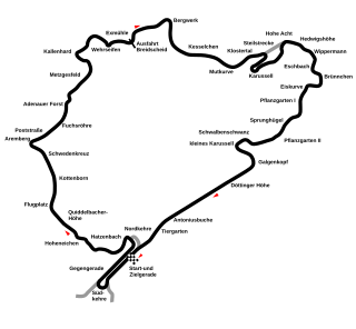
The 1954 German Grand Prix was a Formula One motor race held at Nürburgring on 1 August 1954. It was race 6 of 9 in the 1954 World Championship of Drivers. It was the 17th German Grand Prix since the race was first held in 1926 and the 16th to be held at the Nürburgring complex of circuits. The race was won by 1951 world champion, Argentine driver Juan Manuel Fangio driving a Mercedes-Benz W196. Ferrari 625 drivers Mike Hawthorn and Maurice Trintignant finished second and third for Scuderia Ferrari.

The 1954 Formula One season was the eighth season of FIA Formula One motor racing. It featured the fifth World Championship of Drivers, which was contested over nine races between 17 January and 24 October 1954. The season also included several non-championship races for Formula One cars.

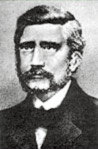
Karl Kling was a motor racing driver and manager from Germany. He participated in 11 Formula One Grands Prix, debuting on 4 July 1954. He achieved 2 podiums - the first German ever to achieve a Formula One podium - and scored a total of 17 championship points.

Kampong Kling Mosque is an old mosque in Malacca City, Malacca, Malaysia. It is situated at Jalan Tukang Emas, also known as "Harmony Street" because of its proximity to the Sri Poyatha Moorthi Temple and Cheng Hoon Teng Temple.
Hugh Asher Stubbins Jr. was an architect who designed several high-profile buildings around the world.

Angelspit is an Australian electronic music band originally from Sydney and currently based in Chicago. The band was formed in 2004 by vocalists/synthesists Destroyx and ZooG. The band's music combines stylistic elements of horror, punk, pop and electronic music. Their work contains imagery revolving around medical experiments and grotesque societies. Angelspit has toured with Angel Theory, Ayria, Ikon, KMFDM, Tankt and The Crüxshadows, and have also shared the stage with bands such as The Sisters of Mercy, Nitzer Ebb, Skinny Puppy and Front Line Assembly. They performed with Lords of Acid during a 22-date U.S. tour in March 2011 and toured the United States with Blood on the Dance Floor in October 2011.
Josef Kling, also found in English-language sources as Joseph Kling, was a German chess master and chess composer. He has been called "a pioneer of the modern style of chess." Although Kling was an expert on endgames and problems, he rarely played competitively.
Woody Kling was an American television writer, producer, playwright, and composer.

My Mercury Mouth E.P is an extended play (EP) by English big beat duo The Chemical Brothers, and their final release under the name The Dust Brothers. The EP contains two new songs, "My Mercury Mouth" and "Dust-Up-Beats", as well as the B-side "If You Kling To Me I'll Klong You", later released on the Japan "Leave Home" single, "Life Is Sweet" CD2 single, and Singles 93–03 releases.

The 2007 Individual Speedway Junior World Championship was the 31st edition of the World motorcycle speedway Under-21 Championships.

Ricky Anders Kling is a Swedish speedway rider from Sweden.

Arnold Kling is an American economist, scholar, and blogger known for his writings on EconLog, an economics blog, along with Bryan Caplan and David R. Henderson. Kling also has his own blog, askblog, which carries the motto: "taking the most charitable views of those who disagree." The "ask" in askblog stands for "Arnold S. Kling." He is an Adjunct Scholar for the Cato Institute and is affiliated with the Mercatus Center.
The Concerto for Two Violins and String Orchestra, Op. 77 by Malcolm Arnold was finished in 1962. It is in three movements:
- Allegro risoluto
- Andantino
- Vivace – Presto
Jeffrey Richard Kling is the research director at the Congressional Budget Office, and was previously the associate director for economic analysis. Kling is also a faculty research fellow at the National Bureau of Economic Research and a senior investigator for the long-term evaluation of the Moving to Opportunity randomized housing mobility experiment.
Khua kling is a spicy, dry-fried curry from Thai cuisine originating from the Southern Region. The primary components are meat and Southern Thai style red curry paste. Unlike most curries that are cooked in a spicy sauce, the dry meat style directly seasons the meat. When dry-frying the meat its fat renders allowing the curry paste to adhere.

Kuaishou Technology is a Chinese publicly traded partly state-owned holding company based in Haidian District, Beijing, that was founded in 2011 by Hua Su (宿华) and Cheng Yixiao (程一笑). The company is known for developing a mobile app for sharing users' short videos, a social network, and video special effects editor.

SerenityOS is a free and open source desktop operating system that has been in continuous development since 2018. Initially a one-man project of Swedish programmer Andreas Kling, SerenityOS is now developed by a community of hobbyists. The system supports the x86-64 instruction set, features a preemptive kernel, and hosts multiple complex applications including its own web browser and integrated development environment (IDE).


