Related Research Articles

Breedon on the Hill is a village and civil parish about 5 miles (8 km) north of Ashby-de-la-Zouch in North West Leicestershire, England. The parish adjoins the Derbyshire county boundary and the village is only about 2 miles (3 km) south of the Derbyshire town of Melbourne. The 2001 Census recorded a parish population of 958 people in 404 households. The parish includes the hamlets of Tonge 1 mile (1.6 km) east of the village and Wilson 1.3 miles (2 km) north of the village on the county boundary. The population at the 2011 census was 1,029 in 450 households.

The Fosse Way was a Roman road built in England during the first and second centuries CE that linked Exeter in the southwest and Lincoln to the northeast, via Ilchester, Bath, Cirencester and Leicester.

The Jewry Wall is a substantial ruined wall of 2nd-century Roman masonry, with two large archways, in Leicester, England. It stands alongside St Nicholas' Circle and St Nicholas' Church. It formed the west wall of a public building in Ratae Corieltauvorum, alongside public baths, the foundations of which were excavated in the 1930s and are also open to view. The wall gives its name to the adjacent Jewry Wall Museum.

Kegworth is a large village and civil parish in the North West Leicestershire district of Leicestershire, in the English East Midlands region. It forms part of the border with Nottinghamshire and is situated 6 miles north of Loughborough, 12 miles southwest of Nottingham, 12.5 miles southeast of Derby and 17 miles north of Leicester. The population of Kegworth as of the 2011 census was 3,601.
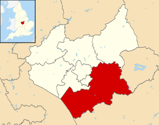
Harborough is a local government district of Leicestershire, England, named after its main town, Market Harborough. Covering 230 square miles (600 km2), the district is by far the largest of the eight district authorities in Leicestershire and covers almost a quarter of the county.
Gartree was a hundred of Leicestershire.

Wymeswold is a village and civil parish in the Charnwood district of Leicestershire, England. It is in the north of Leicestershire, and north-east of Loughborough. The village has a population of about 1,000, measured at 1,296 in the 2011 census. It is close to Prestwold and Burton on the Wolds in Leicestershire, and the Nottinghamshire villages of Rempstone and Willoughby on the Wolds.

Great Easton is a village and civil parish in the Harborough district of Leicestershire, England. The parish had a population of 558 according to the 2001 census, increasing to 671 at the 2011 census.

Glooston is a small village and civil parish in the Harborough district of Leicestershire, England. According to the 2001 census the parish had a population of 54, increasing to 147 at the 2011 census.

Goadby Marwood is a village in the north of the English county of Leicestershire. It is about 6 miles (10 km) north of Melton Mowbray and a few miles from the Vale of Belvoir. The population is included in the civil parish of Eaton.

Stockerston is a village and civil parish in the Harborough district of Leicestershire, England, located on the border with Rutland, by the Eye Brook. According to the 2001 census the parish had a population of 35. The population remained less than 100 at the 2011 census and is included in the civil parish of Horninghold.

Diseworth is a village in the English county of Leicestershire. It is south of East Midlands Airport and off Junction 23A of the M1 motorway.

Swinford is a nucleated village and civil parish in the Harborough district of the English county of Leicestershire. The population of the civil parish at the 2011 census was 586. It used to be on the former A427, which led under the M1, to Catthorpe. The parish church is All Saints, a 12th-century Norman rebuilding of an earlier Saxon church with a 14th-century square bell tower and a Grade II* listed building. The local pub is The Chequers on the High Street, formerly known as Chequer Inn.
Edenham is a village and civil parish in the South Kesteven district of Lincolnshire, England. It is approximately 3 miles (5 km) north-west of Bourne, and on the A151 road. While the civil parish is called "Edenham", the parish council is called Edenham, Grimsthorpe, Elsthorpe & Scottlethorpe Parish Council. The population of the civil parish at the 2011 census was 291. The parish is principally located in the valley of the East Glen which flows through the village.

Wyville with Hungerton, or Hungerton-cum-Wyville is a village and civil parish in the South Kesteven district of Lincolnshire, England, and situated approximately 5 miles (8 km) south-west from Grantham The whole parish covers about 1,670 acres (6.8 km2). The population is included in the civil parish of Little Ponton and Stroxton.
The River Eye is a river in north-eastern Leicestershire that becomes the Wreake.

Wilson, in the English county of Leicestershire, is a small hamlet just outside Melbourne, Derbyshire. Close to East Midlands Airport, Wilson retains many 'village-like' features. It has one pub, the Bulls Head. Wilson has no amenities other than a golf course, gym and swimming pool. Its name is first recorded in the 12th century as Wiuelestunia and likely came from Anglo-Saxon Wifeles tūn = "Wifel's farmstead or village". In 1870-72 it had a population of 177.
The identification of Deserted Villages and Lost Places in Leicestershire owes much to the pioneering work of William George Hoskins during his time at the University of Leicester.

Zouches Manor was an Anglo-Saxon moated manor in Fulbourn Fen, a Site of Special Scientific Interest in the village of Fulbourn, Cambridgeshire, England. It is one of the historic Five Manors of Fulbourn and recorded to have existed 1066 AD to 1539 AD.
References
- ↑ Knave Hill, Stonton Wyville, Leicestershire: Archaeological Evaluation and Assessment of Results (PDF). Wessex Archaeology. May 2008. Retrieved 16 July 2010.