Knighton | |
---|---|
| |
Area | |
• 1911 | 88,872 acres (359.65 km2) |
• 1931 | 88,872 acres (359.65 km2) |
• 1961 | 88,872 acres (359.65 km2) |
Population | |
• 1901 | 4,856 |
• 1931 | 3,955 |
• 1971 | 2,595 |
History | |
• Origin | Sanitary district |
• Created | 1894 |
• Abolished | 1974 |
• Succeeded by | Radnorshire |
Status | Rural district |
Government | Knighton Rural District Council |
• HQ | Knighton |
Subdivisions | |
• Type | Civil parishes |
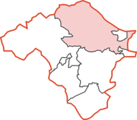
Knighton was, from 1894 to 1974, a rural district in the administrative county of Radnorshire, Wales.
The district was formed by the Local Government Act 1894, when the existing Knighton Rural Sanitary District was divided into three: the section in Herefordshire was reconstituted as Wigmore Rural District, that in Shropshire as Teme Rural District, while the remaining section in Radnorshire became Knighton Rural District. [1] The rural district council was based in the town of Knighton which was a separate urban district.
The rural district comprised seventeen civil parishes: [2]
The district was abolished in 1974 under the Local Government Act 1972, which completely reorganised local administration in England and Wales. Its area became part of the District of Radnor in the new county of Powys.
Powys is a county and preserved county in Wales. It borders Gwynedd, Denbighshire, and Wrexham to the north; the English ceremonial counties of Shropshire and Herefordshire to the east; Monmouthshire, Blaenau Gwent, Merthyr Tydfil, Caerphilly, Rhondda Cynon Taf, and Neath Port Talbot to the south; and Carmarthenshire and Ceredigion to the west. The largest settlement is Newtown, and the administrative centre is Llandridnod Wells.
Montgomeryshire is one of thirteen historic counties and a former administrative county of Wales. It is named after its county town, Montgomery, which in turn is named after one of William the Conqueror's main counsellors, Roger de Montgomerie, who was the 1st Earl of Shrewsbury.
Radnorshire is one of the thirteen historic counties of Wales and a former administrative county. It covers a sparsely populated area in mid Wales. The historic county was bounded to the north by Montgomeryshire and Shropshire, to the east by Herefordshire, to the south by Brecknockshire and to the west by Cardiganshire.
Knighton is a market town and community on the River Teme, straddling the border between Powys, Wales and Shropshire, England. It lies in the traditional county of Radnorshire. Originally an Anglo-Saxon settlement, Knighton is located on Offa's Dyke, the ancient earthwork that divided the two countries. It later became a Norman defensive border town.
Radnor Forest is a rock dome composed of Silurian shales, mudstones and limestone in the historic county of Radnorshire, Powys, Mid Wales. It is a forest in the medieval sense of the word. It lies within the Welsh Marches region since Offa's Dyke lies nearby to the east.
Ketton was a rural district in Rutland, England from 1894 to 1974, covering the east of the county. The district was named after Ketton.
Banbury was a rural district in Oxfordshire, England from 1894 to 1974. It was formed under the Local Government Act 1894 from the bulk of the Banbury rural sanitary district, which had been divided among three counties. The Warwickshire part of the rural sanitary district formed the Farnborough Rural District, whilst the area in Northamptonshire formed the Middleton Cheney Rural District.
Sanitary districts were established in England and Wales in 1872 and in Ireland in 1878. The districts were of two types, based on existing structures:
The Local Government Act 1929 was an Act of the Parliament of the United Kingdom that made changes to the Poor Law and local government in England and Wales.
The Local Government Act 1933 was an Act of the Parliament of the United Kingdom that consolidated and revised existing legislation that regulated local government in England and Wales. It remained the principal legislation regulating local government until the Local Government Act 1972 took effect in 1974.
The District of Radnorshire was one of three local government districts of the county of Powys, Wales, from 1974 until 1996. The district had an identical area to the previous administrative county of Radnorshire. The district was abolished in 1996, with Powys County Council taking over its functions.
The history of local government in Wales in a recognisably modern form emerged during the late 19th century. Administrative counties and county boroughs were first established in Wales in 1889. Urban and rural districts were formed in 1894. These were replaced in 1974 by a two-tier authority system across the country comprising eight counties and, within them, thirty-seven districts. This system was itself replaced by the introduction of 22 single-tier authorities in 1996.
Edeirnion or Edeyrnion is an area of the county of Denbighshire and an ancient commote of medieval Wales in the cantref of Penllyn. According to tradition, it was named after its eponymous founder Edern or Edeyrn. It was included as a Welsh territory of Shropshire in the Domesday Book.
Colwyn was, from 1894 to 1974, a rural district in the administrative county of Radnorshire, Wales.
Painscastle was, from 1894 to 1974, a rural district in the administrative county of Radnorshire, Wales.
New Radnor was, from 1894 to 1974, a rural district in the administrative county of Radnorshire, Wales.
Rhayader was, from 1894 to 1974, a rural district in the administrative county of Radnorshire, Wales.
Newtown and Llanllwchaiarn is a local government community in mid Powys, Wales. It includes the town of Newtown and the small neighbouring village of Llanllwchaiarn. At the time of the 2011 census the population of the community was 11,357. The community council is called Newtown and Llanllwchaiarn Town Council, often abbreviated to Newtown Town Council.