Bodzanówek is a village in the administrative district of Gmina Osięciny, within Radziejów County, Kuyavian-Pomeranian Voivodeship, in north-central Poland.

Woziwoda is a village in the administrative district of Gmina Tuchola, within Tuchola County, Kuyavian-Pomeranian Voivodeship, in north-central Poland. It lies approximately 10 kilometres (6 mi) north-east of Tuchola and 62 km (39 mi) north of Bydgoszcz.
Szlasy-Łopienite is a village in the administrative district of Gmina Rutki, within Zambrów County, Podlaskie Voivodeship, in north-eastern Poland.
Kociołki is a village in the administrative district of Gmina Błaszki, within Sieradz County, Łódź Voivodeship, in central Poland. It lies approximately 5 kilometres (3 mi) north-east of Błaszki, 21 km (13 mi) north-west of Sieradz, and 69 km (43 mi) west of the regional capital Łódź.

Prusy is a village in the administrative district of Gmina Kocmyrzów-Luborzyca, within Kraków County, Lesser Poland Voivodeship, in southern Poland. It lies approximately 12 km (7 mi) north-east of the regional capital Kraków.
Brzozowo-Łęg is a village in the administrative district of Gmina Dzierzgowo, within Mława County, Masovian Voivodeship, in east-central Poland.
Trzcianka-Kolonia is a village in the administrative district of Gmina Szydłowo, within Mława County, Masovian Voivodeship, in east-central Poland. It lies approximately 4 kilometres (2 mi) west of Szydłowo, 6 km (4 mi) south-east of Mława, and 104 km (65 mi) north-west of Warsaw.
Trzaski is a village in the administrative district of Gmina Troszyn, within Ostrołęka County, Masovian Voivodeship, in east-central Poland. It lies approximately 9 kilometres (6 mi) north-east of Troszyn, 19 km (12 mi) east of Ostrołęka, and 111 km (69 mi) north-east of Warsaw.
Borkowo-Boksy is a village in the administrative district of Gmina Czernice Borowe, within Przasnysz County, Masovian Voivodeship, in east-central Poland.

Lubiatów is a village in the administrative district of Gmina Otmuchów, within Nysa County, Opole Voivodeship, in south-western Poland, close to the Czech border. It lies approximately 9 kilometres (6 mi) north-west of Otmuchów, 19 km (12 mi) west of Nysa, and 64 km (40 mi) west of the regional capital Opole.
Płocicz is a village in the administrative district of Gmina Koczała, within Człuchów County, Pomeranian Voivodeship, in northern Poland. It lies approximately 5 kilometres (3 mi) south of Koczała, 31 km (19 mi) north-west of Człuchów, and 117 km (73 mi) south-west of the regional capital Gdańsk.
Starzno is a village in the administrative district of Gmina Koczała, within Człuchów County, Pomeranian Voivodeship, in northern Poland. It lies approximately 8 kilometres (5 mi) north of Koczała, 41 km (25 mi) north-west of Człuchów, and 111 km (69 mi) south-west of the regional capital Gdańsk.
Laskówko is a village in the administrative district of Gmina Barlinek, within Myślibórz County, West Pomeranian Voivodeship, in north-western Poland.
Kolonia Dolna-Grabowo is a settlement in the administrative district of Gmina Stargard, within Stargard County, West Pomeranian Voivodeship, in north-western Poland. It lies approximately 6 kilometres (4 mi) north-east of Stargard and 33 km (21 mi) east of the regional capital Szczecin.
Kądzielnia is a settlement in the administrative district of Gmina Borne Sulinowo, within Szczecinek County, West Pomeranian Voivodeship, in north-western Poland. It lies approximately 11 kilometres (7 mi) north of Borne Sulinowo, 9 km (6 mi) south-west of Szczecinek, and 136 km (85 mi) east of the regional capital Szczecin.
Sobiemirowo is a settlement in the administrative district of Gmina Sławoborze, within Świdwin County, West Pomeranian Voivodeship, in north-western Poland. It lies approximately 5 kilometres (3 mi) south-west of Sławoborze, 11 km (7 mi) north-west of Świdwin, and 88 km (55 mi) north-east of the regional capital Szczecin.

Lindbergh is a hamlet in central Alberta, Canada within the County of St. Paul No. 19. It is located approximately 17 kilometres (11 mi) east of Highway 41 and 77 kilometres (48 mi) northwest of Lloydminster.
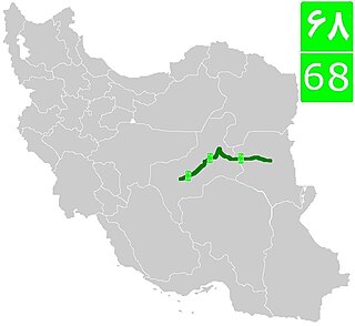
Road 68 is a road in central and eastern Iran in dry areas. It connects Yazd in Yazd Province, to Birjand in South Khorasan Province.

Zbazhdi is a village in Municipality of Struga, Macedonia.
Jabłonka is a village in the administrative district of Gmina Śliwice, within Tuchola County, Kuyavian-Pomeranian Voivodeship, in north-central Poland. It lies approximately 350 metres (1,148 ft) north-east of Brzozowe Błota, 5.6 kilometres (3 mi) south-west of Śliwice, 21.7 km (13 mi) north-east of Tuchola, and 68.2 km (42 mi) north of Bydgoszcz.


