Ko Sai

Last updated
Ko Sai

เกาะทราย
Ko Sai.JPG
Ko Sai island (left) seen from the shore. Ko Khi Nok (center) and Ko Sadao island (right) are smaller.
Thailand adm location map.svg
Red pog.svg
Ko Sai
Coordinates: 12°29′N100°0′E / 12.483°N 100.000°E / 12.483; 100.000
Country Thailand
Province Prachuap Khiri Khan
Amphoe Hua Hin
Elevation
35 m (115 ft)

Ko Sai (เกาะทราย) is one of the gulf islands of Thailand. It lies on the west side of the Gulf of Thailand, about 2 km off-shore. [1]

Thailand Constitutional monarchy in Southeast Asia

Thailand, officially the Kingdom of Thailand and formerly known as Siam, is a country at the centre of the Southeast Asian Indochinese peninsula composed of 76 provinces. At 513,120 km2 (198,120 sq mi) and over 68 million people, Thailand is the world's 50th largest country by total area and the 21st-most-populous country. The capital and largest city is Bangkok, a special administrative area. Thailand is bordered to the north by Myanmar and Laos, to the east by Laos and Cambodia, to the south by the Gulf of Thailand and Malaysia, and to the west by the Andaman Sea and the southern extremity of Myanmar. Its maritime boundaries include Vietnam in the Gulf of Thailand to the southeast, and Indonesia and India on the Andaman Sea to the southwest. Although nominally a constitutional monarchy and parliamentary democracy, the most recent coup in 2014 established a de facto military dictatorship.

Gulf of Thailand A shallow inlet in the western part of the South China Sea

The Gulf of Thailand, also known as the Gulf of Siam, is a shallow inlet in the western part of the South China Sea, a marginal body of water in the western Pacific Ocean. The gulf is around 800 km (497 mi) long and up to 560 km (348 mi) wide, has a surface area of 320,000 km2 (123,553 sq mi) and is surrounded on the north, west and southwest by Thailand, on the northeast by Cambodia and Vietnam. The South China Sea is to the southeast.

Contents

Geography

Ko Sai is the largest of a group of three rocky islets also known as "Pran Rocks", off the fishing village of Khao Takiab, just south of Hua Hin. This area belongs administratively to Prachuap Khiri Khan Province.

Prachuap Khiri Khan Province Province in Thailand

Prachuap Khiri Khan is one of the western provinces (changwat) of Thailand. It is in the northern part of the Malay Peninsula, some 240 km (150 mi) south of Bangkok. Neighboring provinces are Phetchaburi to the north and Chumphon to the south. To the west it borders Tanintharyi Region of Myanmar.

Ko Sai has a maximum length of 0.4 km and its highest point reaches 35 m. Ko Sai vaguely resembles a sitting lion when seen from shore. Local tour operators call it "Lion Island" (Ko Singto) and organize regular sightseeing and snorkeling excursions to visit it. [2]

Adjacent islands

Two smaller islets are close to Ko Sai:

Ko Tao Place in Surat Thani, Thailand

Ko Tao is an island in Thailand and is part of the Chumphon Archipelago on the western shore of the Gulf of Thailand. It covers an area of about 21 km2. Administratively it forms a district (amphoe) of Surat Thani Province. As of 2006 its official population was 1,382. The main settlement is Ban Mae Hat.

Surat Thani Province Province in Thailand

Surat Thani, often shortened to Surat, is the largest of the southern provinces (changwat) of Thailand. It lies on the western shore of the Gulf of Thailand. Surat Thani means "city of good people", a title given to the city by King Vajiravudh.

Guano excrement of seabirds and bats

Guano is the accumulated excrement of seabirds and bats. As a manure, guano is a highly effective fertilizer due to its exceptionally high content of nitrogen, phosphate and potassium: nutrients essential for plant growth. Guano was also, to a lesser extent, sought for the production of gunpowder and other explosive materials. The 19th-century guano trade played a pivotal role in the development of modern input-intensive farming, but its demand began to decline after the discovery of the Haber-Bosch process of nitrogen fixing led to the production of synthetic fertilizers. The demand for guano spurred the human colonization of remote bird islands in many parts of the world. During the 20th century, guano-producing birds became an important target of conservation programs and influenced the development of environmental consciousness. Today, guano is increasingly sought after by organic farmers.

Related Research Articles

Chumphon Province Province in Thailand

Chumphon is a southern province (changwat) of Thailand on the Gulf of Thailand. Neighbouring provinces are Prachuap Khiri Khan, Surat Thani, and Ranong. To the west it borders the Burmese province of Tanintharyi.

Songkhla Province Province in Thailand

Songkhla is one of the southern provinces (changwat) of Thailand. Neighboring provinces are Satun, Phatthalung, Nakhon Si Thammarat, Pattani, and Yala. To the south it borders Kedah and Perlis of Malaysia.

Phi Phi Islands Archipelago in Krabi, Thailand

The Phi Phi Islands are an island group in Thailand, between the large island of Phuket and the Straits of Malacca coast of Thailand. The islands are administratively part of Krabi Province. Ko Phi Phi Don is the largest and most populated island of the group, although the beaches of the second largest island, Ko Phi Phi Le are visited by many people as well. The rest of the islands in the group, including Bida Nok, Bida Nai, and Bamboo Island, are not much more than large limestone rocks jutting out of the sea. The islands are reachable by speedboats or long-tail boats most often from Krabi town or from piers in Phuket Province.

Ko Samui Island in Surat Thani, Thailand

Ko Samui is an island off the east coast of the Kra Isthmus, Thailand. Geographically in the Chumphon Archipelago, it is part of Surat Thani Province, though as of 2012, Ko Samui was granted municipal status and thus is now locally self-governing. Ko Samui is Thailand's second-largest island after Phuket, with an area of 228.7 km2, a population of over 63,000 and a hotel occupancy rate of 73 percent as the number of visitors continues to increase. Abundant tourist resources, sandy beaches, coral reefs, and coconut trees are present on the island.

Ko Pha-ngan island in Surat Thani, Thailand

Ko Pha-ngan is an island in the Gulf of Thailand in southeast Thailand in Surat Thani Province. Ko Pha-ngan is best known for its Full Moon Party at Haad Rin Beach. Ko Pha-ngan has two sister islands: the larger Ko Samui to the south and the smaller Ko Tao to the north.

Chumphon Town in Chumphon Province, Thailand

Chumphon is a town in southern Thailand, capital of the Chumphon Province and Mueang Chumphon District. The city is about 463 kilometers from Bangkok. As of 2005 it had a population of 33,522. The town covers the commune (tambon) Tha Taphao completely and parts of tambons Bang Mak, Wang Phai, Na Thung, Tak Daet, and Khun Krathing. Its main economic activity is agriculture.

Southern Thailand Region in Hat Yai

Southern Thailand is a southernmost cultural region of Thailand, separated from Central Thailand region by the Kra Isthmus.

Ko Chang District District in Trat, Thailand

Ko Chang is an amphoe (district) in Trat Province, Thailand. It is on the Gulf of Thailand's eastern seaboard, 310 km from Bangkok, near the border with Cambodia.

Ko Samet island in the Gulf of Thailand

Ko Samet is one of the eastern seaboard islands of Thailand. It is in the Gulf of Thailand off the coastline of the Thai province of Rayong, approximately 220 kilometres (140 mi) southeast of Bangkok. Ko Samet is part of the Phe Subdistrict of the Amphoe Mueang Rayong, of Rayong Province. Ko Samet is the largest and westernmost of a cluster of islands not far from the coast. Ko Samet measures 6.8 kilometres (4.2 mi) from north to south. At its closest point to the mainland, the island is 2.6 kilometres (1.6 mi) south of mainland Rayong Province; however the actual travelling distance from the main commercial tourist pier in the town of Phe to the island's closest tourist beach is about 10 kilometres (6.2 mi).

Sadao District District in Songkhla, Thailand

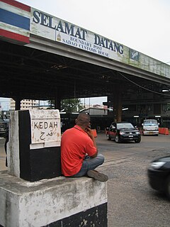
Sadao is district (amphoe) on the border of Malaysia in Songkhla Province, southern Thailand.

Malaysia–Thailand border international border

The Malaysia–Thailand border consists of both a land boundary across the Malay Peninsula and maritime boundaries in the Straits of Malacca and the Gulf of Thailand/South China Sea. Malaysia lies to the south of the border while Thailand lies to the north. The Golok River forms the easternmost 95 km stretch of the land border.

Mu Ko Phetra National Park national park of Thailand

Mu Ko Phetra is a marine national park in the Strait of Malacca off Thailand, covering mostly intact coastal line, open water, and about 30 islands of the southern part of Trang Province and the northern part of Satun Province. Established on 31 December 1984, it is the 49th national park and 14th marine national park of Thailand.

Ko Lan Island in Chonburi, Thailand

Ko Lan is one of the eastern seaboard islands of Thailand. Ko Lan lies 7.5 km from the nearest shore, Pattaya. "Ko Lan" is the name of the island in the Royal Thai General System of Transcription. It is also known as "Koh Larn" and "Ko Laan".

Ko Losin islet in the Gulf of Thailand

Ko Losin is a small rocky islet in the southern area of the Gulf of Siam. It is under the Panare District of the Pattani Province of Thailand.

Ko Kra archipelago in the Gulf of Thailand

Ko Kra is a group of small rocky islets in the southern area of the Gulf of Thailand. It is under the administration of Nakhon Si Thammarat Province of Thailand.

Ko Phai Island in Chonburi Province, Thailand

Ko Phai is the largest island in Mu Ko Phai (หมู่เกาะไผ่), a small uninhabited archipelago on the eastern seaboard of Thailand. It is about 21 km to the west of Pattaya. It is also known as "Koh Pai". It is also mentioned as "Bamboo Island", the meaning of its name in Thai, in tourist guides.

Ko Khram Island in Chonburi Province, Thailand

Ko Khram (เกาะคราม), also known as Ko Khram Yai, is an island in Bangkok Bay located about 24 km to the SSW of Pattaya. It is the largest of the eastern seaboard islands of Thailand and the largest island in the bay.

References

  1. Hydrographic Service of the Royal Thai Navy, Chart 001
  2. Alternative names

See also