This article is written like a travel guide rather than an encyclopedic description of the subject. Please help improve it by rewriting it in an encyclopedic style. If a travel guide is intended, use of Wikivoyage is strongly suggested.(November 2019)
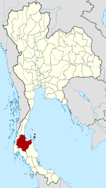
Surat Thani (Thai: สุราษฎร์ธานี, pronounced[sù.râːt tʰāː.nīː]), often shortened to Surat, is the largest of the southernprovinces (changwat) of Thailand. It lies on the western shore of the Gulf of Thailand. Surat Thani means 'city of good people', a title given to the city by King Vajiravudh (Rama VI); Surat Thani is therefore the sole province in Southern Thailand for which the native name is in the Central Thai language.
Geographically, the centre of the province is the coastal plain of the Tapi River, mostly grassland interspersed with rubber trees and coconut plantations. In the west are the limestone mountains of the Phuket range which are mostly covered with forest. Khao Sok National Park is found there. To the east the hills of the Nakhon Si Thammarat (or Bantat) mountain range start to rise, protected in the Tai Rom Yen National Park. The total forest area is 3,764km2 (1,453sqmi) or 28.8 percent of provincial area.[4]
The main rivers of Surat Thani Province are the Tapi River and the Phum Duang River, which join at the town Tha Kham shortly before they flow into Bandon Bay. The delta of these rivers, locally known as Nai Bang (ในบาง), is directly north of the city of Surat Thani. It consists of several channels with small islands mostly covered by mangroves and orchards.
The area of Surat Thani was already inhabited in prehistoric times by Semang and Malayan tribes. Founded in the 3rd century, the Srivijaya kingdom dominated the Malay Peninsula until the 13th century. The city of Chaiya contains ruins from the Srivijaya period, and it was probably a regional capital of the kingdom. Some Thai historians even argue that it was the kingdom's capital for a time, but this is disputed. Wiang Sa was another important settlement of the time.
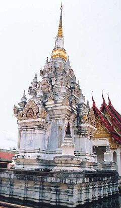
Wat Kaew in Chaiya, dating from Srivijavan times
After the fall of the Srivijaya, the area was divided into the cities (mueang) of Chaiya, Thatong (now Kanchanadit), and Khirirat Nikhom. Chaiya was administered directly from the Thai capital, while Thatong and Khirirat were controlled by the Nakhon Si Thammarat Kingdom. In 1899, they were all merged into a single province called Chaiya. In 1915, the court of the MonthonChumphon was transferred to Bandon, which received the new name of Surat Thani on 29 July 1915, during a visit of King Vajiravudh (Rama VI). This was likely influenced by the major port city of Surat in Gujarat, India. The monthon was also renamed Surat. In 1926 it was abolished and incorporated into monthon Nakhon Si Thammarat. The monthon was dissolved in 1933, and the province became a first level administrative subdivision.
Srivijaya-style pagoda, Chaiya
The provincial administration was in a building in Tha Kham (Phunphin District). Shortly before World War II, it was moved to the city of Surat Thani, on the banks of the Tapi River, which is named after the Tapi River in southern Gujarat, India. When the Japanese invaded Thailand on 8 December 1941, the administrative building was destroyed during the battle for the city. It was rebuilt in 1954, but on 19 March 1982, a bomb planted by communist rebels blew up the building, killing five people. The third and present building was relocated to the south of the city, and the former site of the provincial hall is now the site of the city pillar shrine (Lak Mueang).
Symbols
The seal of the province shows the pagoda of Wat Phra Borommathat Chaiya, which is believed to have been built 1,200 years ago.[5] The flag of the province shows the pagoda in middle, placed on a horizontally split flag with red color on top and yellow on the bottom.
The provincial slogan is "เมืองร้อยเกาะ เงาะอร่อย หอยใหญ่ ไข่แดง แหล่งธรรมะ ชักพระประเพณี", 'city of 100 islands, delicious rambutan, big shells and red eggs, center of Buddhism'. "Red eggs" are a local culinary specialty of pickled duck eggs, while the "big shells" refers to historically abundant shellfish available. "Center of Buddhism" refers to the Chaiya pagoda and Chak Phra Festivals.
Administrative divisions
Map of 19 districts
Provincial government
The province is divided into 19 districts (amphoes), which are further divided into 131 subdistricts (tambons) and 1,028 villages (mubans).
As of 26 November 2019 there are:[6] one Surat Thani Provincial Administration Organisation (ongkan borihan suan changwat) and 40 municipal (thesaban) areas in the province. Surat Thani and Ko Samui have city (thesaban nakhon) status. Tha Kham, Na San and Don Sak have town (thesaban mueang) status. Further 35 subdistrict municipalities (thesaban tambon). The non-municipal areas are administered by 97 Subdistrict Administrative Organisations - SAO (ongkan borihan suan tambon).[2]
For national elections, the province is divided into two constituencies, each eligible to elect three members of parliament.
Economy
In the 2008 census, the province had a GPP of 132,637.3 million baht (US$4,019.31 million) and GPP per capita of 134,427 (US$4,073.54)[citation needed] compared with a GPP of 122,398 million baht (US$3,599.94 million) and GPP per capita of 125,651 baht (US$3,695.62) in the 2007 census, with a GPP growth rate of 8.37 percent and per capita growth rate of 6.98 percent.
The main agricultural products of the province are coconut and rambutan. The coconuts are often picked from the tree by specially trained monkeys, mostly pig-tailed macaques (Macaca nemestrina). The monkey school of the late Somporn Saekhow is the most known training centre. Rambutan trees were first planted in Surat Thani in 1926 by the Chinese Malay Mr. K. Vong in Ban Na San District. An annual rambutan fair is held in early-August and includes a parade of highly decorated floats on the Tapi River. Rubber tree plantations are also common in the province.
A notable local product is the hand-woven silk cloth from the coastal village Phum Riang in Chaiya District. Chaiya is also the most famous source of red eggs, a local specialty. Ducks are fed with crabs and fish and the eggs are then preserved by placing them in a soil-salt mixture.
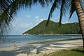
Tourism is the major source of provincial income. The province earned 64 billion baht from tourism in 2018. That revenue accounted for 63 percent of Surat Thani's overall tourism income, most of it attributable to its island attractions: Ko Samui, Ko Pha Ngan, Ko Tao, and Mu Ko Ang Thong National Park.[7]
Human achievement index 2017
Health
Education
Employment
Income
28
50
59
15
Housing
Family
Transport
Participation
73
37
30
70
Province Surat Thani, with an HAI 2017 value of 0.5476 is "low", occupies place 65 in the ranking.
Since 2003, United Nations Development Programme (UNDP) in Thailand has tracked progress on human development at sub-national level using the Human achievement index (HAI), a composite index covering all the eight key areas of human development. National Economic and Social Development Board (NESDB) has taken over this task since 2017.[3]
Rank
Classification
1 - 15
"high"
16 - 30
"somewhat high"
31 - 45
"average"
45 - 60
"somewhat low"
61 - 77
"low"
Map with provinces and HAI 2017 rankings
National parks
Mu Ko Ang Thong National Park is a marine national park in the Gulf of Thailand.[8] It covers 42 islands and a total area of 102km2, of which about 50km2 are land and the rest is water. The park was established on 12 November 1980.[9] The northern tip of Ko Phaluai is also part of the marine park. There is a ranger station, bungalows, a shop, and a restaurant at Ao Phi Beach on Ko Wua Talap.
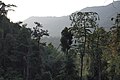
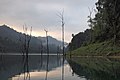
Khao Sok National Park is the largest area of virgin forest in southern Thailand and is a remnant of rain forest which is older and more diverse than the Amazon rain forest.
Nakhon Si Thammarat Province (Thai: จังหวัดนครศรีธรรมราช, pronounced [ná .kʰɔ̄ːn sǐː tʰām.mā.râːt]; often shortened to Nakhon, Nakhon Si, Khon, internationally known as Muang Khon is one of the southern provinces of Thailand, on the western shore of the Gulf of Thailand. Neighboring provinces are Songkhla, Phatthalung, Trang, Krabi and Surat Thani.
Monthon were administrative subdivisions of Thailand at the beginning of the 20th century. The Thai word monthon is a translation of the word mandala, in its sense of a type of political formation. The monthon were created as a part of the Thesaphiban bureaucratic administrative system, introduced by Prince Damrong Rajanubhab which, together with the monthon, established step-by-step today's present provinces (changwat), districts (amphoe), and communes (tambon) throughout Thailand. Each monthon was led by a royal commissioner called Thesaphiban (เทศาภิบาล), later renamed to Samuhathesaphiban (สมุหเทศาภิบาล). The system was officially adopted by the 1897 Local Administration Act, after some monthon had been established and administrative details were sorted out.
Surat Thani is a city in Amphoe Mueang Surat Thani, Surat Thani Province, southern Thailand. It lies 651 km (405 mi) south of Bangkok. It is the capital of Surat Thani Province. The city has a population of 132,040 (2019), and an area of 68.97 km2 (26.63 sq mi). The city's population density is 1,914 inhabitants per km2.
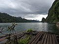
Khao Sok National Park is in Surat Thani Province, Thailand. Its area is 739 km2 (285 sq mi), and it includes the 165 km2 (64 sq mi) Cheow Lan Lake contained by the Ratchaprapha Dam. The park is the largest area of virgin forest in southern Thailand and is a remnant of rain forest which is older and more diverse than the Amazon rain forest.
Kanchanadit is a district (amphoe) in Surat Thani Province, south Thailand.
Southern Thailand, Southern Siam or Tambralinga is a southernmost cultural region of Thailand, separated from Central Thailand region by the Kra Isthmus.
The Tapi river is the longest river in southern Thailand. The river originates at Khao Luang mountain in Nakhon Si Thammarat Province, and empties into the Gulf of Thailand at Bandon Bay near the town of Surat Thani. It has a length of 230 kilometres (140 mi).
Mueang Surat Thani, or colloquially as Ban Don District, is the capital district of Surat Thani Province in southern Thailand.
Surat Thani railway station is the main railway station in Surat Thani Province, Thailand. It is on the State Railway of Thailand (SRT) Southern Line, located 635.106 km from Thon Buri railway station. The station is on the east bank of Tapi River in Tha Kham town, Phun Phin District. Surat Thani Station first opened in 1915, and was originally named Phun Phin Station. The name was later changed to "Surat Thani railway station".
The Monthon Surat was an administrative subdivision of Thailand at the beginning of the 20th century. It covered the northeastern part of southern Thailand.
Phraseang is a district (amphoe) of Surat Thani Province, Thailand.
Ban Ta Khun is an amphoe in western Surat Thani Province, southern Thailand. It is the largest district of the province and has the lowest population density.
Khanom is the northernmost district (amphoe) of Nakhon Si Thammarat Province, southern Thailand.
Wiang Sa is a district (amphoe) of Surat Thani Province, Thailand.
Ban Na San is a district (amphoe) of Surat Thani Province, Thailand.
Highway 401 is a national highway in Southern Thailand. It starts from the west coast of the Thai-Malay Peninsula at an intersection with Phetkasem Road near Amphoe Takua Pa, Phang Nga Province.
Hat Khanom–Mu Ko Thale Tai is a national park in the process of being established as of 2015. It is in southern Thailand, covering territory of the districts Khanom and Sichon of Nakhon Si Thammarat Province and Don Sak and Ko Samui of Surat Thani Province.
The Thai highway network follows the left-hand traffic rule of the road. The network is the twin responsibility of the Department of Highways, and the Department of Rural Roads, under the oversight of the Transportation ministry of Thailand. Public highways are also called public roads, especially when part of urban streets. The network spans over 70,000 kilometers across all regions of Thailand. Most are single carriageways. Dual carriageways have frequent u-turn lanes and intersections slowing down traffic. Coupled with the increase in the number of vehicles and the demand for a limited-access motorway, the Thai Government issued a Cabinet resolution in 1997 detailing the motorway construction master plan. Some upgraded sections of highway are being turned into a "motorway", while other motorways are not being built from highway sections.
This is a list of articles related to Thailand, sorted by alphabetical order. It represents the majority of articles contained within the Thailand category. For a list of key articles arranged by topic, see Outline of Thailand.
Tha Sathon is a tambon (sub-district) of Phunphin District, Surat Thani province, southern Thailand.
1 2 "รายงานสถิติจำนวนประชากรและบ้านประจำปี พ.ศ.2561"[Statistics, population and house statistics for the year 2018]. Registration Office Department of the Interior, Ministry of the Interior (in Thai). 31 December 2018. Archived from the original on 14 June 2019. Retrieved 20 June 2019.
1 2 [[:File:Human achievement index 2017.pdf|Human achievement index 2017 by National Economic and Social Development Board (NESDB), pages 1-40, maps 1-9, retrieved 14 September 2019, ISBN978-974-9769-33-1]][failed verification]
↑ "ตารางที่ 2 พี้นที่ป่าไม้ แยกรายจังหวัด พ.ศ.2562"[Table 2 Forest area Separate province year 2019]. Royal Forest Department (in Thai). 2019. Retrieved 6 April 2021, information, Forest statistics Year 2019CS1 maint: postscript (link)
↑ "Number of local government organizations by province". dla.go.th. Department of Local Administration (DLA). 26 November 2019. Retrieved 10 December 2019. 67 Surat Thani: 1 PAO, 2 City mun., 3 Town mun., 35 Subdistrict mun., 97 SAO.
This page is based on this Wikipedia article Text is available under the CC BY-SA 4.0 license; additional terms may apply. Images, videos and audio are available under their respective licenses.