Kober kayaran

Last updated

Coordinates: 41°00′20″N44°38′10″E / 41.00556°N 44.63611°E / 41.00556; 44.63611

Geographic coordinate system Coordinate system

A geographic coordinate system is a coordinate system that enables every location on Earth to be specified by a set of numbers, letters or symbols. The coordinates are often chosen such that one of the numbers represents a vertical position and two or three of the numbers represent a horizontal position; alternatively, a geographic position may be expressed in a combined three-dimensional Cartesian vector. A common choice of coordinates is latitude, longitude and elevation. To specify a location on a plane requires a map projection.

Kober kayaran
Քոբեր կայարան
Armenia adm location map.svg
Red pog.svg
Kober kayaran
Coordinates: 40°58′24″N44°41′19″E / 40.97333°N 44.68861°E / 40.97333; 44.68861
Country Armenia
Marz (Province) Lori
Population (2011)
  Total 45
Time zone   (UTC+4)

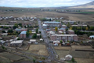
Kober kayaran (Armenian : Քոբեր կայարան), is a village in the Lori Province of Armenia. It belongs to the municipality of Tumanyan. [1] At the top of the tiny hillside village is Kobayr Monastery

Armenian language Indo-European language

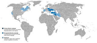
The Armenian language is an Indo-European language spoken primarily by Armenians. It is the official language of Armenia. Historically being spoken throughout the Armenian Highlands, today, Armenian is widely spoken throughout the Armenian diaspora. Armenian is written in its own writing system, the Armenian alphabet, introduced in 405 AD by Mesrop Mashtots.

Lori Province Province in Armenia

Lori, is a province (marz) of Armenia. It is located in the north of the country, bordering Georgia. Vanadzor is the capital and largest city of the province. Other important towns include Stepanavan, Alaverdi, and Spitak. It is home to the UNESCO World Heritage Sites of Haghpat and Sanahin monasteries and the well-preserved Akhtala monastery, where Armenians, Georgians, and Greeks make an annual pilgrimage on September 20–21.

Tumanyan, Armenia Place in Lori, Armenia

Tumanyan, is a town and urban municipal community in the Lori Province of Armenia, located 149 km north of the capital Yerevan, and 38 km north of the provincial centre Vanadzor. As of the 2011 census, the population of Tumanyan is 1,710, declining from 2,864 reported in 1964. Currently, the town has an approximate population of 1,000 as per the 2016 official estimate. The nearby villages of Kober kayaran, Shamut, Lorut, Ahnidzor, Atan, Marts and Karinj are also part of the Tumanyan community.

Related Research Articles

Agarak, Lori Place in Lori, Armenia

Agarak is a village in the Lori Province of Armenia. It lies at the end of the H-33 highway. The area is dominated by agriculture.

Hagvi Place in Lori, Armenia

Hagvi is a village in the Lori Province of Armenia.

Akner, Lori Place in Lori, Armenia

Akner, is a village belongs to the municipal community of Alaverdi, in the Lori Province of Armenia.

Ardvi Place in Lori Province, Armenia

Ardvi is a village in the Lori Province of Armenia.

Chochkan Place in Lori Province, Armenia

Chochkan is a village in the Lori Province of Armenia.

Dashtadem, Lori Place in Lori, Armenia

Dashtadem, is a village in the Lori Province of Armenia.

Kachachkut Place in Lori Province, Armenia

Kachachkut is a village in the Lori Province of Armenia. The population is mainly self-worked in animal husbandry, horticulture and cultivation.

Karinj Place in Lori, Armenia

Karinj is a village in the Lori Province of Armenia. It belongs to the municipality of Tumanyan.

Katnaghbyur, Lori Place in Lori, Armenia

Katnaghbyur is a village in the Lori Province of Armenia.

Mets Ayrum Place in Lori, Armenia

Mets Ayrum is a village in the Lori Province of Armenia.

Mikhayelovka Place in Lori Province, Armenia

Mikhayelovka is a village in the Lori Province of Armenia.

Neghots Place in Lori Province, Armenia

Neghots, is a village in the Lori Province of Armenia.

Noramut Place in Lori Province, Armenia

Noramut, is a village in the Lori Province of Armenia.

Novoseltsovo Place in Lori Province, Armenia

Novoseltsovo is a village in the Lori Province of Armenia.

Petrovka, Armenia Place in Lori, Armenia

Petrovka is a village in the Lori Province of Armenia.

Tsaghkahovit Place in Aragatsotn, Armenia

Tsaghkahovit, known as Haji Khalil until 1946, is a village in the Aragatsotn Province of Armenia. There are many Late Bronze Age remains which are in the process of being excavated.

Nor Artagers Place in Armavir, Armenia

Nor Artagers, is a village in the Armavir Province of Armenia. The village is inhabited by Armenians, Yazidis and Assyrians.

Karkop Place in Lori Province, Armenia

Karkop is a village in the Lori Province of Armenia.

Getavan, Armenia Place in Lori, Armenia

Getavan is a village in the Lori Province of Armenia.

Akhtala aroghjaranin kits Place in Lori, Armenia

Akhtala aroghjaranin kits, is a village in the Lori Province of Armenia. It belongs to the municipality of Akhtala.

References