
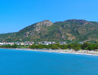
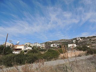
Kokkino Chorio ("Red Village" in English) is a village situated in the Chania regional unit of Crete, Greece.
Contents
Kokkino Chorio is located near Plaka, Almiryda, Gavlahori, Kalyves and Kambia.
Kokkino Chorio ("Red Village" in English) is a village situated in the Chania regional unit of Crete, Greece.
Kokkino Chorio is located near Plaka, Almiryda, Gavlahori, Kalyves and Kambia.

The village also plays host to a tunnel complex which was used in World War II by the Nazis as an artillery spotting position. The area has been bought by a local property developer who has subsequently built a large number of houses on the site, obliterating in the process an old gun emplacement. In 2006 a memorial to those killed during world war two was constructed at the entrance to the tunnels.
It was the filming location of the 1964 film Zorba the Greek starring Anthony Quinn, Alan Bates, Irene Papas and many locals. Access is possible, but it is unlit.
Kokkino Chorio has three churches: St. George's which is located at the entrance of the cave and used on St. George's Day (April 23); St Katherines in the village which is used on November 25. The main church, used weekly and at other times during Lent/Easter and Advent/Christmas is St. Haralambos and is located in the village square.
Recently[ when? ] a Mini Market has opened in Kokkino Chorio (run by Giorgos) selling a range of goods, from food to household appliances.
There is also a Glass blowing factory in the village with an embryo taverna attached.
Above Kokkino Horio one can see the strangely shaped hill Drapanokefala or Calapodha (so named during the Venetian occupation). The coastline northwest of the village is an extremely interesting place for a stroll due to the ground formation and the caves, such as the cave of Petsi (or Karavotopos). Another cave called Katalimata, located at the centre of the village, is also an interesting site.
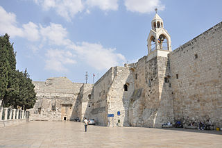
The Church of the Nativity, or Basilica of the Nativity, is a basilica located in Bethlehem in the State of Palestine, in the West Bank. The grotto holds a prominent religious significance to Christians of various denominations as the birthplace of Jesus. The grotto is the oldest site continuously used as a place of worship in Christianity, and the basilica is the oldest major church in the Holy Land.

Antiparos (Greek: Αντίπαρος; Ancient Greek: Ὠλίαρος, romanized: Oliaros; Latin: Oliarus; is a small island in the southern Aegean, at the heart of the Cyclades, which is less than one nautical mile from Paros, the port to which it is connected with a local ferry. Saliagos island is the most ancient settlement in the Cyclades, and Despotiko, an uninhabited island in the southwest of Antiparos, is a place of great archaeological importance.
Kalo Chorio is a village in the municipality of Agios Nikolaos, Lasithi, Crete, Greece. Kalo Chorio village has a population of around 900, nestled attractively in the midst of a verdant hilly landscape, where olive groves, abundant and colorful mediterranean shrubs and plants reach all the way down to the sea. Over the past years, naturally with tourism, part of the village has grown nearer to the beach. Istro has many archaeological points of interest. The new village of Istro sits on the site of the ancient town of Istron, remains of which are still being uncovered to date. Because of this, the land closest to the sea has a conservation order and no new building may take place, which leaves the beaches uncrowded and unspoiled. The delightful beaches of Istro Bay are regularly awarded a Blue flag for cleanliness. Kalo Chorio offers a village atmosphere away from the sprawling concrete covered resorts usually found in Crete, allowing visitors to enjoy Crete as it once was.
Goúves is a village and former municipality in the Heraklion regional unit, Crete, Greece. Since 2011, local government reform it is a part of the municipality Hersonissos, of which it is a municipal unit. The municipal unit has an area of 94.963 km2 (36.665 sq mi). It lies around 20 km (12 mi) east of Heraklion.

Amioun is the capital of the predominantly Greek Orthodox Koura District in North Lebanon.

Psychro Cave is an ancient Minoan sacred cave in Lasithi plateau in the Lasithi district of eastern Crete. Psychro is associated with the Diktaean Cave, one of the putative sites of the birth of Zeus. Other legends place Zeus' birthplace as Idaean Cave on Mount Ida. According to Hesiod, Theogony, Rhea gave birth to Zeus in Lyctus and hid him in a cave of Mount Aegaeon. Since the late nineteenth century the cave above the modern village of Psychro has been identified with Diktaean Cave, although there are other candidates, especially a cave above Palaikastro on Mount Petsofas.

Othonoi is a small inhabited Greek island in the Ionian Sea, located northwest of Corfu, and is the westernmost point of Greece. Othonoi is the largest and most populated of the Diapontian Islands. Since the 2019 local government reform it is part of the municipality of Central Corfu and Diapontian Islands.

Xiro Chorio is a hamlet of approximately 170 residents, which is part of the city of Rethymno, capital of Rethymno regional unit in the island of Crete, Greece.

The Derinkuyu underground city is an ancient multi-level underground city of the Median Empire in the town of Derinkuyu in Nevşehir Province, Turkey, extending to a depth of approximately 85 metres (280 ft). It is large enough to have sheltered as many as 20,000 people together with their livestock and food stores. It is the largest excavated underground city in Turkey and is one of several underground complexes found throughout Cappadocia.

The Church of Saint Peter near Antakya (Antioch), Turkey, is composed of a cave carved into the mountainside on Mount Starius with a depth of 13 m (42 ft.), a width of 9.5 m (31 ft.) and a height of 7 m (23 ft).

Dryopida is a village in Kythnos island, Greece. It most likely got its name from the first residents of the island, the Dryopes. It is declared as a traditional settlement because of its architecture. The village has an estimated 325 inhabitants, according to the 2011 census poll.
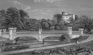
Mysterious tunnels or "secret passages" are a common element of the local folklore tradition in Europe. Such tunnels are said to physically link prominent places such as country houses, castles, churches, ancient monuments and other, often medieval, buildings.
Tremithousa is a village in the Paphos District of Cyprus, located 7 km north of Paphos. Tremithousa is located 294 m above sea level. Tremithousa is located near Mesa Chorio and Mesogi Village. Tremithousa receives an average annual rainfall of about 520 millimeters; vines of winemaking varieties, vegetables, cereals, forage plants, citrus, almond, and walnut trees, and legumes are cultivated in the region. The village has a reputation for the aromatic and tasty honey that it produces. Tremithousa connects in the north to the monastery of Agios Neofytos, in the northeast with the village of Tala, and in the east with the main road of Tsada – Polis.

Greek National Road 90, also known as VOAK is the longest National Highway on the island of Crete, Greece. It runs along the north coast of the island Crete. It connects Kissamos in the west with Siteia in the east, via Chania, Rethymno, Heraklion and Agios Nikolaos.

The Tomb of the Prophets Haggai, Zechariah and Malachi is an ancient burial site located on the upper western slope of the Mount of Olives, Jerusalem. According to a medieval Jewish tradition also adopted by Christians, the catacomb is believed to be the burial place of Haggai, Zechariah and Malachi, the last three Hebrew Bible prophets who are believed to have lived during the 6th–5th centuries BC. Archaeologists have dated the three earliest burial chambers to the 1st century BC, thus contradicting the tradition.
Akraifnio, before 1933 known as Karditsa (Καρδίτσα), is a village in Boeotia, Greece.
Neo Chorio is a village located 25km southeast of Chania in the center of the Apokoronas province. It was named Neo ("new") Chorio because it was a new village, but it was built on the ruins of an old village which was destroyed during the raids in Crete. It is built on a stone hill on a plain that is crossed by the river Mantamas. Smaller rivers include: the Anavreti, the Koliakoudes, etc. According to tradition, the small town was originally settled in the Late Minoan era, on a site located in the northernmost part of the village where it still stands today. According to the census of 1881, the village had only 451 inhabitants. At the village square, there is a plane tree which is many centuries old. Under this tree, there is a famous well. The plane tree and the well have been there since the Venetian domination. In the past, water was supplied by the rivers Koliakoude and Mantama. Later, when the village was destroyed, the inhabitants moved south and people collected water from the Koliakoude river. Even today, there are still many wells and cisterns within the village, the most important of which is the well of Anavreti. Agios Thomas’s church is located in the village’s square and is a royal rhythm church. In the Turkish domination this church was used as a cemetery and a school. The Agios Gerasimos is a graphic little church which was built on a rock at the edge of the village going towards to Bryses. The Agios Therapontas church is Byzantine rhythm and was built in 1971. Today, the cemetery is located on a hill 100 meters high, located near the church of Koimisi tis Theotokou. During the Turkish domination, priests and nuns took on the role of teachers and secretly taught the Greek language to the children of the village. The only school in the village was built in 1900. The fort of Koule was built by the Turks to control the passage from Apokoronas to Keramia.

Oktonia is a hillside village found in the east-central area of Evia Island, belonging to the Municipality of Kimi-Aliveri, Greece. Located near the lower side of the Gulf of Kimi, the village is composed of four communities, Alonia, Panochori, Katochori and Panagia, covering a large area. It is 145 km from Athens, a distance covered in about 2.5 hours by car, making it a destination for both winter and summer holidays. According to the census of 2011, Oktonia has 455 permanent inhabitants.