Kosovo, officially the Republic of Kosovo, is a country in Southeast Europe with partial diplomatic recognition.
Agualeguas is both a city and a municipality located in the northeastern part of the state of Nuevo León, Mexico,. The name "Agualeguas" honors the first inhabitants of the region, the Gualegua tribe. It was recognized as a village on January 7, 1821, by the colonial government when Bro. Diego Velázquez declared it the village of "St. Nicholas of Gualeguas."
Sahalahti is a former municipality of Finland. It was located in the province of Western Finland and was part of the Pirkanmaa region. The municipality had a population of 2,229 (2003) and covered an area of 171.96 km² of which 35.09 km² was water. The population density was 16.3 inhabitants per km². Sahalahti joined to Kangasala on January 1, 2005. Its original administrative center was the village by the same name.
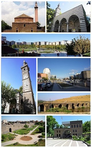
Diyarbakır Province is a province and metropolitan municipality in southeastern Turkey. Its area is 15,101 km2, and its population is 1,804,880 (2022). The provincial capital is the city of Diyarbakır. The Kurdish majority province is part of Turkish Kurdistan.
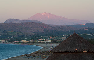
Georgioupoli is a resort village and former municipality in the Chania regional unit, Crete, Greece. Since the 2011 local government reform it is part of the municipality Apokoronas, of which it is a municipal unit. The municipal unit has an area of 53.498 km2 (20.656 sq mi). It is located 39 kilometres east of Chania, about 23 km (14 mi) west of Rethymno and about 100 km (62 mi) west of Heraklio. It was named after Prince George of Greece, high commissioner of the island in the last years of Ottoman occupation.

Chania, also spelled Hania, is one of the four regional units of Crete; it covers the westernmost quarter of the island. Its capital is the city of Chania. Chania borders only one other regional unit: that of Rethymno to the east. The western part of Crete is bounded to the north by the Cretan Sea(part of the Aegean Sea) and to the west and south by the Mediterranean Sea and Libyan Sea. The regional unit also includes the southernmost island of Europe, Gavdos.
Mladenovo is a village located in the Bačka Palanka municipality, in the South Bačka District of Serbia. It is situated in the Autonomous Province of Vojvodina. The village has a Serb ethnic majority and its population numbering 3,358 people.

Pali district is a district in Rajasthan, India. The city of Pali is its administrative headquarters. Pali is also known as the Industrial/Textile City and has been a hub for merchant activities for centuries. It has a rich heritage and culture, including beautiful Jain temples and other elaborate monuments.

Lenartovce is a village and municipality in the Rimavská Sobota District of the Banská Bystrica Region of southern Slovakia. It has 546 inhabitants.

Hrašovík is a village and municipality in Košice-okolie District in the Košice Region of eastern Slovakia.

Dolné Obdokovce is a village and municipality in the Nitra District in western central Slovakia, in the Nitra Region.
Koxari is a village near Iraklion (Heraklion) in Crete. It is in the Municipality of Gouves. The village is at an altitude of 180 meters and is 23.3 km from Heraklion.

Valdepiélagos is a municipality of the Community of Madrid, Spain. It received the title of villa (town) on 3 May 1801.
Jeita is a town and municipality located in the Keserwan District of the Keserwan-Jbeil Governorate of Lebanon. The town is about 20 kilometres (12 mi) north of Beirut. It has an average elevation of 380 meters above sea level and a total land area of 290 hectares. Jeita's inhabitants are Maronites.

Kočani Valley is located along the river Bregalnica in the eastern part of North Macedonia, at the latitude of 41° and 55' and longitude 22° and 25'. It covers an area of 1020 km² and extends from both sides of Bregalnica, stretching from west-southwest to east-northeast, with a length of 26 km. The bottom of the valley, i.e. its flat portion, covers an area of 115 km². The lowest point is in the western part, where the Zletovska River flows into the Bregalnica, at an altitude of 290 meters. Going east, the elevation gradually rises up to 330 meters. The difference between the lowest to the highest elevation of the valley is 40 meters.
Gudžiai is a village in Varėna district municipality, in Alytus County, in southeastern Lithuania. According to the 2001 census, the village has a population of 400 people.

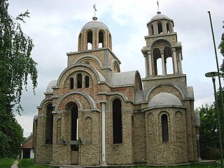
Delimeđe is a village in the municipality of Tutin, Serbia. According to the 2002 census, the village has a population of 445 people. The two minarets of the mosque constructed in 2013, with the height of 77.2 meters, are the tallest in Serbia and in Europe outside of Turkey.
Lopatanj is a village located in Osečina Municipality, Kolubara District, Serbia.
The strategic position of the region of Mitrovica in the middle of two great rivers Ibar and Sitnica and its mineral wealth in Albanik, made this location populated since prehistoric period. This region was populated by Illyrians, respectively members of the Dardan tribe. The first data for the archaeological sites in the region of Mitrovica, begin with the researches of Sir Artur John Evans, who was the first to pinpoint the Roman town of the Municipium Dardanourm. In the archaeological sites of the region of Mitrovica were found traces and objects from different periods such as; Neolithic, Roman, late antiquity and medieval period. Objects and figurines include: fortress vestiges, necropolis, Terpsichore figure, statues, sarcophagus, altar, jewelry, etc.

Tsalka Canyon is part of Khrami gorge near Dashbashi village, 3 km from the small town of Tsalka, in Tsalka Municipality, in Kvemo Kartli region of southeastern Georgia, 1,110-1,448 meters above sea level. The distance from Tsalka Canyon to the popular Algeti National Park is 42 km.
