
Haskovo is a city in the region of Northern Thrace in southern Bulgaria and the administrative centre of the Haskovo Province, not far from the borders with Greece and Turkey. According to Operative Program Regional Development of Bulgaria, the urban area of Haskovo is the seventh largest in Bulgaria and has a population of 184,731 inhabitants. Haskovo has a population of 64,564 as of 2022, making it Bulgaria's 12th largest city.

The provinces of Bulgaria are the first-level administrative subdivisions of the country.

Blagoevgrad Province, also known as Pirin Macedonia or Bulgarian Macedonia, is a province (oblast) of southwestern Bulgaria. It borders four other Bulgarian provinces to the north and east, the Greek region of Macedonia to the south, and North Macedonia to the west. The province has 14 municipalities with 12 towns. Its principal city is Blagoevgrad, while other significant towns include Bansko, Gotse Delchev, Melnik, Petrich, Razlog, Sandanski, and Simitli.

Kardzhali Province is a province of southern Bulgaria, neighbouring Greece with the Greek regional units of Xanthi, Rhodope, and Evros to the south and east. It is 3209.1 km2 in area. Its main city is Kardzhali. It is Bulgaria's southernmost province.

Haskovo Province is a province in southern Bulgaria, neighbouring Greece and Turkey to the southeast, comprising parts of the Thracian valley along the river Maritsa. It is named after its administrative and industrial centre: the city of Haskovo. The province has a territory of 5,533.3 km2 (2,136.4 sq mi) that is divided into 11 municipalities with a total population, as of December 2009, of 256,408 inhabitants.

Gabrovo Province is a small province lying at the geographical centre of Bulgaria. It is named after its main town - Gabrovo. In 2009 the total population of the area was 130,001.
Montana Province is a province in northwestern Bulgaria, bordering Serbia in the southwest and Romania in the north. It spreads its area between the Danube river and the Balkan Mountains. As of February 2011, the province had a population of 148,098, on territory of 3,635.5 km2 (1,403.7 sq mi). It was named after its administrative centre the city of Montana.

Radomir is a town in the Radomir Municipality in the Pernik Province of Bulgaria.

Klaus Meine is a German singer, best known as the longtime frontman and primary lyricist of the hard rock band Scorpions. Meine and guitarist Rudolf Schenker are the only two members of the group to appear on every Scorpions album, though he did not join the band until 1969, four years after its founding. Meine placed at number 22 on Hit Parader's 'Top Heavy Metal Vocalists of All Time' list in 2006.

Liel Kolet is an Israeli singer-songwriter and a peace advocate.

six4one was a six-piece supergroup formed in November 2005 for the sole purpose of representing Switzerland at the Eurovision Song Contest 2006. The group was made up of six people who were chosen at a casting session that took place November 25–27, 2005. The group were not created as a long-term manufactured band, but instead as "six strong voices" who could collaborate at the contest, and then go their separate ways after the final.

Sredets is a town in Burgas Province in southeastern Bulgaria. It is located near Lake Mandrensko and the northern slopes of Strandzha. Sredets is the administrative centre of Sredets Municipality.
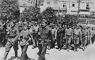
The 1944 Bulgarian coup d'état, also known as the 9 September coup d'état, was a coup that overthrew the government of Kingdom of Bulgaria carried out on the eve of 9 September 1944. During the People's Republic of Bulgaria it was called using the propaganda term People's Uprising of 9 September – on the grounds of the broad unrest and Socialist Revolution – as it was a turning point politically and the beginning of radical reforms towards Soviet-style socialism.
Tervel is a town in northeastern Bulgaria, part of Dobrich Province. It is the administrative centre of Tervel Municipality, which lies in the westernmost part of the province. As of December 2009, the town had a population of 6,667.

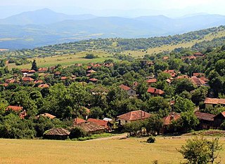
Haskovski Mineralni Bani, officially known as Mineralni Bani is a spa village in central southern Bulgaria, part of Haskovo Province. It is the administrative centre of Mineralni Bani Municipality, which lies in the westernmost part of Haskovo Province. The village's name means "Haskovo Mineral Baths".

Strezimirovci is a divided village in easternmost Serbia and westernmost Bulgaria. The Bulgarian half of the village is part of Tran Municipality, Pernik Province, whereas the Serbian part belongs to Surdulica municipality, Pčinja District. The village has a border checkpoint, and its residents on either side of the border are mostly Bulgarian; however, its division has caused its population to decrease more than tenfold. It lies in the geographic region of Znepolje (Znepolјe), at 42°48′N22°26′E, in a valley along the Jerma River, 830 metres above mean sea level.
Colette Deréal was a French actress and singer.
Kolet is a village in Mehravan Rural District, in the Central District of Neka County, Mazandaran Province, Iran. At the 2006 census, its population was 961, in 229 families.
