
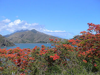
The Koniambo Massif is a mountain range near the town of Voh on the west coast of the North Province of New Caledonia, a French territory in the south-west Pacific Ocean. It is the site of a large nickel mine, [1] of the laterite variety. [2]
The Koniambo Massif is a mountain range near the town of Voh on the west coast of the North Province of New Caledonia, a French territory in the south-west Pacific Ocean. It is the site of a large nickel mine, [1] of the laterite variety. [2]
A 12,000 ha (30,000-acre) tract of largely forested land encompassing the Koniambo Massif has been identified by BirdLife International as the Koniambo Massif Important Bird Area (IBA) because it is a breeding site for an estimated 200–400 pairs of burrow-nesting Tahiti Petrels. Potential threats to the birds come from a suite of invasive species, including rodents, feral pigs and cats, as well as from mining operations and disorientation from light pollution. [1]
An associated area of 103,005 hectares (254,530 acres) of sea, based on a seaward extension of 25 kilometres (16 mi) from the Koniambo Massif has been identified as a separate IBA, the Voh Marine Important Bird Area, which encompasses the foraging range of the breeding colony of the petrels. Potential threats in this area include fishing and marine pollution. [3]

The Scullin Monolith is a crescent-shaped rock fronting the sea 6 km (3.7 mi) west of the similar Murray Monolith, and 8 km (5.0 mi) from Torlyn Mountain, in Mac. Robertson Land, Antarctica. It is a steep massif of metasedimentary gneiss and granitic origin, with the adjacent coastline consisting of 40 m high ice cliffs. The monolith rises steeply to extend from 435 m high Mikkelsen Peak westward in a crescent that forms Douglas Bay.
Cormorant Island is a 10 ha island lying in Bismarck Strait 1 km south of Anvers Island, 4 km (2.5 mi) east-south-east of Bonaparte Point, in the Palmer Archipelago of Antarctica. It lies some 5 km to the south-east of the United States' Palmer Station in Arthur Harbour on Anvers Island. It was shown on an Argentine government chart of 1954, but not named. It was named by the United Kingdom Antarctic Place-names Committee (UK-APC) in 1958 because of the large number of cormorants (shags) seen there.

Litchfield Island is a rocky island 0.9 kilometres (0.5 nmi) long and rising to 50 m (164 ft), lying in Arthur Harbour, 0.9 kilometres (0.5 nmi) south of Norsel Point, off the south-west coast of Anvers Island in the Palmer Archipelago of Antarctica.
The Robertson Islands or Robertsons Islands are a group of islands extending 6 km southward of the south-eastern extremity of Coronation Island in the South Orkney Islands of Antarctica. They were discovered and roughly charted by Captains George Powell and Nathaniel Palmer in December 1821 and named by James Weddell in 1823.

The Seal Islands are a group of small islands and rocky islets lying about 7 km north and north-west of Elephant Island, in the South Shetland Islands of Antarctica. They extend east–west for about 5 km, and are separated from Elephant Island by Sealers Passage. The group takes its name from the largest island, which Captain William Smith named Seal Island in 1820 because of the number of seals killed there.
Beall Island is a rocky island with small coves indenting the eastern and western sides, lying 600 m (660 yd) south-west of the Bailey Peninsula, in the Windmill Islands on the Budd Coast of Antarctica. There are several small lakes on the island. It was first mapped from aerial photos taken by the USN's Operation Highjump and Operation Windmill in 1947 and 1948. It was named by the US-ACAN for James M. Beall, U.S. Weather Bureau observer with Operation Windmill who assisted staff aerology officers with forecasting duties. The Beall Reefs are submarine ridges with depths of less than 1.8 metres, located 1 kilometre (0.6 mi) west of the island; they were discovered at the establishment of Wilkes Station in 1961 and named by ANCA after the island. Connors Point is the north-western point of the island; it was named by the US-ACAN for Aerographer's Mate William J. Connors, USN, a member of the Wilkes Station party of 1958.

Shirley Island is a rocky island lying 200 m (220 yd) north-west of the western end of the Bailey Peninsula, in the Windmill Islands of the Budd Coast, Wilkes Land, Antarctica. It is mostly ice-free with undulating, rocky terrain. It was first mapped from aerial photos taken by the USN's Operation Highjump in February 1947. It was named by the US-ACAN for Q. Shirley, chief photographer's mate on Operation Highjump photographic flights in coastal areas between 14° and 164° E longitude. Kirkby Shoal is a small shoal area with depths of less than 18 meters (59 ft) extending about 140 meters (459 ft) westwards and south-south-west, about 3.4 km (2.1 mi) from the summit of Shirley Island. Launch Channel is the narrow body of water between Bailey Peninsula and the island; with the relatively shallow soundings in the channel restricting its use to smaller craft and suggesting the name.

Barau's petrel is a medium-sized gadfly petrel from the family Procellariidae. Its main breeding site is the island of Réunion in the Indian Ocean.
Mont Panié is a mountain on the island of Grande Terre in New Caledonia, a special collectivity of France located in the south-west Pacific Ocean. At 1,628 metres (5,341 ft), it is the island's highest point. Mont Panié is situated in the Chaîne Centrale mountain range. The second highest peak on the island, Mount Humboldt, is nearly as tall as Mont Panié, with an elevation of 1,618 metres (5,308 ft).

The white-bellied storm petrel is a species of seabird in the family Oceanitidae. It is found in Angola, Argentina, Australia, Brazil, Chile, Ecuador, French Polynesia, French Southern Territories, Maldives, Namibia, New Zealand, Perú, Saint Helena, and South Africa. Its natural habitat is open seas.

The Tahiti petrel is a medium-sized, dark brown and white seabird found across the Pacific Ocean. The species comprises two subspecies: P. r. rostrata which breeds in the west-central Pacific Ocean, and P. r. trouessarti which breeds in the tropical and subtropical Pacific Ocean. The Tahiti petrel belongs to the Procellariidae family and is the most studied member of the Pseudobulweria genus which comprises three critically endangered species. Similarly, the Tahiti petrel is considered near threatened by the 2018 IUCN Red List of Threatened Species. Threats include introduced rats, feral cats, pigs, dogs, nickel mining, and light pollution.
Murray Monolith is a detached part of Torlyn Mountain in Mac.Robertson Land, Antarctica. It is a steep massif of metasedimentary gneiss and granitic origin, with the adjacent coastline consisting of 40 m high ice cliffs. The monolith is dome-shaped with steep sides, rising to a seaward summit of 339 m and an inland summit of 363 m at Torlyn Mountain.

The Joubin Islands are a group of small islands lying 6 kilometres (3 nmi) south-west of Cape Monaco, Anvers Island, at the south-western end of the Palmer Archipelago of Antarctica. The islands were discovered by the French Antarctic Expedition, 1903–05, under Jean-Baptiste Charcot, and named by him for Louis Joubin, the French naturalist. They have been designated a Restricted Zone under ASMA 7 — Southwest Anvers Island and Palmer Basin — which includes the marine area extending 50 metres (55 yd) from the shorelines.
Lions Rump is a conspicuous headland 2 km (1.2 mi) north-northeast of Low Head, forming the west side of the entrance to King George Bay, on King George Island, in the South Shetland Islands of Antarctica. It was charted and given its descriptive name in 1937 by Discovery Investigations personnel on the Discovery II. Chopin Ridge runs between Lions Rump and Low Head. The rock feature known as "Martello Tower" lies 4 km (2.5 mi) to the north-northwest.

Baie Larose, or Larose Bay in English, is a bay of Grande Terre, the main island of the subantarctic Kerguelen archipelago, a French territory in the southern Indian Ocean. It is important as a breeding site for seabirds, especially penguins.

The Elephant Cays are a group of small islands lying towards the southern end of Falkland Sound, just to the north-west of Speedwell Island, in the Falkland Islands of the South Atlantic Ocean. The group, with a collective area of 248 ha includes Golden Knob, Sandy Cay, West, Southwest and Stinker Islands. It has been identified by BirdLife International as an Important Bird Area (IBA).

The Cierva Point and offshore islands Important Bird Area is a 6540 ha tract of land and sea on the Danco Coast of the Antarctic Peninsula.

Point Wordie is a headland on the western coast of Elephant Island, in the South Shetland Islands of Antarctica. The site is named after James Wordie, a Scottish geologist who participated in Ernest Shackleton’s Imperial Trans-Antarctic Expedition, 1914–1917.

The Southern Powell Island and adjacent islets Specially Protected Area is a 2688 ha site encompassing part of southern Powell Island in the South Orkney Islands of Antarctica. It includes neighbouring Christoffersen, Fredriksen, Michelsen and Grey Islands, along with some other (unnamed) offshore islets. It was designated an Antarctic Specially Protected Area because of its biological values as it supports many plants and animals that exemplify the natural ecology of the South Orkney Islands. It is also a breeding site for Antarctic fur seals.

Baily Head is a prominent headland, 160 m high, forming the easternmost extremity of Deception Island, in the South Shetland Islands of Antarctica.
20°59′53″S164°48′57″E / 20.99806°S 164.81583°E
| | This New Caledonian location article is a stub. You can help Wikipedia by expanding it. |