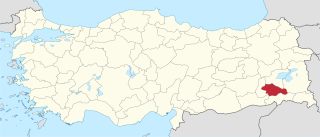
Siirt Province, is a province of Turkey, located in the southeast. The province borders Bitlis to the north, Batman to the west, Mardin to the southwest, Şırnak to the south, and Van to the east. It has an area of 5,406 km² and a total population of 300,695. The provincial capital is the city of Siirt. The majority of the province's population is Kurdish.

Oriovac is a village and municipality in Brod-Posavina County, Croatia. Its coordinates are 45°9′58″N17°45′36″E. It has 6,559 inhabitants in 2001.

Lutomia Dolna is a village in the administrative district of Gmina Świdnica, within Świdnica County, Lower Silesian Voivodeship, in south-western Poland. Prior to 1945 it was in Germany.

Ticușu is a commune in Brașov County, Romania. It is composed of two villages, Cobor and Ticușu Vechi.
Pulczynów is a village in the administrative district of Gmina Frampol, within Biłgoraj County, Lublin Voivodeship, in eastern Poland. It lies approximately 8 kilometres (5 mi) south-east of Frampol, 12 km (7 mi) north of Biłgoraj, and 68 km (42 mi) south of the regional capital Lublin.
Dalny Las is a village in the administrative district of Gmina Płaska, within Augustów County, Podlaskie Voivodeship, in north-eastern Poland, close to the border with Belarus.
Lichawa is a village in the administrative district of Gmina Szadek, within Zduńska Wola County, Łódź Voivodeship, in central Poland. It lies approximately 7 kilometres (4 mi) north of Szadek, 18 km (11 mi) north of Zduńska Wola, and 33 km (21 mi) west of the regional capital Łódź.
Laski Dworskie is a village in the administrative district of Gmina Gołcza, within Miechów County, Lesser Poland Voivodeship, in southern Poland. It lies approximately 8 kilometres (5 mi) south of Gołcza, 13 km (8 mi) south-west of Miechów, and 23 km (14 mi) north of the regional capital Kraków.
Olchowa is a village in the administrative district of Gmina Iwierzyce, within Ropczyce-Sędziszów County, Subcarpathian Voivodeship, in south-eastern Poland.
Boczkowice is a village in the administrative district of Gmina Włoszczowa, within Włoszczowa County, Świętokrzyskie Voivodeship, in south-central Poland. It lies approximately 12 kilometres (7 mi) south-east of Włoszczowa and 43 km (27 mi) west of the regional capital Kielce.
Brzeście is a village in the administrative district of Gmina Kluczewsko, within Włoszczowa County, Świętokrzyskie Voivodeship, in south-central Poland. It lies approximately 4 kilometres (2 mi) south of Kluczewsko, 6 km (4 mi) north-west of Włoszczowa, and 49 km (30 mi) west of the regional capital Kielce.
Maleniec is a village in the administrative district of Gmina Secemin, within Włoszczowa County, Świętokrzyskie Voivodeship, in south-central Poland.
Daniłowo-Parcele is a village in the administrative district of Gmina Małkinia Górna, within Ostrów Mazowiecka County, Masovian Voivodeship, in east-central Poland.
Bobrowiec is a village in the administrative district of Gmina Smętowo Graniczne, within Starogard County, Pomeranian Voivodeship, in northern Poland. It lies approximately 3 kilometres (2 mi) north-west of Smętowo Graniczne, 25 km (16 mi) south of Starogard Gdański, and 68 km (42 mi) south of the regional capital Gdańsk.
Pachoły is a village in the administrative district of Gmina Dzierzgoń, within Sztum County, Pomeranian Voivodeship, in northern Poland.
Potęgowo is a village in the administrative district of Gmina Linia, within Wejherowo County, Pomeranian Voivodeship, in northern Poland. It lies approximately 4 kilometres (2 mi) south of Linia, 29 km (18 mi) south-west of Wejherowo, and 47 km (29 mi) west of the regional capital Gdańsk.

Chimboy District is a district of Karakalpakstan in Uzbekistan. The capital lies at Chimboy.
Kondar is a town and commune in the Sousse Governorate, Tunisia.
Koigi is a village in Rapla Parish, Rapla County in northwestern Estonia.
Tarjanli is a village in Qaravolan Rural District, Loveh District, Galikash County, Golestan Province, Iran. At the 2006 census, its population was 1,162, in 313 families.


